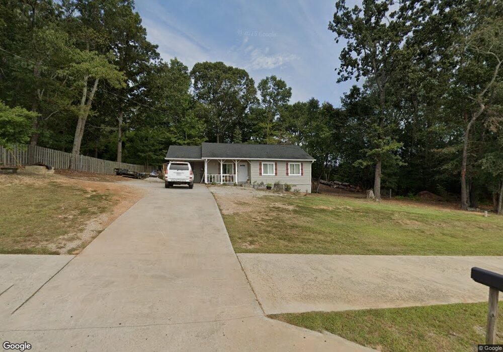
2555 Friendship Rd Buford, GA 30519
Estimated Value: $291,374 - $385,000
3
Beds
2
Baths
1,005
Sq Ft
$319/Sq Ft
Est. Value
About This Home
This home is located at 2555 Friendship Rd, Buford, GA 30519 and is currently estimated at $320,594, approximately $318 per square foot. 2555 Friendship Rd is a home located in Hall County with nearby schools including Friendship Elementary School, Cherokee Bluff Middle School, and Cherokee Bluff High School.
Ownership History
Date
Name
Owned For
Owner Type
Purchase Details
Closed on
May 27, 2022
Sold by
Jay John B
Bought by
Vasquez Santiago Mariano and Alaniz Hilaria Arellano
Current Estimated Value
Home Financials for this Owner
Home Financials are based on the most recent Mortgage that was taken out on this home.
Original Mortgage
$216,000
Outstanding Balance
$205,218
Interest Rate
5.1%
Mortgage Type
New Conventional
Estimated Equity
$115,376
Purchase Details
Closed on
Oct 5, 2000
Sold by
Robinson Paul D and Robinson Tina L
Bought by
Jay John B and Jay Julia
Home Financials for this Owner
Home Financials are based on the most recent Mortgage that was taken out on this home.
Original Mortgage
$59,200
Interest Rate
7.96%
Mortgage Type
New Conventional
Create a Home Valuation Report for This Property
The Home Valuation Report is an in-depth analysis detailing your home's value as well as a comparison with similar homes in the area
Home Values in the Area
Average Home Value in this Area
Purchase History
| Date | Buyer | Sale Price | Title Company |
|---|---|---|---|
| Vasquez Santiago Mariano | $275,000 | -- | |
| Jay John B | $74,000 | -- |
Source: Public Records
Mortgage History
| Date | Status | Borrower | Loan Amount |
|---|---|---|---|
| Open | Vasquez Santiago Mariano | $216,000 | |
| Previous Owner | Jay John B | $59,200 |
Source: Public Records
Tax History Compared to Growth
Tax History
| Year | Tax Paid | Tax Assessment Tax Assessment Total Assessment is a certain percentage of the fair market value that is determined by local assessors to be the total taxable value of land and additions on the property. | Land | Improvement |
|---|---|---|---|---|
| 2024 | $2,554 | $100,480 | $12,960 | $87,520 |
| 2023 | $2,386 | $93,680 | $12,960 | $80,720 |
| 2022 | $1,083 | $39,200 | $7,680 | $31,520 |
| 2021 | $1,057 | $37,480 | $7,680 | $29,800 |
| 2020 | $1,044 | $35,880 | $7,680 | $28,200 |
| 2019 | $907 | $30,560 | $7,680 | $22,880 |
| 2018 | $836 | $27,040 | $7,680 | $19,360 |
| 2017 | $792 | $25,760 | $7,680 | $18,080 |
| 2016 | $755 | $25,021 | $7,040 | $17,981 |
| 2015 | $760 | $25,021 | $7,040 | $17,981 |
| 2014 | $760 | $25,021 | $7,040 | $17,981 |
Source: Public Records
Map
Nearby Homes
- 2638 Democracy Dr Unit 1
- 3134 Perimeter Cir
- 2342 Sparta Way
- 2941 Climbing Rose St
- 2228 Mayors Way
- 3088 Lantana Way
- 3138 Lantana Way
- 4761 Moon Chase Dr
- 4732 Moon Chase Dr
- 4728 Moon Hollow Ct
- 7272 Coral Lake Dr
- 7235 Coral Lake Dr
- 7343 Peacebrook Dr
- 2732 Thompson Mill Rd
- Sierra Plan at Sherwood Square
- Sawnee Plan at Sherwood Square
- 7464 Williams Rd
- 4456 Hosch Reserve Dr
- 7289 Mulberry Trace Ln Unit LOT 178
- 7296 Mulberry Trace Ln Unit LOT 180
- 2565 Friendship Rd
- 2442 Commissioner Cove
- 2448 Commissioner Cove
- 2445 Commissioner Cove
- 2585 Friendship Rd
- 2441 Commissioner Cove
- 2503 Representative Way
- 2437 Commissioner Cove
- 3309 Perimeter Cir Unit 2
- 3305 Perimeter Cir Unit 2
- 2432 Commissioner Cove
- 2432 Commissioner Cove Unit 2/93
- 2424 Democracy Dr
- 2507 Representative Way Unit 82
- 2507 Representative Way
- 3313 Perimeter Cir
- 3313 Perimeter Cir Unit 90
- 2418 Democracy Dr
- 2511 Representative Way
- 3317 Perimeter Cir