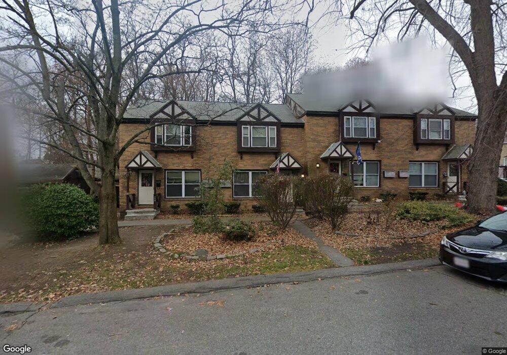
256 Barker Ave Lowell, MA 01850
Centralville NeighborhoodEstimated Value: $269,000 - $313,000
2
Beds
2
Baths
928
Sq Ft
$312/Sq Ft
Est. Value
About This Home
This home is located at 256 Barker Ave, Lowell, MA 01850 and is currently estimated at $289,719, approximately $312 per square foot. 256 Barker Ave is a home located in Middlesex County with nearby schools including Greenhalge Elementary School, S. Christa McAuliffe Elementary School, and Moody Elementary School.
Ownership History
Date
Name
Owned For
Owner Type
Purchase Details
Closed on
Oct 31, 2023
Sold by
Barker Avenue T and Diversified Mgr Rb Llc Tr
Bought by
Barker Ave Tprop Llc
Current Estimated Value
Home Financials for this Owner
Home Financials are based on the most recent Mortgage that was taken out on this home.
Original Mortgage
$5,774,000
Outstanding Balance
$5,673,082
Interest Rate
7.49%
Mortgage Type
Stand Alone Refi Refinance Of Original Loan
Estimated Equity
-$5,383,363
Create a Home Valuation Report for This Property
The Home Valuation Report is an in-depth analysis detailing your home's value as well as a comparison with similar homes in the area
Home Values in the Area
Average Home Value in this Area
Purchase History
| Date | Buyer | Sale Price | Title Company |
|---|---|---|---|
| Barker Ave Tprop Llc | -- | None Available | |
| Barker Ave Tprop Llc | -- | None Available |
Source: Public Records
Mortgage History
| Date | Status | Borrower | Loan Amount |
|---|---|---|---|
| Open | Barker Ave Tprop Llc | $5,774,000 | |
| Closed | Barker Ave Tprop Llc | $5,774,000 |
Source: Public Records
Tax History
| Year | Tax Paid | Tax Assessment Tax Assessment Total Assessment is a certain percentage of the fair market value that is determined by local assessors to be the total taxable value of land and additions on the property. | Land | Improvement |
|---|---|---|---|---|
| 2025 | $2,360 | $205,600 | $0 | $205,600 |
| 2024 | $2,225 | $186,800 | $0 | $186,800 |
| 2023 | $2,049 | $165,000 | $0 | $165,000 |
| 2022 | $1,947 | $153,400 | $0 | $153,400 |
| 2021 | $1,851 | $137,500 | $0 | $137,500 |
| 2020 | $1,778 | $133,100 | $0 | $133,100 |
| 2019 | $1,737 | $123,700 | $0 | $123,700 |
| 2018 | $1,633 | $113,500 | $0 | $113,500 |
| 2017 | $1,408 | $94,400 | $0 | $94,400 |
| 2016 | $1,333 | $87,900 | $0 | $87,900 |
| 2015 | $1,333 | $86,100 | $0 | $86,100 |
| 2013 | $1,357 | $90,400 | $0 | $90,400 |
Source: Public Records
Map
Nearby Homes
- 345 Hildreth St Unit 14
- 367 Hildreth St Unit 14
- 23 18th St
- 417 Hildreth St Unit 30
- 35 Whitney Ave Unit 33
- 15 Dana St
- 175 Willard St Unit 9
- 26 Farmland Rd Unit C
- 18 May St
- 40 Arlington Ave
- 551 Hildreth St Unit 10
- 1391 Bridge St
- 700 Robbins Ave Unit 6
- 668 Robbins Ave Unit 1
- 106 Methuen St Unit B
- 69 Arlington St
- 99 W 6th St
- 27 Bunker Hill Ave
- 16 Peabody Ave
- 75 Sladen St
- 264 Barker Ave
- 262 Barker Ave
- 258 Barker Ave
- 260 Barker Ave
- 256 Barker Ave Unit TH
- 266 Barker Ave
- 266 Barker Ave Unit 1 266
- 266 Barker Ave Unit 1
- 268 Barker Ave
- 273 Barker Ave Unit 24
- 273 Barker Ave Unit 23
- 273 Barker Ave Unit 22
- 273 Barker Ave Unit 21
- 273 Barker Ave Unit 20
- 273 Barker Ave Unit 19
- 273 Barker Ave Unit 18
- 273 Barker Ave Unit 17
- 273 Barker Ave Unit 16
- 273 Barker Ave Unit 15
- 273 Barker Ave Unit 14
Your Personal Tour Guide
Ask me questions while you tour the home.