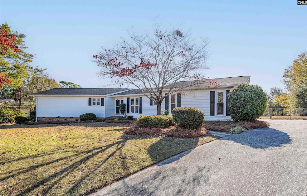
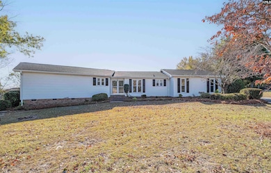
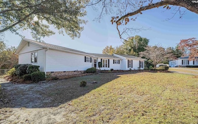
256 Calcutta Dr West Columbia, SC 29172
Pine Ridge NeighborhoodEstimated payment $1,658/month
Highlights
- Very Popular Property
- Traditional Architecture
- Granite Countertops
- 1.01 Acre Lot
- Bonus Room
- No HOA
About This Home
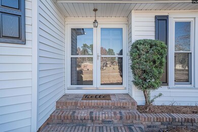
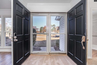
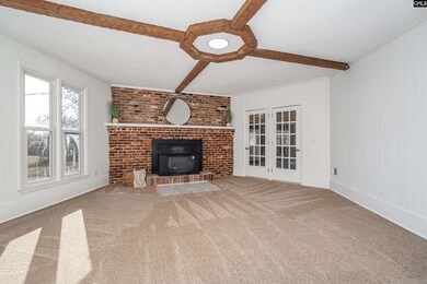
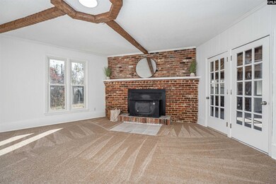
Welcome to your next home in Charwood subdivision of West Columbia! NO HOA, on an ACRE! This one level beauty is freshly renovated and ready for its new owner. The home is the opposite of "cookie cutter" with loads of character and charm.Upon entry you will notice new flooring and paint throughout the home. The step down living room boasts of a grandiose brick fireplace, high ceilings and beams. There is a formal dining room with built-ins, a walk-in pantry and laundry room with storage.The kitchen has white cabinets, new pulls and sink, new granite and stainless steel appliances.To the left of the home there are three private bedrooms. The Master Suite is expansive with plenty of room for a King-size bedroom suite and sitting area. The bathrooms are fully updated with functionality in mind.There is a 600 sqft bonus room off the back of the house that is heated and cooled with stunning wood ceilings. The space makes an excellent man cave, play room or additional living space.This two car garage has ample storage with built-ins and a useful utility closet. There is ample room for guest parking or large families.The backyard is a dream for privacy! No pesky restrictions, fully fenced-in and situated on an acre lot. Roof was fully replaced in 2024!Close to interstates, zoned for Lexington Two schools and a short drive from Charwood Country Club!Do not miss out on this opportunity! Disclaimer: CMLS has not reviewed and, therefore, does not endorse vendors who may appear in listings.
Home Details
Home Type
- Single Family
Est. Annual Taxes
- $301
Year Built
- Built in 1975
Lot Details
- 1.01 Acre Lot
- Back Yard Fenced
- Chain Link Fence
Parking
- 2 Car Garage
Home Design
- Traditional Architecture
- Vinyl Construction Material
Interior Spaces
- 2,413 Sq Ft Home
- 1-Story Property
- Built-In Features
- Beamed Ceilings
- Fireplace Features Masonry
- French Doors
- Great Room with Fireplace
- Sunken Living Room
- Bonus Room
- Crawl Space
- Fire and Smoke Detector
Kitchen
- Eat-In Kitchen
- Walk-In Pantry
- Free-Standing Range
- Dishwasher
- Granite Countertops
Flooring
- Carpet
- Laminate
Bedrooms and Bathrooms
- 3 Bedrooms
- Dual Closets
- 2 Full Bathrooms
Laundry
- Laundry Room
- Laundry on main level
- Electric Dryer Hookup
Schools
- Wood Elementary School
- Pine Ridge Middle School
- Airport High School
Utilities
- Central Heating and Cooling System
- Septic System
Community Details
- No Home Owners Association
- Charwood Subdivision
Map
Home Values in the Area
Average Home Value in this Area
Tax History
| Year | Tax Paid | Tax Assessment Tax Assessment Total Assessment is a certain percentage of the fair market value that is determined by local assessors to be the total taxable value of land and additions on the property. | Land | Improvement |
|---|---|---|---|---|
| 2024 | $301 | $4,955 | $840 | $4,115 |
| 2023 | $301 | $4,955 | $840 | $4,115 |
| 2022 | $307 | $4,955 | $840 | $4,115 |
| 2020 | $307 | $4,955 | $840 | $4,115 |
| 2019 | $251 | $4,514 | $720 | $3,794 |
| 2018 | $658 | $4,514 | $720 | $3,794 |
| 2017 | $633 | $4,514 | $720 | $3,794 |
| 2016 | $651 | $4,514 | $720 | $3,794 |
| 2014 | $496 | $5,024 | $920 | $4,104 |
| 2013 | -- | $5,020 | $920 | $4,100 |
Property History
| Date | Event | Price | List to Sale | Price per Sq Ft |
|---|---|---|---|---|
| 11/15/2025 11/15/25 | For Sale | $309,999 | -- | $128 / Sq Ft |
Purchase History
| Date | Type | Sale Price | Title Company |
|---|---|---|---|
| Deed | $175,000 | None Listed On Document | |
| Deed | $120,000 | None Listed On Document | |
| Deed | $120,000 | None Listed On Document | |
| Deed Of Distribution | -- | None Listed On Document | |
| Deed Of Distribution | -- | None Listed On Document | |
| Interfamily Deed Transfer | -- | None Available |
Mortgage History
| Date | Status | Loan Amount | Loan Type |
|---|---|---|---|
| Open | $201,250 | Construction | |
| Previous Owner | $103,444 | Purchase Money Mortgage |
Source: Consolidated MLS (Columbia MLS)
MLS Number: 621788
APN: 007920-02-016
Disclaimer: Certain information contained herein is derived from information provided by parties other than Homes.com. All information provided is deemed reliable, but is not guaranteed to be accurate and should be independently verified.
![]() IDX information is provided exclusively for personal, non-commercial use, and may not be used for any purpose other than to identify prospective properties consumers may be interested in purchasing. Information is deemed reliable but not guaranteed.
IDX information is provided exclusively for personal, non-commercial use, and may not be used for any purpose other than to identify prospective properties consumers may be interested in purchasing. Information is deemed reliable but not guaranteed.
- 273 Sandy Valley Ct
- 342 Calcutta Dr
- 204 Calcutta Dr
- 107 Bunker Dr
- 1916 Capitol View Rd
- 2020 Sandy Run Dr
- 3035 Bachman Rd
- 2105 Sandy Run Dr
- 2108 Oak Top Dr
- 2140 Sandy Run Dr
- 2128 Glenn Rd
- Crane Plan at The Village at Glenn Hills
- Dickenson Plan at The Village at Glenn Hills
- Frost Plan at The Village at Glenn Hills
- Anderson Plan at The Village at Glenn Hills
- Emerson Plan at The Village at Glenn Hills
- Oakmont Plan at The Village at Glenn Hills
- 112 Preakness Ct
- 100 Marilyn Ln
- 268 Shumpert Rd
- 212 Long Iron Ct
- 762 Lansford Bay Dr
- 419 Old Plantation Dr
- 161 Kings Tree Acres Dr
- 2309 Windsor Rd
- 1206 N Eden Dr
- 1137 Fort Congaree Trail
- 120 Pinehurst Ct
- 1803 Frink St
- 2805 Shadblow Ln
- 1 Bradley Ct
- 2894 Elm St
- 146 Villa Ct Unit B
- 2807 Julius Felder St
- 2520 Stonehenge Dr
- 2336 James St
- 1136 Charlotte St
- 1513 Dunbar Rd
- 346 Sprahler St
- 119 E Woods Ct
