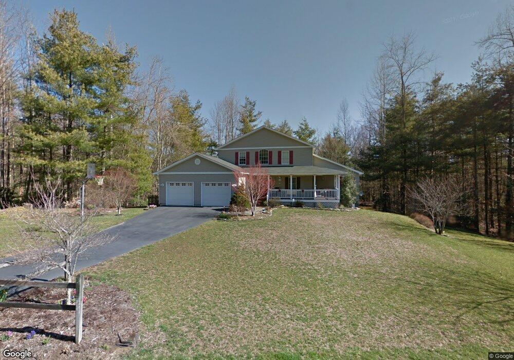
256 Greenfield Cir Brevard, NC 28712
Estimated Value: $753,570 - $1,035,000
3
Beds
3
Baths
2,423
Sq Ft
$354/Sq Ft
Est. Value
About This Home
This home is located at 256 Greenfield Cir, Brevard, NC 28712 and is currently estimated at $856,643, approximately $353 per square foot. 256 Greenfield Cir is a home located in Transylvania County.
Ownership History
Date
Name
Owned For
Owner Type
Purchase Details
Closed on
Sep 6, 2012
Sold by
Barger R Norris and Barger Jill W
Bought by
Barger Ralph N and Barger Jill W
Current Estimated Value
Home Financials for this Owner
Home Financials are based on the most recent Mortgage that was taken out on this home.
Original Mortgage
$160,000
Interest Rate
3.53%
Mortgage Type
New Conventional
Purchase Details
Closed on
Jul 12, 2007
Sold by
White Squirrel Llc
Bought by
Arias Jack and Arias Marguerite
Purchase Details
Closed on
Jan 1, 1998
Bought by
Barger Ralph N and Barger Jill W
Create a Home Valuation Report for This Property
The Home Valuation Report is an in-depth analysis detailing your home's value as well as a comparison with similar homes in the area
Home Values in the Area
Average Home Value in this Area
Purchase History
| Date | Buyer | Sale Price | Title Company |
|---|---|---|---|
| Barger Ralph N | -- | None Available | |
| Arias Jack | -- | None Available | |
| Barger Ralph N | $31,000 | -- |
Source: Public Records
Mortgage History
| Date | Status | Borrower | Loan Amount |
|---|---|---|---|
| Closed | Barger Ralph N | $160,000 |
Source: Public Records
Tax History Compared to Growth
Tax History
| Year | Tax Paid | Tax Assessment Tax Assessment Total Assessment is a certain percentage of the fair market value that is determined by local assessors to be the total taxable value of land and additions on the property. | Land | Improvement |
|---|---|---|---|---|
| 2025 | $3,528 | $734,330 | $110,720 | $623,610 |
| 2024 | $2,993 | $454,610 | $100,000 | $354,610 |
| 2023 | $2,993 | $454,610 | $100,000 | $354,610 |
| 2022 | $2,993 | $454,610 | $100,000 | $354,610 |
| 2021 | $2,970 | $454,610 | $100,000 | $354,610 |
| 2020 | $2,497 | $358,700 | $0 | $0 |
| 2019 | $2,479 | $358,700 | $0 | $0 |
| 2018 | $2,132 | $358,700 | $0 | $0 |
| 2017 | $2,108 | $358,700 | $0 | $0 |
| 2016 | $2,074 | $358,700 | $0 | $0 |
| 2015 | $1,564 | $350,480 | $70,000 | $280,480 |
| 2014 | $1,564 | $350,480 | $70,000 | $280,480 |
Source: Public Records
Map
Nearby Homes
- 514 Eagle Lake Dr
- 141 Danny Ln
- 130 Greenfield Cir
- 99999 Small Creek Rd Unit 4
- 1881 Becky Mountain Rd
- 266 Lost Mine Trail Unit L602
- 30 Banks Ln
- TBD Rock Face Rd Unit L299
- 658 Johnson Rd
- TBD Mystic Mountain Dr
- 999 Mulberry Cir
- 14 Long Branch Rd Unit 14
- 28 Big Rock Rd
- TBD Juniper Ln
- 228 Double Falls Rd
- TBD Still Branch Rd Unit L20
- 132 Connestee Rd
- Lot 9 Galax Ln Unit 9
- 99999 Thunder Rd
- Lot 131 Thunder Rd
- TBD Lot 814 Greenfield Cir Unit Lot 814
- 106 Eagle Lake Dr
- 1905 Eagle Lake Dr
- 212 Greenfield Cir
- 169 Eagle Lake Dr Unit 169
- 341 Eagle Lake Dr
- 153 Eagle Lake Dr
- Lot 124 C Lake Ln Unit 124 C
- Lot 124 C Lake Ln Unit Lot 124 C Lake Lane
- L151 Eagle Lake Dr
- 289 Eagle Lake Dr Unit 107
- Lot 132 Eagle Lake Dr
- L-153 Eagle Lake Dri Eagle Lake Dr
- L161 Eagle Lake Dr Unit 161
- Lot 101 Eagle Lake Dr Unit 101
- Lot 132 Eagle Lake Dr Unit 132
- Lot 163A Eagle Lake Dr Unit 163A
- 0 Eagle Lake Dr Unit 132
- 1809 Eagle Lake Dr
- 170 Eagle Lake Dr Unit 170