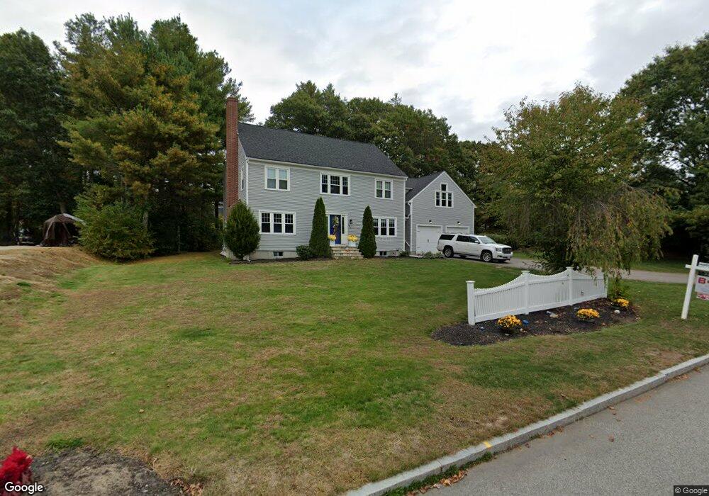
256 Olde Forge Rd Hanover, MA 02339
Estimated Value: $998,464 - $1,133,000
4
Beds
3
Baths
2,844
Sq Ft
$378/Sq Ft
Est. Value
About This Home
This home is located at 256 Olde Forge Rd, Hanover, MA 02339 and is currently estimated at $1,073,866, approximately $377 per square foot. 256 Olde Forge Rd is a home located in Plymouth County with nearby schools including Hanover High School.
Ownership History
Date
Name
Owned For
Owner Type
Purchase Details
Closed on
May 28, 2020
Sold by
Logn Casey J and Logn Emily A
Bought by
Avram Alexandra and Avram Natalia
Current Estimated Value
Purchase Details
Closed on
Jan 19, 2010
Sold by
Landers Bruce A and Landers Debra J
Bought by
Logan Casey J and Logan Emily A
Purchase Details
Closed on
Jan 20, 1999
Sold by
Cook Mark R and Page-Cook Kathleen
Bought by
Landers Bruce A and Landers Debra J
Purchase Details
Closed on
Sep 3, 1992
Sold by
Olde Forge Bldrs Inc
Bought by
Cook Mrk R and Cook Kathleen P
Create a Home Valuation Report for This Property
The Home Valuation Report is an in-depth analysis detailing your home's value as well as a comparison with similar homes in the area
Home Values in the Area
Average Home Value in this Area
Purchase History
| Date | Buyer | Sale Price | Title Company |
|---|---|---|---|
| Avram Alexandra | $669,000 | None Available | |
| Avram Alexandra | $669,000 | None Available | |
| Logan Casey J | $459,500 | -- | |
| Logan Casey J | $459,500 | -- | |
| Landers Bruce A | $288,000 | -- | |
| Cook Mrk R | $76,000 | -- | |
| Cook Mrk R | $76,000 | -- |
Source: Public Records
Mortgage History
| Date | Status | Borrower | Loan Amount |
|---|---|---|---|
| Previous Owner | Cook Mrk R | $180,000 | |
| Previous Owner | Cook Mrk R | $218,000 |
Source: Public Records
Tax History
| Year | Tax Paid | Tax Assessment Tax Assessment Total Assessment is a certain percentage of the fair market value that is determined by local assessors to be the total taxable value of land and additions on the property. | Land | Improvement |
|---|---|---|---|---|
| 2025 | $11,274 | $912,900 | $326,300 | $586,600 |
| 2024 | $10,988 | $855,800 | $326,300 | $529,500 |
| 2023 | $10,529 | $780,500 | $296,600 | $483,900 |
| 2022 | $10,503 | $688,700 | $247,200 | $441,500 |
| 2021 | $10,335 | $632,900 | $225,100 | $407,800 |
| 2020 | $10,026 | $614,700 | $225,100 | $389,600 |
| 2019 | $9,669 | $589,200 | $225,100 | $364,100 |
| 2018 | $9,000 | $552,800 | $225,100 | $327,700 |
| 2017 | $9,342 | $565,500 | $235,900 | $329,600 |
| 2016 | $9,044 | $536,400 | $214,300 | $322,100 |
| 2015 | $8,978 | $555,900 | $233,800 | $322,100 |
Source: Public Records
Map
Nearby Homes
- 17 Hayford Trail Unit 12
- 7 Hayford Trail Unit 12
- 5 Hayford Trail Unit 11
- 22 Howland Trail Unit 34
- 724 Whitman St
- 108 Waterford Dr
- 139 Fairwood Dr
- 168 Spring St
- 10 Birch Bottom Cir
- 10 Proud Foot Way
- Lot 5 Princeton Way
- 23 Live Oak Way
- 95 Tecumseh Dr
- 430 Brook Bend Rd
- 84 Liberty St
- 75 School St
- 5 Alpine St
- 26 Stonebridge Dr
- 561 Circuit St
- 696 Summer St
- 242 Olde Forge Rd
- 40 Wilder Ln
- 12 Wood Hollow Way
- 264 Olde Forge Rd
- 16 Wood Hollow Way
- 39 Wilder Ln
- 557 King St
- 10 Wood Hollow Way
- 228 Olde Forge Rd
- 225 Olde Forge Rd
- 278 Olde Forge Rd
- 8 Wood Hollow Way
- 7 Wood Hollow Way
- 9 Wood Hollow Way
- 275 Olde Forge Rd
- 24 Wilder Ln
- 23 Wilder Ln
- 5 Wood Hollow Way
- 216 Olde Forge Rd
- 79 Olde Forge Rd
Your Personal Tour Guide
Ask me questions while you tour the home.