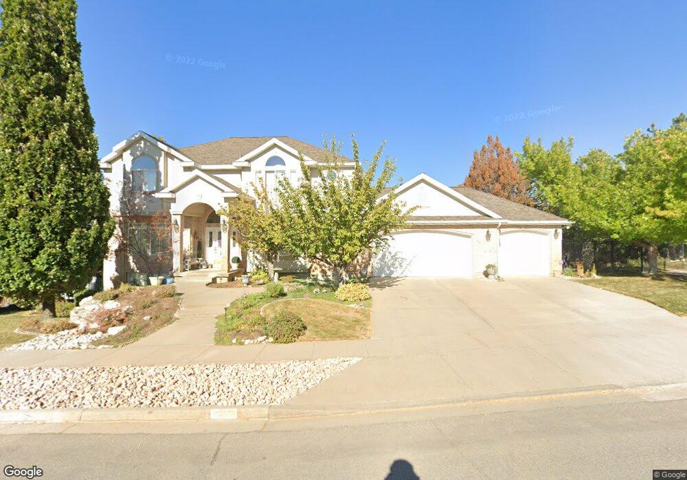
256 Sterling Dr Bountiful, UT 84010
Estimated Value: $853,813 - $1,056,000
5
Beds
4
Baths
3,152
Sq Ft
$301/Sq Ft
Est. Value
About This Home
This home is located at 256 Sterling Dr, Bountiful, UT 84010 and is currently estimated at $947,953, approximately $300 per square foot. 256 Sterling Dr is a home located in Davis County with nearby schools including Adelaide School, South Davis Junior High School, and Woods Cross High School.
Ownership History
Date
Name
Owned For
Owner Type
Purchase Details
Closed on
Mar 28, 2025
Sold by
Leanna Kenneth P and Leanna Willmore
Bought by
Kenneth And Leanna Willmore Joint Revocable T and Willmore
Current Estimated Value
Purchase Details
Closed on
Jun 29, 2007
Sold by
Willmore Kenneth P and Willmore Leanna
Bought by
Willmore Kenneth P and Willmore Leanna
Create a Home Valuation Report for This Property
The Home Valuation Report is an in-depth analysis detailing your home's value as well as a comparison with similar homes in the area
Purchase History
| Date | Buyer | Sale Price | Title Company |
|---|---|---|---|
| Kenneth And Leanna Willmore Joint Revocable T | -- | None Listed On Document | |
| Kenneth And Leanna Willmore Joint Revocable T | -- | None Listed On Document | |
| Willmore Kenneth P | -- | None Available |
Source: Public Records
Tax History
| Year | Tax Paid | Tax Assessment Tax Assessment Total Assessment is a certain percentage of the fair market value that is determined by local assessors to be the total taxable value of land and additions on the property. | Land | Improvement |
|---|---|---|---|---|
| 2025 | $5,497 | $515,900 | $169,563 | $346,337 |
| 2024 | $4,779 | $453,750 | $155,720 | $298,030 |
| 2023 | $4,693 | $805,000 | $290,524 | $514,476 |
| 2022 | $4,750 | $452,650 | $155,860 | $296,790 |
| 2021 | $4,251 | $620,000 | $232,366 | $387,634 |
| 2020 | $3,735 | $547,000 | $211,397 | $335,603 |
| 2019 | $3,953 | $571,000 | $149,651 | $421,349 |
| 2018 | $3,769 | $537,000 | $146,220 | $390,780 |
| 2016 | $2,952 | $235,950 | $58,739 | $177,211 |
| 2015 | $3,203 | $239,690 | $58,739 | $180,951 |
| 2014 | $3,756 | $290,354 | $58,739 | $231,615 |
| 2013 | -- | $251,166 | $76,935 | $174,231 |
Source: Public Records
Map
Nearby Homes
- 336 W 3500 S
- 1104 E Fairway Dr
- 294 Springridge Dr
- 3285 S Davis Blvd
- 8 E 3500 S
- 3716 S Oakridge Cir
- 136 E Fairway Dr
- 141 W 3100 S
- 468 W 3200 S
- 3279 Plum Tree Ln
- 3241 Plum Tree Ln
- 527 Applewood Dr
- 53 N Foxhill Rd
- 3126 Applewood Dr
- 310 N 675 E
- 90 Scenic Hills Cir
- 337 W 2900 S
- 652 W 3600 S
- 178 N Valley View Dr
- 3759 S Huntington Dr
- 265 Sterling Dr
- 284 Sterling Dr
- 251 Sterling Dr
- 226 Sterling Dr
- 229 Sterling Dr
- 279 W Sterling Cir
- 279 Sterling Dr
- 3737 Monarch Dr
- 205 Sterling Dr
- 3727 Monarch Dr
- 256 Monarch Dr
- 293 Sterling Dr
- 234 Monarch Dr
- 196 Sterling Dr
- 3717 Monarch Dr
- 3610 Coronation Way
- 3620 Coronation Way
- 3630 Coronation Way
- 212 Monarch Dr
- 189 Sterling Dr
Your Personal Tour Guide
Ask me questions while you tour the home.