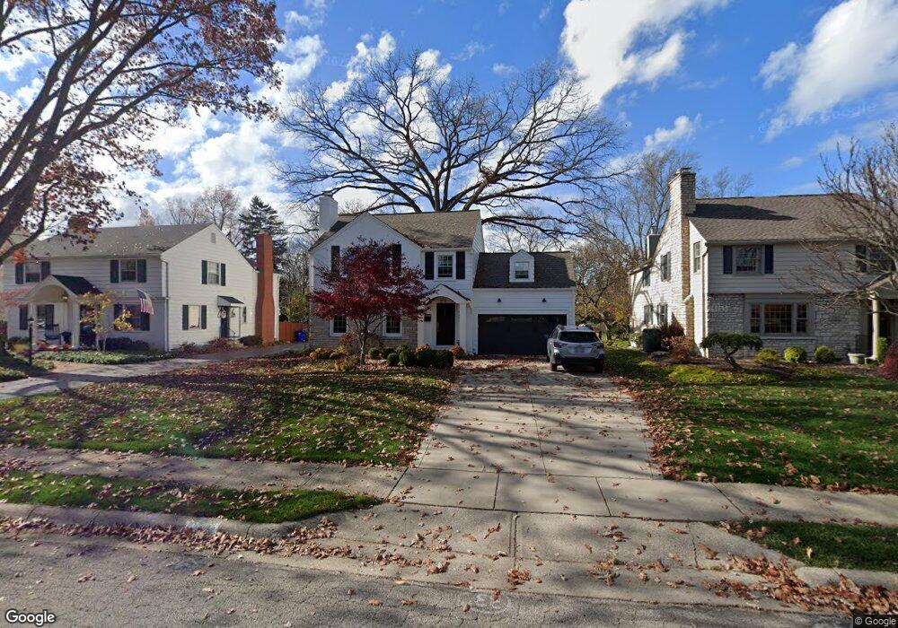
2561 Andover Rd Columbus, OH 43221
Estimated Value: $792,000 - $997,000
4
Beds
3
Baths
2,388
Sq Ft
$370/Sq Ft
Est. Value
About This Home
This home is located at 2561 Andover Rd, Columbus, OH 43221 and is currently estimated at $883,039, approximately $369 per square foot. 2561 Andover Rd is a home located in Franklin County with nearby schools including Tremont Elementary School, Jones Middle School, and Upper Arlington High School.
Ownership History
Date
Name
Owned For
Owner Type
Purchase Details
Closed on
Jan 26, 2018
Sold by
Ewing Dabniel E and Ewing Cynthia M
Bought by
Colburn Molly and Ewing Family Trust
Current Estimated Value
Purchase Details
Closed on
Sep 6, 1995
Sold by
Lane Frances A
Bought by
Ewing Daniel E and Ewing Cynthia M
Home Financials for this Owner
Home Financials are based on the most recent Mortgage that was taken out on this home.
Original Mortgage
$150,000
Interest Rate
7.76%
Mortgage Type
New Conventional
Purchase Details
Closed on
May 21, 1991
Create a Home Valuation Report for This Property
The Home Valuation Report is an in-depth analysis detailing your home's value as well as a comparison with similar homes in the area
Home Values in the Area
Average Home Value in this Area
Purchase History
We collect this data history from publicly available records. To have your information removed, we recommend requesting removal directly through your county’s website.
| Date | Buyer | Sale Price | Title Company |
|---|---|---|---|
| Colburn Molly | -- | None Available | |
| Ewing Daniel E | $230,000 | -- | |
| -- | -- | -- |
Source: Public Records
Mortgage History
We collect this data history from publicly available records. To have your information removed, we recommend requesting removal directly through your county’s website.
| Date | Status | Borrower | Loan Amount |
|---|---|---|---|
| Closed | Ewing Daniel E | $150,000 |
Source: Public Records
Tax History
| Year | Tax Paid | Tax Assessment Tax Assessment Total Assessment is a certain percentage of the fair market value that is determined by local assessors to be the total taxable value of land and additions on the property. | Land | Improvement |
|---|---|---|---|---|
| 2025 | $13,755 | $237,590 | $103,010 | $134,580 |
| 2024 | $13,755 | $237,590 | $103,010 | $134,580 |
| 2023 | $13,584 | $237,590 | $103,010 | $134,580 |
| 2022 | $13,611 | $194,780 | $49,560 | $145,220 |
| 2021 | $12,049 | $194,780 | $49,560 | $145,220 |
| 2020 | $11,345 | $185,050 | $49,560 | $135,490 |
| 2019 | $10,487 | $151,030 | $49,560 | $101,470 |
| 2018 | $10,028 | $151,030 | $49,560 | $101,470 |
| 2017 | $10,022 | $151,030 | $49,560 | $101,470 |
| 2016 | $9,651 | $145,960 | $53,520 | $92,440 |
| 2015 | $9,642 | $145,960 | $53,520 | $92,440 |
| 2014 | $9,653 | $145,960 | $53,520 | $92,440 |
| 2013 | $4,610 | $132,685 | $48,650 | $84,035 |
Source: Public Records
Map
Nearby Homes
- 2583 Wexford Rd
- 1923 Chatfield Rd
- 1869 Tewksbury Rd
- 2165 S Parkway Dr
- 2684 Westmont Blvd
- 2762 Tremont Rd
- 2208 Arlington Ave
- 1770 Harwitch Rd
- 1461 Ridgeview Rd
- 2301 Brixton Rd
- 1470 Cardiff Rd
- 1455 Berkshire Rd
- 3055 Tremont Rd
- 2028 Wyandotte Rd
- 1920 Edgemont Rd
- 2357 Dorset Rd
- 2869 N Star Rd
- 2406 Canterbury Rd
- 3071 Halesworth Rd
- 1872 Stanford Rd
- 2553 Andover Rd
- 2569 Andover Rd
- 2543 Andover Rd
- 2577 Andover Rd
- 2535 Andover Rd
- 2570 Berwyn Rd
- 2585 Andover Rd
- 2562 Berwyn Rd
- 2578 Berwyn Rd
- 2556 Andover Rd
- 2564 Andover Rd
- 2554 Berwyn Rd
- 2554 Berwyn Rd
- 2548 Andover Rd
- 2586 Berwyn Rd
- 2572 Andover Rd
- 2593 Andover Rd
- 2540 Andover Rd
- 2527 Andover Rd
- 2546 Berwyn Rd
Your Personal Tour Guide
Ask me questions while you tour the home.