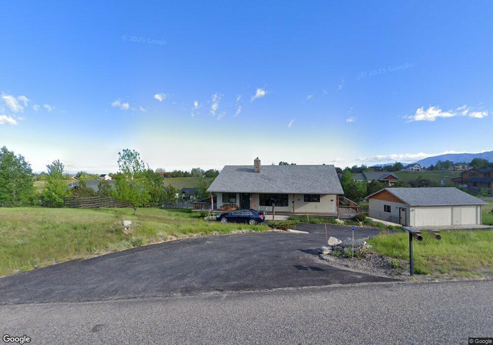
2561 Sentinel Dr Bozeman, MT 59715
Estimated Value: $1,191,000 - $2,013,000
4
Beds
4
Baths
1,974
Sq Ft
$766/Sq Ft
Est. Value
About This Home
This home is located at 2561 Sentinel Dr, Bozeman, MT 59715 and is currently estimated at $1,511,836, approximately $765 per square foot. 2561 Sentinel Dr is a home located in Gallatin County with nearby schools including Hawthorne Elementary School, Chief Joseph Middle School, and Gallatin High School.
Ownership History
Date
Name
Owned For
Owner Type
Purchase Details
Closed on
May 4, 2025
Sold by
Hash Gail
Bought by
Gove Hash Family Trust and Gove
Current Estimated Value
Purchase Details
Closed on
Feb 17, 2025
Sold by
Hash Bonnie W
Bought by
Hash Gail
Purchase Details
Closed on
Nov 27, 2024
Sold by
Qualified Personal Residence Trust Of Lo and Paules Brian
Bought by
Paules Brian and Paules Eric
Purchase Details
Closed on
Apr 5, 2021
Sold by
Hash Bonnie W
Bought by
Hash Bonnie W
Create a Home Valuation Report for This Property
The Home Valuation Report is an in-depth analysis detailing your home's value as well as a comparison with similar homes in the area
Purchase History
We collect this data history from publicly available records. To have your information removed, we recommend requesting removal directly through your county’s website.
| Date | Buyer | Sale Price | Title Company |
|---|---|---|---|
| Gove Hash Family Trust | -- | None Listed On Document | |
| Hash Gail | -- | Montana Title | |
| Paules Brian | -- | None Listed On Document | |
| Hash Bonnie W | -- | None Listed On Document |
Source: Public Records
Tax History
| Year | Tax Paid | Tax Assessment Tax Assessment Total Assessment is a certain percentage of the fair market value that is determined by local assessors to be the total taxable value of land and additions on the property. | Land | Improvement |
|---|---|---|---|---|
| 2025 | $4,950 | $1,209,000 | $0 | $0 |
| 2024 | $5,671 | $1,038,200 | $0 | $0 |
| 2023 | $5,464 | $1,038,200 | $0 | $0 |
| 2022 | $4,941 | $741,400 | $0 | $0 |
| 2021 | $5,486 | $741,400 | $0 | $0 |
| 2020 | $4,736 | $633,400 | $0 | $0 |
| 2019 | $4,661 | $633,400 | $0 | $0 |
| 2018 | $4,849 | $598,000 | $0 | $0 |
| 2017 | $4,645 | $598,000 | $0 | $0 |
| 2016 | $3,822 | $485,300 | $0 | $0 |
| 2015 | $3,811 | $485,300 | $0 | $0 |
| 2014 | $3,374 | $252,280 | $0 | $0 |
Source: Public Records
Map
Nearby Homes
- Lot 28 Cold Smoke Dr
- 2449 Turkey Red Ln
- 510 Cold Smoke
- 94 Snowcat Dr
- tbd Itana Cir
- 4574 Bannock Dr
- 685 Naya Nuki Dr
- TBD Sentinel Dr
- 103 Moon Shadow Dr
- 794 Naya-Nuki Dr
- 52 Moon Shadow Dr
- 4925 Itana Cir
- 65 Naya-Nuki Dr
- 334 Sky Crest Dr
- 749 Summer Ridge Rd
- 2915 Branding Iron Rd
- 7611 Sypes Canyon Rd
- 1028 Summer Ridge Rd
- 25 Summer Ridge Rd
- 555 Glory Ln
- 250 Evening Star Ln
- Lot 77 Evening Star Ln
- 257 Evening Star Ln
- Lot 80 Evening Star Ln
- 259 Evening Star Ln
- tbd Evening Star Ln
- Lt 74 Evening Star
- 10 Red Cloud Place
- 4 Red Cloud Place
- 9D Red Cloud Place
- 9 Red Cloud Place Unit 10
- 3 Red Cloud Place Unit 19
- 1A Red Cloud Place
- 1 Red Cloud Place
- 1 Red Cloud Place Unit 20
- 1B Red Cloud Place Unit 21
- 2622 Sentinel Dr
- 236 Evening Star Ln
- 239 Evening Star Ln
- 2724 Sentinel Dr
Your Personal Tour Guide
Ask me questions while you tour the home.