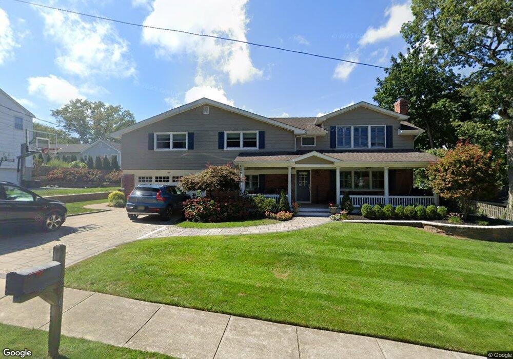
2561 Summit Rd Manasquan, NJ 08736
Estimated Value: $1,011,000 - $1,345,000
4
Beds
3
Baths
2,959
Sq Ft
$388/Sq Ft
Est. Value
About This Home
This home is located at 2561 Summit Rd, Manasquan, NJ 08736 and is currently estimated at $1,147,263, approximately $387 per square foot. 2561 Summit Rd is a home located in Monmouth County with nearby schools including Wall High School and The Brookside School.
Ownership History
Date
Name
Owned For
Owner Type
Purchase Details
Closed on
Apr 14, 2022
Sold by
Conforti Paul J and Conforti Danielle
Bought by
Conforti Paul J and Conforti Danielle D
Current Estimated Value
Purchase Details
Closed on
Jan 29, 1996
Sold by
Brady Paul
Bought by
Conforti Paul and Conforti Danielle
Home Financials for this Owner
Home Financials are based on the most recent Mortgage that was taken out on this home.
Original Mortgage
$150,000
Interest Rate
7.1%
Create a Home Valuation Report for This Property
The Home Valuation Report is an in-depth analysis detailing your home's value as well as a comparison with similar homes in the area
Home Values in the Area
Average Home Value in this Area
Purchase History
| Date | Buyer | Sale Price | Title Company |
|---|---|---|---|
| Conforti Paul J | -- | Dougherty Delia A | |
| Conforti Paul J | -- | None Listed On Document | |
| Conforti Paul | $200,000 | -- |
Source: Public Records
Mortgage History
| Date | Status | Borrower | Loan Amount |
|---|---|---|---|
| Previous Owner | Conforti Paul | $150,000 |
Source: Public Records
Tax History
| Year | Tax Paid | Tax Assessment Tax Assessment Total Assessment is a certain percentage of the fair market value that is determined by local assessors to be the total taxable value of land and additions on the property. | Land | Improvement |
|---|---|---|---|---|
| 2025 | $11,305 | $535,800 | $250,000 | $285,800 |
| 2024 | $10,968 | $535,800 | $250,000 | $285,800 |
| 2023 | $10,968 | $535,800 | $250,000 | $285,800 |
| 2022 | $10,700 | $535,800 | $250,000 | $285,800 |
| 2021 | $10,700 | $535,800 | $250,000 | $285,800 |
| 2020 | $10,571 | $535,800 | $250,000 | $285,800 |
| 2019 | $10,443 | $535,800 | $250,000 | $285,800 |
| 2018 | $10,352 | $535,800 | $250,000 | $285,800 |
| 2017 | $10,148 | $535,800 | $250,000 | $285,800 |
| 2016 | $9,934 | $535,800 | $250,000 | $285,800 |
| 2015 | $10,700 | $362,700 | $133,900 | $228,800 |
| 2014 | $10,316 | $357,700 | $130,000 | $227,700 |
Source: Public Records
Map
Nearby Homes
- 504 Old Bridge Rd
- 14 Lebanon Dr
- 432 Oval Rd
- 308 South St
- 1041 Oval Rd Unit 5
- 1215 Church St
- 816 Rathjen Rd
- 642 Rankin Rd
- 2513 Morningstar Rd
- 612 Union Ave
- 1533 Harvest Ln
- 846 William Dr
- 2526 Morningstar Rd
- 2409 Robin Way
- 2455 Dovetail Ct
- 1544 Harvest Ln
- 130 Union Ave
- 1551 Holly Blvd
- 607 Cherokee Ln
- 323-325 Fisk Ave
- 2557 Summit Rd
- 2565 Summit Rd
- 2552 Constance Dr
- 2550 Constance Dr
- 1217 Ivy Rd
- 2554 Constance Dr
- 1216 Ivy Rd
- 2553 Summit Rd
- 2548 Constance Dr
- 2569 Summit Rd
- 2568 Summit Rd
- 2558 Summit Rd
- 2556 Constance Dr
- 2553 Constance Dr
- 2563 Crestview Rd
- 2551 Constance Dr
- 2561 Crestview Rd
- 2570 Summit Rd
- 2565 Crestview Rd
- 2555 Constance Dr
Your Personal Tour Guide
Ask me questions while you tour the home.