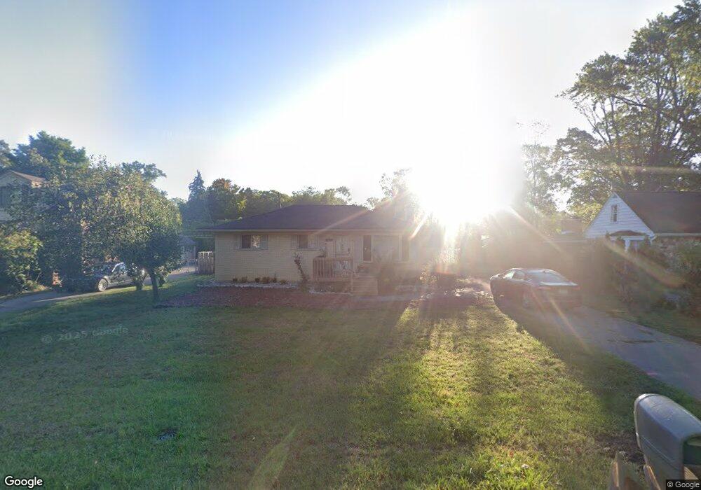
25670 Code Rd Southfield, MI 48033
Estimated Value: $217,063 - $270,000
3
Beds
2
Baths
1,352
Sq Ft
$179/Sq Ft
Est. Value
About This Home
This home is located at 25670 Code Rd, Southfield, MI 48033 and is currently estimated at $242,016, approximately $179 per square foot. 25670 Code Rd is a home located in Oakland County with nearby schools including Morris Adler Elementary School, Glenn W. Levey Middle School, and Faxon Academy.
Ownership History
Date
Name
Owned For
Owner Type
Purchase Details
Closed on
Jan 16, 2023
Sold by
Flowers Georgette
Bought by
Flowers Georgette
Current Estimated Value
Purchase Details
Closed on
Mar 27, 2006
Sold by
Hall Carolyn
Bought by
Flowers Robert and Flowers Georgette
Home Financials for this Owner
Home Financials are based on the most recent Mortgage that was taken out on this home.
Original Mortgage
$116,700
Interest Rate
6.37%
Mortgage Type
Purchase Money Mortgage
Purchase Details
Closed on
Apr 17, 2003
Sold by
U S Bank Na
Bought by
Hall Carolyn
Purchase Details
Closed on
Feb 19, 2002
Sold by
Smith Thomas J
Bought by
U S Bank
Purchase Details
Closed on
May 24, 1996
Sold by
Smith Thomas J
Bought by
Smith Thomas J
Create a Home Valuation Report for This Property
The Home Valuation Report is an in-depth analysis detailing your home's value as well as a comparison with similar homes in the area
Home Values in the Area
Average Home Value in this Area
Purchase History
| Date | Buyer | Sale Price | Title Company |
|---|---|---|---|
| Flowers Georgette | -- | -- | |
| Flowers Robert | $145,900 | Transaction Title | |
| Hall Carolyn | $130,000 | -- | |
| U S Bank | $139,900 | -- | |
| Smith Thomas J | -- | -- |
Source: Public Records
Mortgage History
| Date | Status | Borrower | Loan Amount |
|---|---|---|---|
| Previous Owner | Flowers Robert | $116,700 |
Source: Public Records
Tax History
| Year | Tax Paid | Tax Assessment Tax Assessment Total Assessment is a certain percentage of the fair market value that is determined by local assessors to be the total taxable value of land and additions on the property. | Land | Improvement |
|---|---|---|---|---|
| 2025 | $2,429 | $88,260 | $20,920 | $67,340 |
| 2022 | $2,064 | $85,300 | $13,620 | $71,680 |
| 2021 | $2,174 | $78,630 | $13,620 | $65,010 |
| 2020 | $1,903 | $71,290 | $11,840 | $59,450 |
| 2018 | $2,247 | $46,390 | $8,500 | $37,890 |
| 2015 | -- | $34,420 | $0 | $0 |
| 2014 | -- | $31,340 | $0 | $0 |
| 2011 | -- | $31,980 | $0 | $0 |
Source: Public Records
Map
Nearby Homes
- 25150 Briarbank Ave
- 25835 Lahser Rd Unit 5
- 25555 Lahser Rd Unit 15
- 25160 Lahser Rd
- 24818 Lois Ln
- 23409 Ranch Hill Dr W
- 22664 W 11 Mile Rd Unit 10
- 22465 Kenwyck Dr
- 21821 Concord St
- 21516 Mcclung Ave
- 21963 Deer Brook Dr Unit 1
- 21955 Deer Brook Dr Unit 3
- 21959 Deer Brook Dr Unit 2
- 21951 Deer Brook Dr Unit 4
- 22903 N Bellwood Dr
- 21812 Duns Scotus St Unit 7
- 23223 Bellwood Dr
- 24733 Primrose Ln
- 24642 Primrose Ln
- 24744 Cashmere Ct Unit 119
- 25680 Code Rd
- 25660 Code Rd
- 25690 Code Rd
- 25599 Briarbank Ave
- 22470 Charter St
- 25555 Briarbank Ave
- 25639 Briarbank Ave
- 25700 Code Rd
- 25679 Briarbank Ave
- 25671 Code Rd
- 25681 Code Rd
- 25525 Briarbank Ave
- 25655 Code Rd
- 25689 Code Rd
- 25761 Briarbank Ave
- 25720 Code Rd
- 25280 Code Rd
- 25695 Code Rd
- 25601 Code Rd
- 25801 Briarbank Ave
Your Personal Tour Guide
Ask me questions while you tour the home.