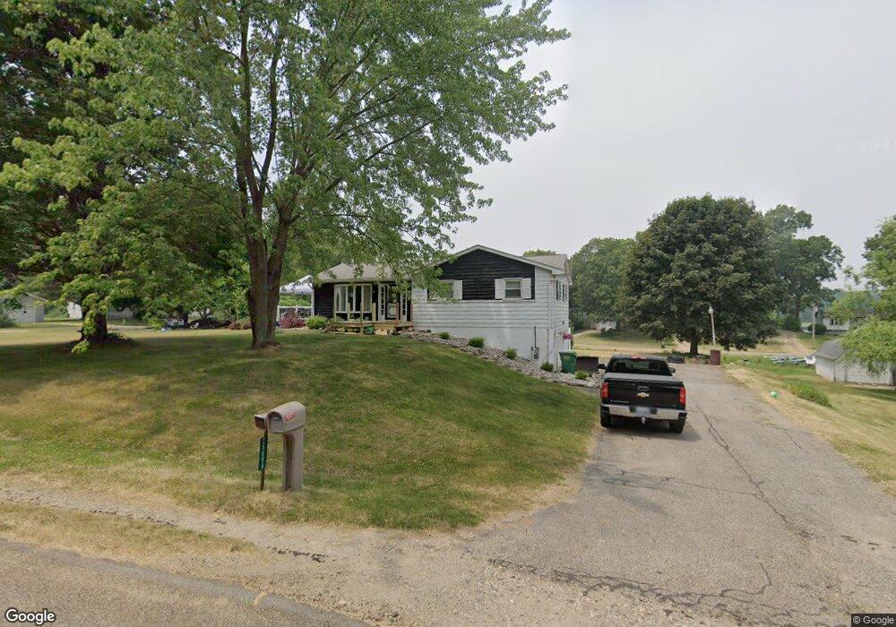
25696 Ottokee Dr Sturgis, MI 49091
Estimated Value: $55,000 - $163,000
--
Bed
--
Bath
--
Sq Ft
8,712
Sq Ft Lot
About This Home
This home is located at 25696 Ottokee Dr, Sturgis, MI 49091 and is currently estimated at $109,000. 25696 Ottokee Dr is a home located in St. Joseph County with nearby schools including Sturgis High School, Trinity Lutheran School, and New Dawn School.
Ownership History
Date
Name
Owned For
Owner Type
Purchase Details
Closed on
Oct 14, 2020
Sold by
Ratering Judith L
Bought by
Camburn Anna Rose and Camburn Patrick Andrew
Current Estimated Value
Purchase Details
Closed on
Aug 14, 2003
Sold by
Mingus Virginia
Bought by
Mingus Virginia Trust
Purchase Details
Closed on
Aug 6, 2003
Sold by
Mistretta Gasper Vincent Trust
Bought by
Mingus Virginia
Purchase Details
Closed on
Mar 10, 2003
Sold by
Mistretta G Vincent
Bought by
Mistretta G Vincent-Deceased
Purchase Details
Closed on
Sep 30, 2002
Sold by
Mistretta G Vincent-Deceased
Bought by
Mistretta Gasper Vincent Trust
Purchase Details
Closed on
Jan 1, 1901
Create a Home Valuation Report for This Property
The Home Valuation Report is an in-depth analysis detailing your home's value as well as a comparison with similar homes in the area
Home Values in the Area
Average Home Value in this Area
Purchase History
| Date | Buyer | Sale Price | Title Company |
|---|---|---|---|
| Camburn Anna Rose | -- | None Available | |
| Mingus Virginia Trust | -- | -- | |
| Mingus Virginia | -- | -- | |
| Mistretta G Vincent-Deceased | -- | -- | |
| Mistretta Gasper Vincent Trust | -- | -- | |
| -- | -- | -- |
Source: Public Records
Tax History Compared to Growth
Tax History
| Year | Tax Paid | Tax Assessment Tax Assessment Total Assessment is a certain percentage of the fair market value that is determined by local assessors to be the total taxable value of land and additions on the property. | Land | Improvement |
|---|---|---|---|---|
| 2025 | $110 | $5,400 | $5,400 | $0 |
| 2024 | $24 | $4,700 | $4,700 | $0 |
| 2023 | $23 | $2,400 | $2,400 | $0 |
| 2022 | $0 | $2,200 | $2,200 | $0 |
| 2021 | $76 | $2,000 | $2,000 | $0 |
| 2020 | $21 | $2,000 | $2,000 | $0 |
| 2019 | $21 | $2,000 | $2,000 | $0 |
| 2018 | $92 | $2,000 | $2,000 | $0 |
| 2017 | $93 | $2,000 | $2,000 | $0 |
| 2016 | -- | $2,000 | $2,000 | $0 |
| 2015 | -- | $1,700 | $1,700 | $0 |
| 2014 | -- | $1,800 | $1,800 | $0 |
| 2012 | -- | $2,500 | $2,500 | $0 |
Source: Public Records
Map
Nearby Homes
- VL2 Ottokee Dr
- VL1 Ottokee Dr
- 24920 Airline Rd
- 24624 Airline Rd
- 200 Broadus St
- 0 N Centerville St
- 708 N Centerville Rd
- 26865 Us Highway 12
- 600 Saint Joseph St
- 1016 Greenlawn Dr
- 908 Meadowlane Dr
- 206 N Park St
- 701 N Nottawa St
- 607 N Nottawa St
- 416 Sturgis St
- 607 George St
- 401 Devonshire Dr
- 69760 White School Rd
- 0 Deer Rd
- 612 N Prospect St
- 25696 Ottokee Dr
- 25696 Ottokee Dr
- 25728 Ottokee Dr
- 25736 Hiawatha Dr
- 67807 Thunderbird Dr
- 25725 Ottokee Dr
- 25903 Hiawatha Dr
- 25903 Hiawatha Dr
- 25753 Ottokee Dr
- 25939 Hiawatha Dr
- 25744 Hiawatha Dr
- 25744 Hiawatha Dr
- 67838 Thunderbird Dr
- 67838 Thunderbird Dr
- 25760 Airline Rd
- 25765 Ottokee Dr
- 67860 Thunderbird Dr
- 67941 Thunderbird Dr
- 67910 Thunderbird Dr
- 159 Hiawatha Dr