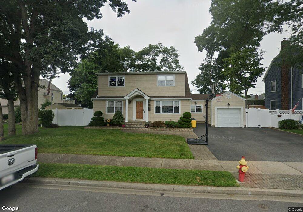
257 N Hawthorne St Massapequa, NY 11758
Estimated Value: $809,000 - $817,426
--
Bed
2
Baths
1,796
Sq Ft
$453/Sq Ft
Est. Value
About This Home
This home is located at 257 N Hawthorne St, Massapequa, NY 11758 and is currently estimated at $813,213, approximately $452 per square foot. 257 N Hawthorne St is a home located in Nassau County with nearby schools including Charles E. Schwarting School, Plainedge Middle School, and Plainedge Senior High School.
Ownership History
Date
Name
Owned For
Owner Type
Purchase Details
Closed on
Oct 22, 2010
Sold by
Hardiman Douglas and Anadolis Elpis
Bought by
Kraft Michael D and Kraft Caroline G
Current Estimated Value
Home Financials for this Owner
Home Financials are based on the most recent Mortgage that was taken out on this home.
Original Mortgage
$359,000
Outstanding Balance
$237,624
Interest Rate
4.41%
Mortgage Type
Unknown
Estimated Equity
$575,589
Purchase Details
Closed on
Apr 19, 2002
Sold by
Lo Basso Stephen
Bought by
Hardiman Douglas
Create a Home Valuation Report for This Property
The Home Valuation Report is an in-depth analysis detailing your home's value as well as a comparison with similar homes in the area
Home Values in the Area
Average Home Value in this Area
Purchase History
| Date | Buyer | Sale Price | Title Company |
|---|---|---|---|
| Kraft Michael D | $529,000 | -- | |
| Hardiman Douglas | $310,000 | Tim Dougherty |
Source: Public Records
Mortgage History
| Date | Status | Borrower | Loan Amount |
|---|---|---|---|
| Open | Kraft Michael D | $359,000 |
Source: Public Records
Tax History Compared to Growth
Tax History
| Year | Tax Paid | Tax Assessment Tax Assessment Total Assessment is a certain percentage of the fair market value that is determined by local assessors to be the total taxable value of land and additions on the property. | Land | Improvement |
|---|---|---|---|---|
| 2025 | $15,720 | $489 | $240 | $249 |
| 2024 | $4,760 | $521 | $256 | $265 |
| 2023 | $13,910 | $534 | $262 | $272 |
| 2022 | $13,910 | $542 | $266 | $276 |
| 2021 | $13,905 | $554 | $272 | $282 |
| 2020 | $14,588 | $699 | $682 | $17 |
| 2019 | $13,449 | $699 | $682 | $17 |
| 2018 | $12,489 | $699 | $0 | $0 |
| 2017 | $8,067 | $743 | $524 | $219 |
| 2016 | $11,890 | $967 | $682 | $285 |
| 2015 | $4,408 | $967 | $564 | $403 |
| 2014 | $4,408 | $967 | $564 | $403 |
| 2013 | $4,017 | $967 | $682 | $285 |
Source: Public Records
Map
Nearby Homes
- 282 N Oak St
- 530 N Oak St
- 530 N Hawthorne St
- 240 Wyngate Dr
- 254 N Richmond Ave
- 344 N Hickory St
- 227 N Walnut St
- 558 N Hawthorne St
- 7 Crocus Dr
- 5 Webster Ave
- 956 N Park Ave
- 203 N Manhattan Ave
- 267 N Elm St
- 212 N Cedar St
- 598 N Suffolk Ave
- 3 Rutland Rd
- 101 Toronto Ave
- 121 Ontario Ave
- 214 N Cedar St
- 250 N Poplar St
- 255 N Hawthorne St
- 259 N Hawthorne St
- 266 N Oak St
- 270 N Oak St
- 252 N Hawthorne St
- 253 N Hawthorne St Unit B
- 253 N Hawthorne St
- 262 N Oak St
- 272 N Oak St
- 261 N Hawthorne St
- 250 N Hawthorne St
- 258 N Oak St
- 258 N Oak St
- 256 N Hawthorne St
- 254 N Hawthorne St
- 274 N Oak St
- 248 N Hawthorne St
- 263 N Hawthorne St
- 283 N Queens Ave
- 258 N Hawthorne St