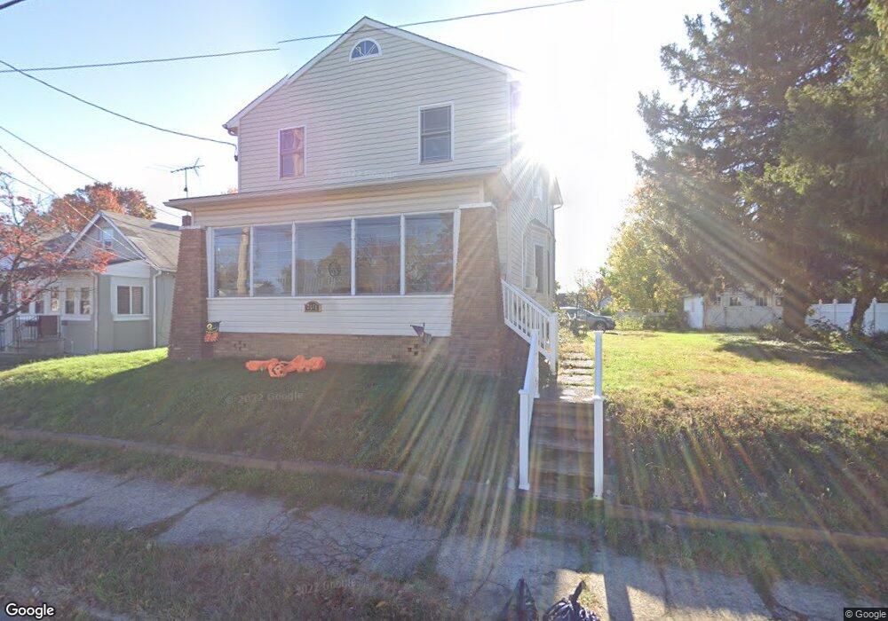
2571 Liberty St Trenton, NJ 08629
Estimated Value: $380,530 - $527,000
--
Bed
--
Bath
2,014
Sq Ft
$220/Sq Ft
Est. Value
About This Home
This home is located at 2571 Liberty St, Trenton, NJ 08629 and is currently estimated at $442,133, approximately $219 per square foot. 2571 Liberty St is a home located in Mercer County with nearby schools including Kuser Elementary School, Emily C. Reynolds Middle School, and Steinert - Hamilton High East.
Ownership History
Date
Name
Owned For
Owner Type
Purchase Details
Closed on
Jan 3, 2000
Sold by
Farber Eva
Bought by
Mayer Constance
Current Estimated Value
Home Financials for this Owner
Home Financials are based on the most recent Mortgage that was taken out on this home.
Original Mortgage
$109,250
Outstanding Balance
$34,372
Interest Rate
7.71%
Mortgage Type
Purchase Money Mortgage
Estimated Equity
$407,761
Purchase Details
Closed on
Nov 6, 1998
Sold by
Forrester Floyd
Bought by
Farbar Eva
Create a Home Valuation Report for This Property
The Home Valuation Report is an in-depth analysis detailing your home's value as well as a comparison with similar homes in the area
Home Values in the Area
Average Home Value in this Area
Purchase History
| Date | Buyer | Sale Price | Title Company |
|---|---|---|---|
| Mayer Constance | $115,000 | -- | |
| Farbar Eva | $32,000 | -- |
Source: Public Records
Mortgage History
| Date | Status | Borrower | Loan Amount |
|---|---|---|---|
| Open | Mayer Constance | $109,250 |
Source: Public Records
Tax History Compared to Growth
Tax History
| Year | Tax Paid | Tax Assessment Tax Assessment Total Assessment is a certain percentage of the fair market value that is determined by local assessors to be the total taxable value of land and additions on the property. | Land | Improvement |
|---|---|---|---|---|
| 2025 | $7,274 | $206,400 | $43,800 | $162,600 |
| 2024 | $6,817 | $206,400 | $43,800 | $162,600 |
| 2023 | $6,817 | $206,400 | $43,800 | $162,600 |
| 2022 | $6,710 | $206,400 | $43,800 | $162,600 |
| 2021 | $7,705 | $206,400 | $43,800 | $162,600 |
| 2020 | $6,962 | $206,400 | $43,800 | $162,600 |
| 2019 | $6,780 | $206,400 | $43,800 | $162,600 |
| 2018 | $6,704 | $206,400 | $43,800 | $162,600 |
| 2017 | $6,361 | $206,400 | $43,800 | $162,600 |
| 2016 | $5,678 | $210,000 | $47,400 | $162,600 |
| 2015 | $6,132 | $126,200 | $28,900 | $97,300 |
| 2014 | $6,034 | $126,200 | $28,900 | $97,300 |
Source: Public Records
Map
Nearby Homes
- 235 Darcy Ave
- 1427 Hamilton Ave
- 20 Charlotte Ave
- 618 Atlantic Ave
- 51 Charlotte Ave
- 61 Leuckel Ave
- 1524 Elizabeth Ave
- 20 Leuckel Ave
- 144 Beal St
- 25 Brook Ln
- 448 Lynwood Ave
- 480 S Logan Ave
- 19 Scammel Ave
- 657 S Olden Ave
- 631 S Olden Ave
- 176 Pope Ave
- 125 Edwin Ave
- 127 Bentley Ave
- 365 Cleveland Ave
- 541 Emmett Ave
- 2571 Liberty St
- 2577 Liberty St
- 2601 Liberty St
- 2607 Liberty St
- 2551 Liberty St Unit 3
- 2551 Liberty St Unit 4
- 2551 Liberty St
- 2551 Liberty St Unit 2
- 2609 Liberty St
- 2552 Liberty St
- 2568 Liberty St
- 2600 Liberty St
- 2560 Liberty St
- 2545 Liberty St
- 2548 Liberty St
- 2611 Liberty St
- 25 Steward St
- 2544 Liberty St
- 27 Steward St
- 2614 Liberty St