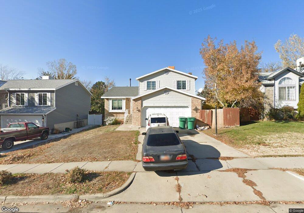
2575 N 1100 W Layton, UT 84041
Estimated Value: $451,000 - $508,000
5
Beds
4
Baths
2,386
Sq Ft
$204/Sq Ft
Est. Value
About This Home
This home is located at 2575 N 1100 W, Layton, UT 84041 and is currently estimated at $485,723, approximately $203 per square foot. 2575 N 1100 W is a home located in Davis County with nearby schools including Lincoln Elementary School, North Layton Junior High School, and Northridge High School.
Ownership History
Date
Name
Owned For
Owner Type
Purchase Details
Closed on
May 27, 2014
Sold by
Secretary Of Hud
Bought by
Francom Matthew
Current Estimated Value
Home Financials for this Owner
Home Financials are based on the most recent Mortgage that was taken out on this home.
Original Mortgage
$126,750
Outstanding Balance
$96,518
Interest Rate
4.23%
Mortgage Type
New Conventional
Estimated Equity
$389,205
Purchase Details
Closed on
Aug 27, 2013
Sold by
Mitchell Lane R and Villalobos Bianca R
Bought by
Phh Mortgage Corp
Purchase Details
Closed on
Aug 23, 2013
Sold by
Phh Mortgage Corp
Bought by
The Secretary Of Hud
Purchase Details
Closed on
Oct 27, 2009
Sold by
Smith Richard B and Smith Janice R
Bought by
Mitchell Lane R and Villalobos Bianca R
Create a Home Valuation Report for This Property
The Home Valuation Report is an in-depth analysis detailing your home's value as well as a comparison with similar homes in the area
Home Values in the Area
Average Home Value in this Area
Purchase History
| Date | Buyer | Sale Price | Title Company |
|---|---|---|---|
| Francom Matthew | -- | Cornerstone Title Ins Agency | |
| Phh Mortgage Corp | $188,938 | None Available | |
| The Secretary Of Hud | -- | None Available | |
| Mitchell Lane R | -- | Meridian Title Company |
Source: Public Records
Mortgage History
| Date | Status | Borrower | Loan Amount |
|---|---|---|---|
| Open | Francom Matthew | $126,750 |
Source: Public Records
Tax History Compared to Growth
Tax History
| Year | Tax Paid | Tax Assessment Tax Assessment Total Assessment is a certain percentage of the fair market value that is determined by local assessors to be the total taxable value of land and additions on the property. | Land | Improvement |
|---|---|---|---|---|
| 2024 | $2,216 | $234,300 | $102,610 | $131,690 |
| 2023 | $2,227 | $415,000 | $129,836 | $285,164 |
| 2022 | $2,304 | $233,200 | $66,274 | $166,926 |
| 2021 | $2,060 | $311,000 | $86,997 | $224,003 |
| 2020 | $1,851 | $268,000 | $75,671 | $192,329 |
| 2019 | $1,854 | $263,000 | $74,193 | $188,807 |
| 2018 | $1,657 | $236,000 | $74,193 | $161,807 |
| 2016 | $1,502 | $110,330 | $22,084 | $88,246 |
| 2015 | $1,432 | $99,880 | $22,084 | $77,796 |
| 2014 | $1,546 | $110,198 | $22,084 | $88,114 |
| 2013 | -- | $99,113 | $20,680 | $78,433 |
Source: Public Records
Map
Nearby Homes
- 2402 N 725 W
- 2887 N 1175 W
- 2378 N 675 W
- 2949 N 1175 W
- 781 W 2150 N
- 850 S 1650 E Unit D
- 1548 E 925 S
- 709 W Highway 193
- 2211 N 525 W
- 2875 N Hill Field Rd Unit 58
- 2875 N Hill Field Rd Unit 17
- 2875 N Hill Field Rd Unit 62
- 2187 N 450 W
- 1606 W 1960 N
- 1665 W 1960 N
- 65 Sunset Dr
- 63 Sunset Dr
- 1208 Valhalla Dr
- 86 Atherton Way
- 1094 N Angel St W