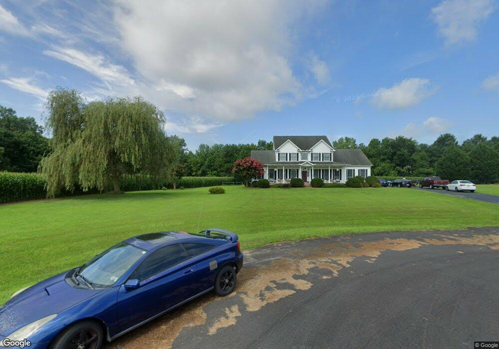
258 Upland Ln Centreville, MD 21617
Estimated Value: $715,603 - $783,000
4
Beds
3
Baths
3,553
Sq Ft
$210/Sq Ft
Est. Value
About This Home
This home is located at 258 Upland Ln, Centreville, MD 21617 and is currently estimated at $744,651, approximately $209 per square foot. 258 Upland Ln is a home located in Queen Anne's County with nearby schools including Centreville Elementary School, Kennard Elementary School, and Centreville Middle School.
Ownership History
Date
Name
Owned For
Owner Type
Purchase Details
Closed on
Nov 7, 2022
Sold by
Fox Charles W
Bought by
Fox Family Trust
Current Estimated Value
Purchase Details
Closed on
Dec 1, 2004
Sold by
Weese Development Corporation
Bought by
Fox Charles W and Fox Charles W Darlene N,
Purchase Details
Closed on
Nov 17, 2004
Sold by
Hollingsworth Farms Llc
Bought by
Weese Development Corporation
Create a Home Valuation Report for This Property
The Home Valuation Report is an in-depth analysis detailing your home's value as well as a comparison with similar homes in the area
Home Values in the Area
Average Home Value in this Area
Purchase History
| Date | Buyer | Sale Price | Title Company |
|---|---|---|---|
| Fox Family Trust | -- | -- | |
| Fox Family Trust | -- | None Listed On Document | |
| Fox Charles W | $160,000 | -- | |
| Weese Development Corporation | $143,100 | -- |
Source: Public Records
Mortgage History
| Date | Status | Borrower | Loan Amount |
|---|---|---|---|
| Closed | Fox Charles W | -- |
Source: Public Records
Tax History Compared to Growth
Tax History
| Year | Tax Paid | Tax Assessment Tax Assessment Total Assessment is a certain percentage of the fair market value that is determined by local assessors to be the total taxable value of land and additions on the property. | Land | Improvement |
|---|---|---|---|---|
| 2025 | $4,741 | $555,600 | $82,500 | $473,100 |
| 2024 | $4,498 | $511,200 | $0 | $0 |
| 2023 | $4,262 | $466,800 | $0 | $0 |
| 2022 | $4,039 | $422,400 | $82,500 | $339,900 |
| 2021 | $3,948 | $413,867 | $0 | $0 |
| 2020 | $3,948 | $405,333 | $0 | $0 |
| 2019 | $3,866 | $396,800 | $82,500 | $314,300 |
| 2018 | $3,866 | $396,800 | $82,500 | $314,300 |
| 2017 | $3,866 | $396,800 | $0 | $0 |
| 2016 | -- | $455,700 | $0 | $0 |
| 2015 | $2,120 | $450,033 | $0 | $0 |
| 2014 | $2,120 | $444,367 | $0 | $0 |
Source: Public Records
Map
Nearby Homes
- 112 Echo Ln
- 217 Austin Ct
- 129 Thicket Ct
- 107 Thicket Ct
- 219 Songbird Ln
- 272 Granny Branch Rd
- 252 Granny Branch Rd
- 111 Pleasant Springs Dr
- 325 Twin Meadows Farm Ln
- Merion Plan at Meadow Creek
- Windermere Plan at Meadow Creek
- Doral Plan at Meadow Creek
- Sawgrass Plan at Meadow Creek
- Pinehurst Plan at Meadow Creek
- Congressional Plan at Meadow Creek
- 116 Pasture Ct
- 104 Pasture Ct
- 122 Lently Farm Ln
- 415 Twin Meadows Farm Ln
- 331 Old Line Dr