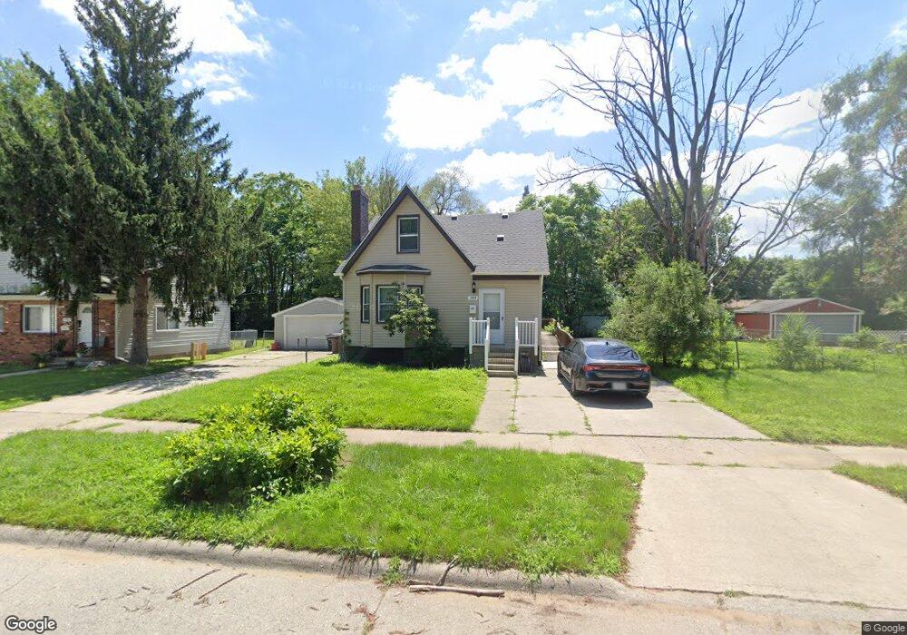
25849 Stanford St Inkster, MI 48141
Estimated Value: $106,000 - $344,867
4
Beds
1
Bath
1,108
Sq Ft
$155/Sq Ft
Est. Value
About This Home
This home is located at 25849 Stanford St, Inkster, MI 48141 and is currently estimated at $171,217, approximately $154 per square foot. 25849 Stanford St is a home located in Wayne County with nearby schools including West Village Academy, Quest Charter Academy, and Peterson-Warren Academy.
Ownership History
Date
Name
Owned For
Owner Type
Purchase Details
Closed on
Feb 8, 2017
Sold by
Sabree Eric R
Bought by
Wayne County Land Bank
Current Estimated Value
Purchase Details
Closed on
May 20, 2016
Sold by
Brown Kenneth
Bought by
Porter Monica L
Purchase Details
Closed on
Nov 20, 2015
Sold by
Treasurer Of The Charter County Of Wayne
Bought by
Brown Kenneth
Purchase Details
Closed on
Oct 16, 2002
Sold by
Orzer Spencer
Bought by
Hines Terrell
Create a Home Valuation Report for This Property
The Home Valuation Report is an in-depth analysis detailing your home's value as well as a comparison with similar homes in the area
Home Values in the Area
Average Home Value in this Area
Purchase History
| Date | Buyer | Sale Price | Title Company |
|---|---|---|---|
| Wayne County Land Bank | -- | None Available | |
| Porter Monica L | -- | None Available | |
| Brown Kenneth | $500 | None Available | |
| Hines Terrell | $70,000 | -- |
Source: Public Records
Tax History Compared to Growth
Tax History
| Year | Tax Paid | Tax Assessment Tax Assessment Total Assessment is a certain percentage of the fair market value that is determined by local assessors to be the total taxable value of land and additions on the property. | Land | Improvement |
|---|---|---|---|---|
| 2025 | $1,057 | $47,500 | $0 | $0 |
| 2024 | $1,057 | $38,300 | $0 | $0 |
| 2023 | $1,021 | $30,500 | $0 | $0 |
| 2022 | $1,486 | $25,100 | $0 | $0 |
| 2021 | $1,546 | $22,700 | $0 | $0 |
| 2020 | $1,512 | $19,100 | $0 | $0 |
| 2019 | $1,456 | $16,400 | $0 | $0 |
| 2018 | $974 | $15,500 | $0 | $0 |
| 2017 | $791 | $14,900 | $0 | $0 |
| 2016 | $1,420 | $15,200 | $0 | $0 |
| 2015 | $1,720 | $17,200 | $0 | $0 |
| 2013 | $2,160 | $21,600 | $0 | $0 |
| 2012 | $3,597 | $23,800 | $1,700 | $22,100 |
Source: Public Records
Map
Nearby Homes
- 25866 Andover St
- 25895 Annapolis St
- 26159 Stanford St
- 26202 Colgate St
- 0000 Ross Ross St
- 26231 Andover St
- 25474 McDonald St
- 26225 McDonald St
- 25243 Lehigh St
- 25926 Powers Ave
- 25212 Lehigh St
- 26439 Hopkins St
- 26458 Hopkins St
- 26106 Powers Ave
- 25628 Powers Ave
- 25118 Lehigh St
- 25085 Colgate St
- 26206 Kitch St
- 4110 John Daly St
- 26419 Carlysle St
- 25865 Stanford St
- 25837 Stanford St
- 25907 Stanford St
- 25906 Lehigh St
- 25842 Lehigh St
- 25916 Lehigh St
- 25915 Stanford St
- 25834 Lehigh St
- 25926 Lehigh St
- 25936 Lehigh St
- 4218 Beech Daly Rd
- 4218 Beech Daly Rd
- 25866 Stanford St
- 25931 Stanford St
- 4110 Beech Daly Rd
- 25986 Lehigh St
- 25906 Stanford St
- 25943 Stanford St
- 25994 Lehigh St
- 25955 Stanford St