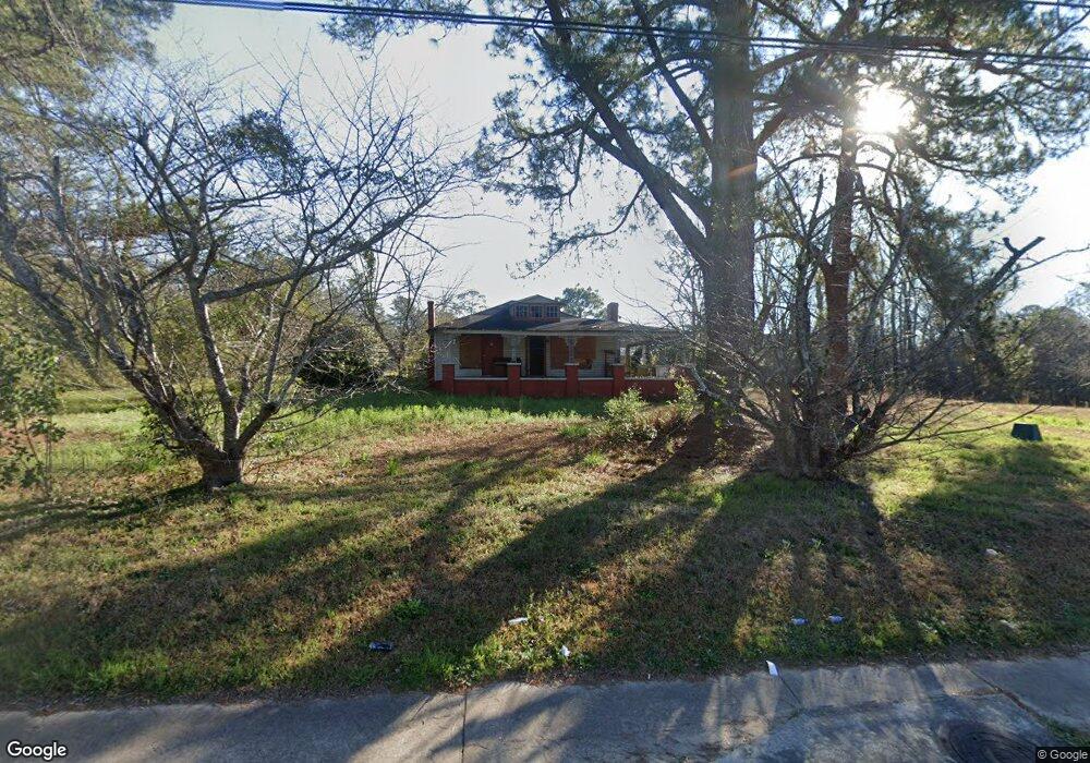
2585 New Clinton Rd Macon, GA 31211
Estimated Value: $54,000 - $98,000
4
Beds
3
Baths
1,516
Sq Ft
$48/Sq Ft
Est. Value
About This Home
This home is located at 2585 New Clinton Rd, Macon, GA 31211 and is currently estimated at $73,017, approximately $48 per square foot. 2585 New Clinton Rd is a home located in Bibb County with nearby schools including Martin Luther King Jr. Elementary School, Appling Middle School, and Northeast High School.
Ownership History
Date
Name
Owned For
Owner Type
Purchase Details
Closed on
Dec 4, 2024
Sold by
Charles Tcheno
Bought by
Pierre Dalf Thomas Rober
Current Estimated Value
Purchase Details
Closed on
Jun 23, 2021
Sold by
Exchange Bank
Bought by
Burney Tara Oshea and Burney Hansel
Purchase Details
Closed on
Jun 16, 2021
Sold by
Burney Tara Oshea and Burney Hansel
Bought by
Denasty Florette and Denasty Charles Teheno
Purchase Details
Closed on
Jan 21, 2009
Sold by
Carswell Barbara Harris
Bought by
Burney Tara Oshea and Burney Hansel
Home Financials for this Owner
Home Financials are based on the most recent Mortgage that was taken out on this home.
Original Mortgage
$100,000
Interest Rate
5.43%
Mortgage Type
Unknown
Purchase Details
Closed on
May 30, 2003
Bought by
Carswell Barbara Harris
Create a Home Valuation Report for This Property
The Home Valuation Report is an in-depth analysis detailing your home's value as well as a comparison with similar homes in the area
Home Values in the Area
Average Home Value in this Area
Purchase History
| Date | Buyer | Sale Price | Title Company |
|---|---|---|---|
| Pierre Dalf Thomas Rober | $60,000 | None Listed On Document | |
| Pierre Dalf Thomas Rober | $60,000 | None Listed On Document | |
| Burney Tara Oshea | -- | None Available | |
| Denasty Florette | $35,000 | None Available | |
| Burney Tara Oshea | $60,000 | None Available | |
| Carswell Barbara Harris | $68,000 | -- |
Source: Public Records
Mortgage History
| Date | Status | Borrower | Loan Amount |
|---|---|---|---|
| Previous Owner | Burney Tara Oshea | $100,000 |
Source: Public Records
Tax History Compared to Growth
Tax History
| Year | Tax Paid | Tax Assessment Tax Assessment Total Assessment is a certain percentage of the fair market value that is determined by local assessors to be the total taxable value of land and additions on the property. | Land | Improvement |
|---|---|---|---|---|
| 2025 | $606 | $24,644 | $4,140 | $20,504 |
| 2024 | $626 | $24,644 | $4,140 | $20,504 |
| 2023 | $626 | $24,644 | $4,140 | $20,504 |
| 2022 | $485 | $16,006 | $7,683 | $8,323 |
| 2021 | $724 | $19,049 | $6,999 | $12,050 |
| 2020 | $685 | $17,631 | $6,999 | $10,632 |
| 2019 | $690 | $17,631 | $6,999 | $10,632 |
| 2018 | $1,468 | $21,484 | $6,999 | $14,485 |
| 2017 | $805 | $21,484 | $6,999 | $14,485 |
| 2016 | $743 | $21,484 | $6,999 | $14,485 |
| 2015 | $1,052 | $21,484 | $6,999 | $14,485 |
| 2014 | $1,631 | $28,952 | $10,193 | $18,758 |
Source: Public Records
Map
Nearby Homes
- 2792 Skyline Dr
- 2630 Pauladale Dr
- 2815 New Clinton Rd
- 2458 Tredway Dr
- 2371 Kensington Rd
- 240 Neptune Ct
- 2557 Hyde Park Rd
- 2229 New Clinton Rd
- 3154 Bethune Ave
- 131 Sun Valley Dr
- 3048 Bethune Ave
- 135 Sun Valley Dr
- 3128 Commodore Dr
- 2761 Walnut Creek Rd
- 2954 Tyler Place
- 2146 Melton Ave
- 2130 New Clinton Rd
- 3145 Pasadena Dr
- 2940 Shurling Dr
- 2066 Melton Ave
- 2615 New Clinton Rd
- 2580 New Clinton Rd
- 2590 New Clinton Rd
- 2230 Greenwood Dr
- 2240 Greenwood Dr
- 2621 New Clinton Rd
- 2176 Bayswater Rd
- 2610 New Clinton Rd
- 2250 Greenwood Dr
- 2173 Knightsbridge Rd
- 2166 Bayswater Rd
- 2176 Knightsbridge Rd
- 2262 Greenwood Dr
- 2653 New Clinton Rd
- 2168 Knightsbridge Rd
- 2646 New Clinton Rd
- 2575 Northmore Dr
- 2158 Bayswater Rd
- 2157 Knightsbridge Rd
- 2160 Knightsbridge Rd