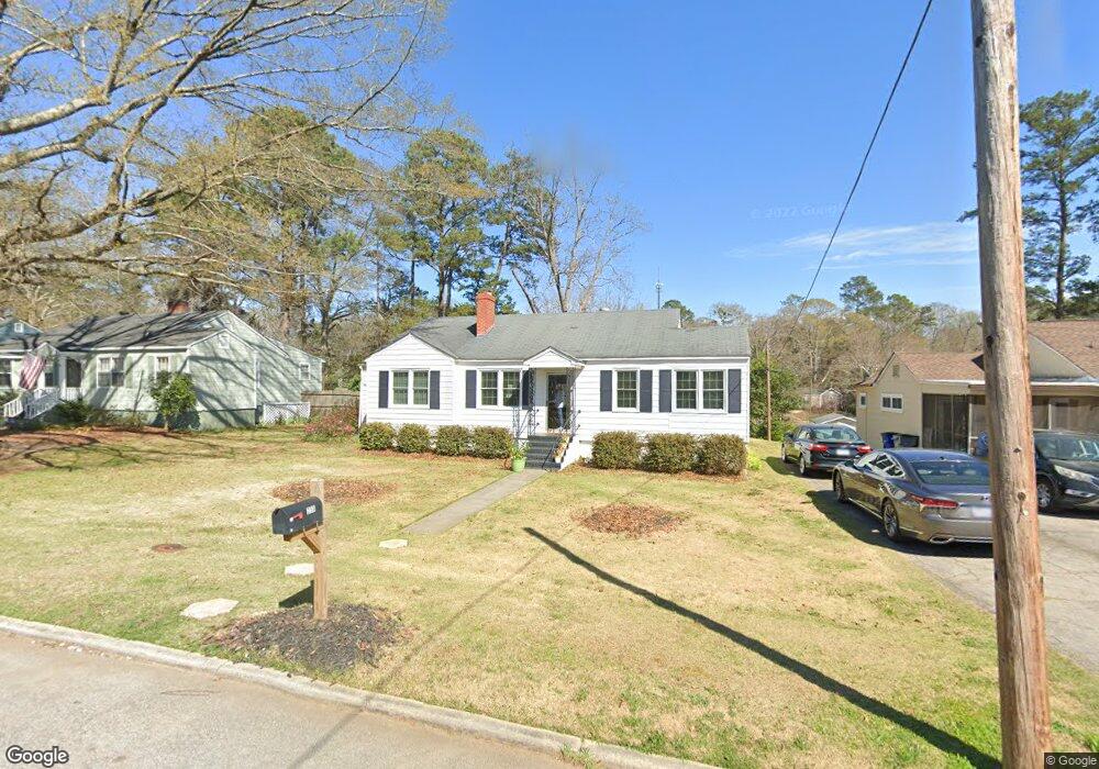
259 Beechwood Cir Unit 7 & 10 Lagrange, GA 30240
Estimated Value: $202,000 - $261,000
4
Beds
2
Baths
1,541
Sq Ft
$153/Sq Ft
Est. Value
About This Home
This home is located at 259 Beechwood Cir Unit 7 & 10, Lagrange, GA 30240 and is currently estimated at $235,896, approximately $153 per square foot. 259 Beechwood Cir Unit 7 & 10 is a home located in Troup County with nearby schools including Franklin Forest Elementary School, Hollis Hand Elementary School, and Ethel W. Kight Elementary School.
Ownership History
Date
Name
Owned For
Owner Type
Purchase Details
Closed on
Aug 28, 2020
Sold by
Cooper Eugene E
Bought by
Hill Alicia B
Current Estimated Value
Home Financials for this Owner
Home Financials are based on the most recent Mortgage that was taken out on this home.
Original Mortgage
$128,000
Outstanding Balance
$88,962
Interest Rate
2.9%
Mortgage Type
New Conventional
Estimated Equity
$146,934
Purchase Details
Closed on
Mar 8, 1983
Sold by
Harvey H Cooper
Bought by
Cooper May Belle E
Purchase Details
Closed on
Mar 1, 1983
Sold by
May Belle Cooper
Bought by
Harvey H Cooper
Purchase Details
Closed on
Jan 1, 1948
Sold by
Beechwood Hts
Bought by
May Belle Cooper
Create a Home Valuation Report for This Property
The Home Valuation Report is an in-depth analysis detailing your home's value as well as a comparison with similar homes in the area
Home Values in the Area
Average Home Value in this Area
Purchase History
| Date | Buyer | Sale Price | Title Company |
|---|---|---|---|
| Hill Alicia B | $135,000 | -- | |
| Cooper May Belle E | -- | -- | |
| Harvey H Cooper | -- | -- | |
| May Belle Cooper | -- | -- |
Source: Public Records
Mortgage History
| Date | Status | Borrower | Loan Amount |
|---|---|---|---|
| Open | Hill Alicia B | $128,000 |
Source: Public Records
Tax History Compared to Growth
Tax History
| Year | Tax Paid | Tax Assessment Tax Assessment Total Assessment is a certain percentage of the fair market value that is determined by local assessors to be the total taxable value of land and additions on the property. | Land | Improvement |
|---|---|---|---|---|
| 2024 | $1,784 | $67,412 | $22,480 | $44,932 |
| 2023 | $1,848 | $67,744 | $22,480 | $45,264 |
| 2022 | $1,682 | $60,264 | $17,480 | $42,784 |
| 2021 | $1,629 | $55,188 | $17,480 | $37,708 |
| 2020 | $1,283 | $42,524 | $10,000 | $32,524 |
| 2019 | $1,237 | $41,024 | $10,000 | $31,024 |
| 2018 | $1,237 | $41,024 | $10,000 | $31,024 |
| 2017 | $935 | $40,956 | $10,000 | $30,956 |
| 2016 | $934 | $40,918 | $10,000 | $30,918 |
| 2015 | $935 | $40,918 | $10,000 | $30,918 |
| 2014 | $544 | $27,963 | $8,000 | $19,963 |
| 2013 | -- | $29,529 | $8,000 | $21,529 |
Source: Public Records
Map
Nearby Homes
- 109 Thomas St
- 219 Banks St
- 145 Turner St
- 0 Ridley Ave Unit 10550104
- 609 Ridley Ave
- 707 Ridley Ave
- 611 Ridley Ave
- 615 Ridley Ave
- 709 Ridley Ave
- 900 North St
- 408 Gordon St
- 110 Russell St
- 105 Saynor Cir
- 301 E Bacon St
- 748 Lakewood Dr
- 102 Ewing St
- 204 Colonial St
- 106 Ewing St
- 724 Camellia Dr
- 109 Dogwood Dr
- 259 Beechwood Cir
- 261 Beechwood Cir
- 257 Beechwood Cir Unit 11
- 257 Beechwood Cir
- 255 Beechwood Cir
- 101 Elm Dr
- 0 Beechwood Cir Unit 7305890
- 0 Beechwood Cir Unit 8403392
- 0 Beechwood Cir Unit 8213752
- 0 Beechwood Cir Unit 3204551
- 0 Beechwood Cir Unit 8274719
- 0 Beechwood Cir Unit 7206966
- 0 Beechwood Cir Unit 8369411
- 0 Beechwood Cir Unit 8250414
- 0 Beechwood Cir Unit 8055458
- 0 Beechwood Cir Unit 7464253
- 0 Beechwood Cir Unit 7408633
- 0 Beechwood Cir Unit 8819964
- 0 Beechwood Cir Unit 8398356
- 0 Beechwood Cir Unit 8735535