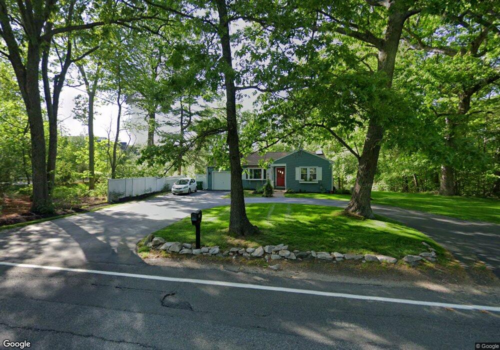
259 W Union St Ashland, MA 01721
Estimated Value: $528,000 - $593,000
3
Beds
1
Bath
1,387
Sq Ft
$408/Sq Ft
Est. Value
About This Home
This home is located at 259 W Union St, Ashland, MA 01721 and is currently estimated at $566,141, approximately $408 per square foot. 259 W Union St is a home located in Middlesex County with nearby schools including William Pittaway Elementary School, David Mindess Elementary School, and Henry E. Warren Elementary School.
Ownership History
Date
Name
Owned For
Owner Type
Purchase Details
Closed on
Nov 15, 2018
Sold by
Watson Elizabeth P Est
Bought by
Donovan Paul J
Current Estimated Value
Home Financials for this Owner
Home Financials are based on the most recent Mortgage that was taken out on this home.
Original Mortgage
$260,000
Outstanding Balance
$228,618
Interest Rate
4.8%
Mortgage Type
New Conventional
Estimated Equity
$337,523
Purchase Details
Closed on
Jan 31, 2014
Sold by
Ashland Woods Llc
Bought by
255 West Union Street
Purchase Details
Closed on
Dec 27, 1996
Sold by
Maher Paul J and Maher Mary
Bought by
Morgan John P
Home Financials for this Owner
Home Financials are based on the most recent Mortgage that was taken out on this home.
Original Mortgage
$116,850
Interest Rate
7.55%
Mortgage Type
Purchase Money Mortgage
Create a Home Valuation Report for This Property
The Home Valuation Report is an in-depth analysis detailing your home's value as well as a comparison with similar homes in the area
Home Values in the Area
Average Home Value in this Area
Purchase History
| Date | Buyer | Sale Price | Title Company |
|---|---|---|---|
| Donovan Paul J | $325,000 | -- | |
| 255 West Union Street | -- | -- | |
| Morgan John P | $123,000 | -- |
Source: Public Records
Mortgage History
| Date | Status | Borrower | Loan Amount |
|---|---|---|---|
| Open | Donovan Paul J | $260,000 | |
| Previous Owner | Morgan John P | $116,850 |
Source: Public Records
Tax History Compared to Growth
Tax History
| Year | Tax Paid | Tax Assessment Tax Assessment Total Assessment is a certain percentage of the fair market value that is determined by local assessors to be the total taxable value of land and additions on the property. | Land | Improvement |
|---|---|---|---|---|
| 2025 | $6,532 | $511,500 | $223,300 | $288,200 |
| 2024 | $6,443 | $486,600 | $223,300 | $263,300 |
| 2023 | $6,006 | $436,200 | $212,600 | $223,600 |
| 2022 | $6,155 | $387,600 | $193,200 | $194,400 |
| 2021 | $5,805 | $364,400 | $193,200 | $171,200 |
| 2020 | $5,559 | $344,000 | $196,600 | $147,400 |
| 2019 | $5,340 | $328,000 | $196,600 | $131,400 |
| 2018 | $5,187 | $312,300 | $194,600 | $117,700 |
| 2017 | $4,918 | $294,500 | $190,900 | $103,600 |
| 2016 | $4,661 | $274,200 | $186,000 | $88,200 |
| 2015 | $4,353 | $251,600 | $173,700 | $77,900 |
| 2014 | $4,323 | $248,600 | $155,100 | $93,500 |
Source: Public Records
Map
Nearby Homes
- 277 W Union St
- 277 W Union St
- 264 W Union St
- 268 W Union St
- 262 W Union St
- 272 W Union St
- 25 Woodland Rd
- 20 Woodland Rd
- 30 Woodland Rd
- 8 Linden St
- 8 Linden St Unit LEFT SIDE
- 1-2 Ashland Woods Ln
- 1-2 Ashland Woods Ln
- 229 W Union St
- 11 Walkup Ln
- 39 Woodland Rd
- 36 Woodland Rd
- 40 Woodland Rd
- 12 Walkup Ln
- 7 Walkup Ln