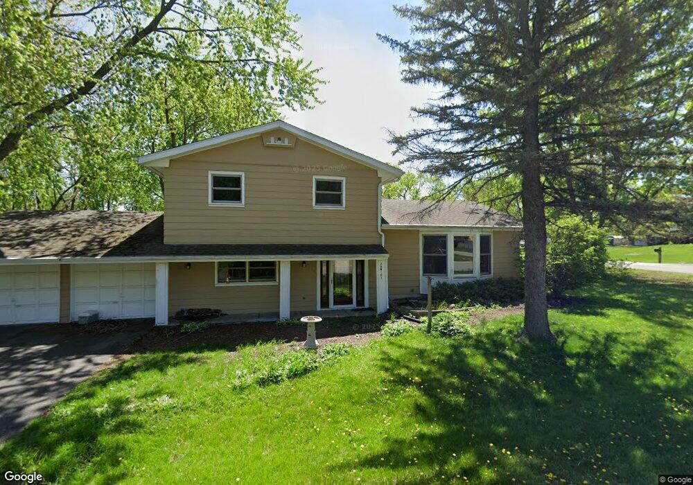
25W161 Armbrust Ave Wheaton, IL 60187
Northside-Wheaton NeighborhoodEstimated Value: $464,092 - $561,000
4
Beds
3
Baths
1,868
Sq Ft
$272/Sq Ft
Est. Value
About This Home
This home is located at 25W161 Armbrust Ave, Wheaton, IL 60187 and is currently estimated at $507,523, approximately $271 per square foot. 25W161 Armbrust Ave is a home located in DuPage County with nearby schools including Washington Elementary School, Franklin Middle School, and Wheaton North High School.
Ownership History
Date
Name
Owned For
Owner Type
Purchase Details
Closed on
Jun 17, 2011
Sold by
Breslin Roland M
Bought by
Carlson Joshua M C and Carlson Elizabeth A
Current Estimated Value
Home Financials for this Owner
Home Financials are based on the most recent Mortgage that was taken out on this home.
Original Mortgage
$197,600
Outstanding Balance
$136,221
Interest Rate
4.63%
Mortgage Type
New Conventional
Estimated Equity
$371,302
Purchase Details
Closed on
Jun 27, 2006
Sold by
Morehead Donald L and Morehead Nancy L
Bought by
Breslin Roland M
Home Financials for this Owner
Home Financials are based on the most recent Mortgage that was taken out on this home.
Original Mortgage
$208,000
Interest Rate
6.72%
Mortgage Type
Purchase Money Mortgage
Create a Home Valuation Report for This Property
The Home Valuation Report is an in-depth analysis detailing your home's value as well as a comparison with similar homes in the area
Home Values in the Area
Average Home Value in this Area
Purchase History
| Date | Buyer | Sale Price | Title Company |
|---|---|---|---|
| Carlson Joshua M C | $247,000 | Atg | |
| Breslin Roland M | $260,000 | Atg |
Source: Public Records
Mortgage History
| Date | Status | Borrower | Loan Amount |
|---|---|---|---|
| Open | Carlson Joshua M C | $197,600 | |
| Previous Owner | Breslin Roland M | $208,000 |
Source: Public Records
Tax History
| Year | Tax Paid | Tax Assessment Tax Assessment Total Assessment is a certain percentage of the fair market value that is determined by local assessors to be the total taxable value of land and additions on the property. | Land | Improvement |
|---|---|---|---|---|
| 2024 | $6,194 | $115,615 | $15,047 | $100,568 |
| 2023 | $5,914 | $106,420 | $13,850 | $92,570 |
| 2022 | $4,902 | $85,890 | $13,090 | $72,800 |
| 2021 | $4,710 | $83,850 | $12,780 | $71,070 |
| 2020 | $4,839 | $83,070 | $12,660 | $70,410 |
| 2019 | $4,710 | $80,880 | $12,330 | $68,550 |
| 2018 | $4,672 | $79,550 | $11,610 | $67,940 |
| 2017 | $4,590 | $76,610 | $11,180 | $65,430 |
| 2016 | $4,518 | $73,550 | $10,730 | $62,820 |
| 2015 | $4,477 | $70,170 | $10,240 | $59,930 |
| 2014 | $4,641 | $71,250 | $10,910 | $60,340 |
| 2013 | $4,501 | $71,460 | $10,940 | $60,520 |
Source: Public Records
Map
Nearby Homes
- 1310 N Carlton Ave
- N405 Gary Ave
- 933 Wheaton Oaks Dr
- 2018 N West St
- 1037 Wheaton Oaks Dr
- 1327 Shagbark Ln
- 111 W Prairie Ave
- 0 Ellis Ave
- 114 W Prairie Ave
- 1115 N Main St
- 0N105 Lot 1 Nepil Ave
- 0N105 Lot 2 Nepil Ave
- 524 Western Ave
- 1902 N Washington St
- 1N049 Mission Ct
- 405 Turf Ln
- 1920 N Washington St
- 1N248 Darling St
- Lot 11 Ellis Ave
- 606 W Franklin St
- 0N419 Morse St
- N376 Morse St
- 0N409 Morse St
- 25W160 Armbrust Ave
- 0N424 Morse St
- 0N422 Ellis Ave
- 0N406 Ellis Ave
- 25W146 Armbrust Ave
- 0N453 Morse St
- 25W200 Armbrust Ave
- 0N376 Morse St
- 0N461 Morse St
- 0N375 Morse St
- 0N456 Morse St
- 0N456 Ellis Ave
- N376 Ellis Ave
- 0N467 Morse St
- 0N423 Farwell St
- 25W220 Armbrust Ave
- 1550 N Morse St
Your Personal Tour Guide
Ask me questions while you tour the home.