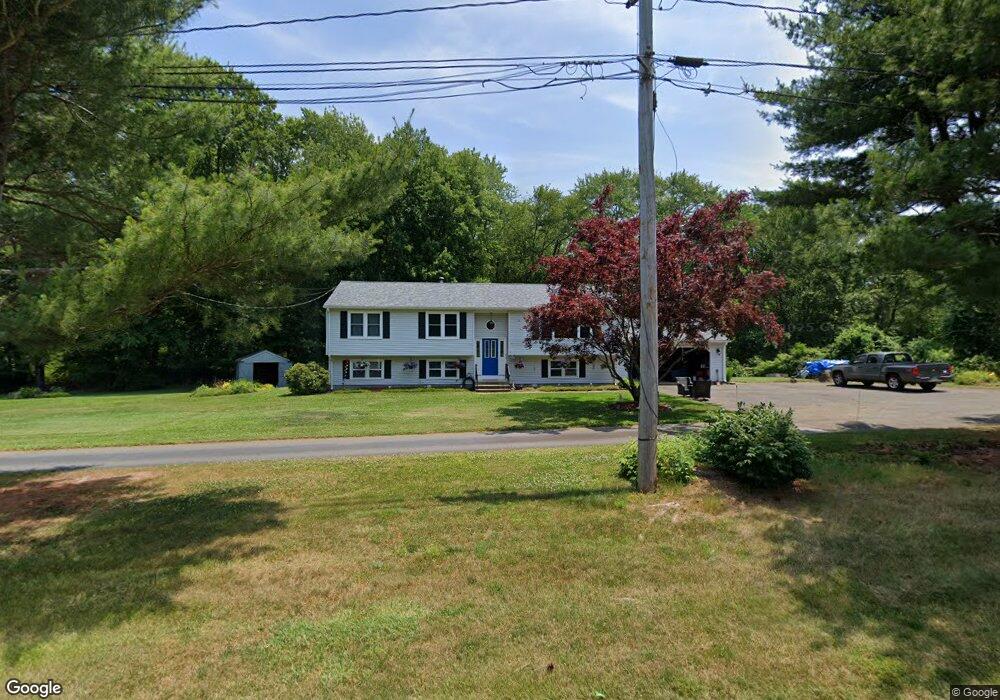
26 Anderson Rd Wallingford, CT 06492
Estimated Value: $491,193 - $624,000
4
Beds
3
Baths
1,340
Sq Ft
$420/Sq Ft
Est. Value
About This Home
This home is located at 26 Anderson Rd, Wallingford, CT 06492 and is currently estimated at $563,298, approximately $420 per square foot. 26 Anderson Rd is a home located in New Haven County with nearby schools including Evarts C. Stevens School, Pond Hill Elementary School, and Dag Hammarskjold Middle School.
Ownership History
Date
Name
Owned For
Owner Type
Purchase Details
Closed on
May 26, 2016
Sold by
Rousome Angela
Bought by
Rousome William
Current Estimated Value
Purchase Details
Closed on
Oct 6, 2015
Sold by
Dumark Michael and Dumark Maryann
Bought by
Rousome William and Rousome Angela
Purchase Details
Closed on
Sep 30, 2015
Sold by
Rousome William and Rousome Angela
Bought by
Dumark Maryann and Dumark Michael
Purchase Details
Closed on
Aug 29, 1991
Sold by
Marcantinio Terrence R and Marcantinio Paula
Bought by
Dumark Michael P and Dumark Maryann M
Create a Home Valuation Report for This Property
The Home Valuation Report is an in-depth analysis detailing your home's value as well as a comparison with similar homes in the area
Home Values in the Area
Average Home Value in this Area
Purchase History
| Date | Buyer | Sale Price | Title Company |
|---|---|---|---|
| Rousome William | -- | -- | |
| Rousome William | -- | -- | |
| Rousome William | -- | -- | |
| Rousome William | -- | -- | |
| Dumark Maryann | -- | -- | |
| Dumark Maryann | -- | -- | |
| Dumark Michael P | $105,000 | -- | |
| Dumark Michael P | $105,000 | -- |
Source: Public Records
Mortgage History
| Date | Status | Borrower | Loan Amount |
|---|---|---|---|
| Open | Dumark Michael P | $224,000 | |
| Previous Owner | Dumark Michael P | $167,000 |
Source: Public Records
Tax History Compared to Growth
Tax History
| Year | Tax Paid | Tax Assessment Tax Assessment Total Assessment is a certain percentage of the fair market value that is determined by local assessors to be the total taxable value of land and additions on the property. | Land | Improvement |
|---|---|---|---|---|
| 2025 | $7,926 | $328,600 | $109,700 | $218,900 |
| 2024 | $7,214 | $235,300 | $91,200 | $144,100 |
| 2023 | $6,904 | $235,300 | $91,200 | $144,100 |
| 2022 | $6,833 | $235,300 | $91,200 | $144,100 |
| 2021 | $6,711 | $235,300 | $91,200 | $144,100 |
| 2020 | $6,836 | $234,200 | $104,800 | $129,400 |
| 2019 | $6,836 | $234,200 | $104,800 | $129,400 |
| 2018 | $6,707 | $234,200 | $104,800 | $129,400 |
| 2017 | $6,686 | $234,200 | $104,800 | $129,400 |
| 2016 | $6,532 | $234,200 | $104,800 | $129,400 |
| 2015 | $6,477 | $235,800 | $104,800 | $131,000 |
| 2014 | $6,341 | $235,800 | $104,800 | $131,000 |
Source: Public Records
Map
Nearby Homes
- 126 Cooke Rd
- 84 Oxbow Ln
- 29 Oxbow Ln
- 41 Northford Rd
- 24 Evergreen Rd
- 11 Birchwood Rd
- 22 Carlen Dr
- 12 Roxbury Ln
- 60 Spruce St
- 513 Pilgrim Harbor
- 6 Cypress Ln Unit 2
- 26 Mallard Ct
- 3 Pilgrim Harbor Unit C
- 10 Pilgrim Harbor Unit D
- 3 Pilgrim Harbor Unit A
- 7 Cypress Ln Unit 3
- 2071 Middletown Ave
- 14 Saint Andrews Cir Unit 6
- 72 Hyla Ln
- 341 Long Hill Rd
- 24 Anderson Rd
- 28 Anderson Rd
- 72 Anderson Rd
- 20 Anderson Rd
- 18 Anderson Rd
- 30 Anderson Rd
- 70 Anderson Rd
- 22 Anderson Rd
- 76 Anderson Rd
- 14 Anderson Rd
- 74 Anderson Rd
- 16 Anderson Rd
- 16 Anderson Rd Unit 16-5
- 162 Anderson Rd
- 65 Alling Rd
- 158 Anderson Rd
- 71 Anderson Rd
- 78 Alling Rd
- 78 Anderson Rd
- 73 Anderson Rd