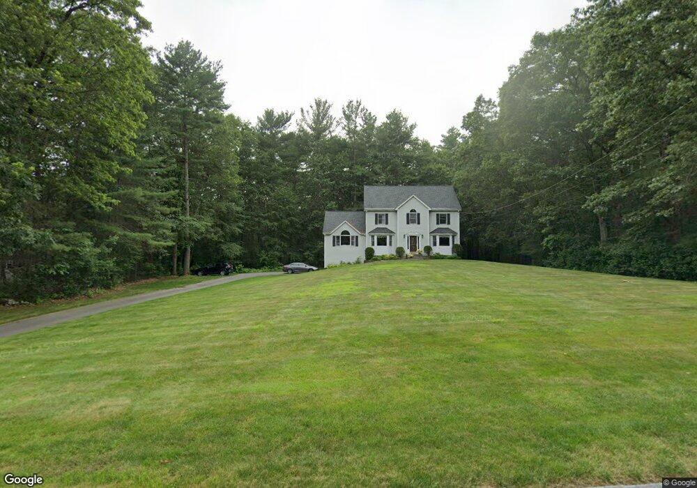
26 Appaloosa Cir Tyngsboro, MA 01879
Estimated Value: $851,794 - $967,000
4
Beds
3
Baths
2,647
Sq Ft
$337/Sq Ft
Est. Value
About This Home
This home is located at 26 Appaloosa Cir, Tyngsboro, MA 01879 and is currently estimated at $890,949, approximately $336 per square foot. 26 Appaloosa Cir is a home located in Middlesex County with nearby schools including Tyngsborough Elementary School, Tyngsborough Middle School, and Tyngsborough High School.
Ownership History
Date
Name
Owned For
Owner Type
Purchase Details
Closed on
Dec 8, 2004
Sold by
Afra Rt and Ali Iqbal
Bought by
Metropwest Bldrs Inc
Current Estimated Value
Purchase Details
Closed on
Aug 31, 1995
Sold by
Am Dev Corp
Bought by
Silva Anthony J and Silva Almerinda
Home Financials for this Owner
Home Financials are based on the most recent Mortgage that was taken out on this home.
Original Mortgage
$140,000
Interest Rate
7.71%
Create a Home Valuation Report for This Property
The Home Valuation Report is an in-depth analysis detailing your home's value as well as a comparison with similar homes in the area
Home Values in the Area
Average Home Value in this Area
Purchase History
| Date | Buyer | Sale Price | Title Company |
|---|---|---|---|
| Metropwest Bldrs Inc | -- | -- | |
| Silva Anthony J | $255,900 | -- |
Source: Public Records
Mortgage History
| Date | Status | Borrower | Loan Amount |
|---|---|---|---|
| Previous Owner | Silva Anthony J | $140,000 | |
| Previous Owner | Silva Anthony J | $200,000 |
Source: Public Records
Tax History Compared to Growth
Tax History
| Year | Tax Paid | Tax Assessment Tax Assessment Total Assessment is a certain percentage of the fair market value that is determined by local assessors to be the total taxable value of land and additions on the property. | Land | Improvement |
|---|---|---|---|---|
| 2025 | $86 | $697,000 | $269,600 | $427,400 |
| 2024 | $8,637 | $679,000 | $262,900 | $416,100 |
| 2023 | $8,177 | $578,300 | $219,300 | $359,000 |
| 2022 | $7,845 | $525,100 | $191,000 | $334,100 |
| 2021 | $7,678 | $477,800 | $173,600 | $304,200 |
| 2020 | $7,569 | $465,800 | $164,900 | $300,900 |
| 2019 | $7,261 | $428,900 | $156,200 | $272,700 |
| 2018 | $7,164 | $418,700 | $156,200 | $262,500 |
| 2017 | $6,922 | $403,400 | $156,200 | $247,200 |
| 2016 | $6,764 | $385,200 | $156,200 | $229,000 |
| 2015 | $6,458 | $380,800 | $151,800 | $229,000 |
Source: Public Records
Map
Nearby Homes
- 45 Red Gate Rd
- 19 Sandstone Rd
- 15 Stone Ridge Rd
- 31 Sandstone Rd
- 250 Lowell St
- 7 Axletree Rd
- 20 Highland Rd
- 0 Lowell St
- 22 Highland Rd
- 295 Forest St
- 80 Tenney Rd
- 0 Dunstable Rd
- 109 Pond St
- 6 Caldwell Dr
- 28 Whispering Pines Rd
- 6 Ingalls Rd
- 26 N Hill Rd
- 9 Whispering Pines Rd Unit 9
- 18 Ingalls Rd
- 18 Big Rock Trail Unit 115
- 22 Appaloosa Cir
- 30 Appaloosa Cir
- 25 Appaloosa Cir
- 29 Appaloosa Cir
- 34 Appaloosa Cir
- 18 Appaloosa Cir
- 21 Appaloosa Cir
- 35 Appaloosa Cir
- 47 Appaloosa Cir
- 17 Appaloosa Cir
- 38 Appaloosa Cir
- 14 Appaloosa Cir
- 43 Appaloosa Cir
- 11 Appaloosa Cir
- 51 Appaloosa Cir
- 55 Appaloosa Cir
- 42 Appaloosa Cir
- 59 Appaloosa Cir
- 46 Appaloosa Cir
- 10 Appaloosa Cir