Estimated Value: $588,000 - $816,000
1
Bed
1
Bath
625
Sq Ft
$1,154/Sq Ft
Est. Value
About This Home
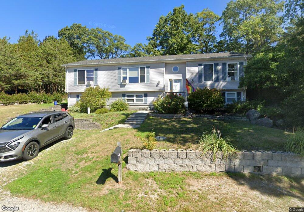
This home is located at 26 Barnstable Rd, Hull, MA 02045 and is currently estimated at $720,999, approximately $1,153 per square foot. 26 Barnstable Rd is a home located in Plymouth County with nearby schools including Lillian M. Jacobs Elementary School, Memorial Middle School, and Hull High School.
Ownership History
Date
Name
Owned For
Owner Type
Purchase Details
Closed on
Feb 13, 2020
Sold by
Torraco Kathleen M
Bought by
Creech Torraco Irt and Creech
Current Estimated Value
Purchase Details
Closed on
May 30, 2000
Sold by
Bulger John N
Bought by
Creech Robert W
Purchase Details
Closed on
May 22, 1996
Sold by
20-6 Barnstable St Rt and Morath
Bought by
Bulger John N
Create a Home Valuation Report for This Property
The Home Valuation Report is an in-depth analysis detailing your home's value as well as a comparison with similar homes in the area
Purchase History
| Date | Buyer | Sale Price | Title Company |
|---|---|---|---|
| Creech Torraco Irt | -- | None Available | |
| Creech Robert W | $136,000 | -- | |
| Bulger John N | $47,900 | -- |
Source: Public Records
Mortgage History
| Date | Status | Borrower | Loan Amount |
|---|---|---|---|
| Previous Owner | Bulger John N | $156,000 | |
| Previous Owner | Bulger John N | $156,000 | |
| Previous Owner | Bulger John N | $25,000 |
Source: Public Records
Tax History
| Year | Tax Paid | Tax Assessment Tax Assessment Total Assessment is a certain percentage of the fair market value that is determined by local assessors to be the total taxable value of land and additions on the property. | Land | Improvement |
|---|---|---|---|---|
| 2025 | $7,205 | $643,300 | $319,000 | $324,300 |
| 2024 | $7,175 | $615,900 | $308,700 | $307,200 |
| 2023 | $7,034 | $578,000 | $288,100 | $289,900 |
| 2022 | $6,563 | $523,400 | $267,600 | $255,800 |
| 2021 | $5,809 | $458,100 | $236,700 | $221,400 |
| 2020 | $5,429 | $423,500 | $236,700 | $186,800 |
| 2019 | $5,311 | $407,000 | $226,400 | $180,600 |
| 2018 | $5,129 | $382,200 | $226,400 | $155,800 |
| 2017 | $5,107 | $372,200 | $226,400 | $145,800 |
| 2016 | $4,761 | $353,200 | $226,400 | $126,800 |
| 2015 | $4,422 | $317,200 | $190,400 | $126,800 |
| 2014 | $4,276 | $308,300 | $190,400 | $117,900 |
Source: Public Records
Map
Nearby Homes
- 155 George Washington Blvd Unit 210
- 23 Wyola Rd
- 22 Berkley Rd Unit B
- 10 Berkley Rd Unit A
- 121 Nantasket Ave Unit 503
- 137 Hampton Cir
- 15 Lincoln Ave
- 127 Hampton Cir
- 99 Nantasket Ave
- 10 Chestnut Place
- 120 Nantasket Ave Unit 207
- 120 Nantasket Ave Unit 204
- 120 Nantasket Ave Unit 304
- 120 Nantasket Ave Unit PH5
- 120 Nantasket Ave Unit 201
- 2 Cliff Rd
- 1 Longbeach Ave Unit 202
- 3 3rd St
- 62 Oceanside Dr
- 6 State Park Rd Unit 2
- 28 Barnstable Rd
- 24 Barnstable Rd
- 1 Rowley St
- 22 Barnstable Rd
- 7 Salisbury St
- 3 Rowley St
- 20 Ipswich St
- 25 Ipswich St
- 35 Barnstable Rd
- 5 Rowley St
- 0 Salisbury St
- 45 Salisbury St
- 36 Barnstable Rd
- 11 N Truro St
- 11 N Truro St Unit 1
- 1 N Truro St
- 35 N Truro St
- 175 George Washington Blvd
- 175 George Washington Blvd Unit 2
- 175 George Washington Blvd Unit 1
Your Personal Tour Guide
Ask me questions while you tour the home.