
26 Bradburn Rd Waterboro, ME 04087
Waterboro NeighborhoodEstimated payment $7,108/month
Highlights
- Deeded Waterfront Access Rights
- Docks
- 5.93 Acre Lot
- 230 Feet of Waterfront
- Barn
- Farm
About This Home
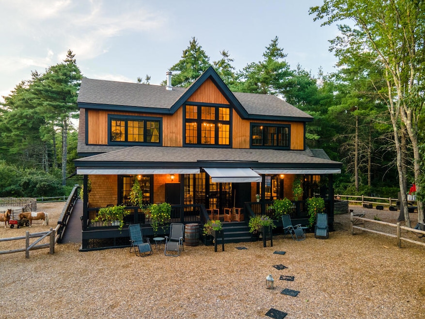
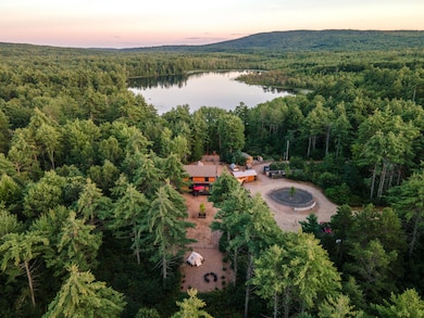
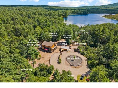
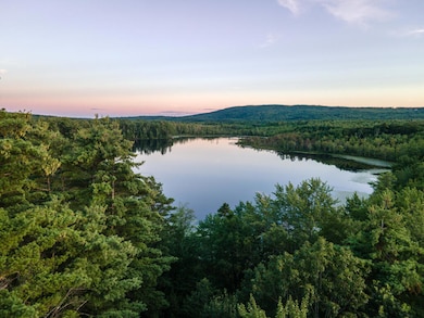
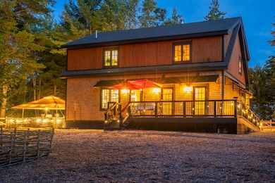
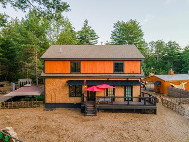
Welcome to The Shackteau—an enchanting French Country lakefront estate on the serene shores of Northwest Pond. With 230 feet of private frontage, this exceptional compound blends rustic European elegance with modern luxury. Designed as a peaceful family haven and formerly used as a boutique event venue, providing a perfect balance of nature, privacy, and refinement. The main residence radiates warmth and sophistication with an open floor plan centered around an elegant gas fireplace connecting the living, dining, and gourmet kitchen areas. Custom finishes, a well-appointed pantry, and a first-floor laundry room, enhance everyday living. Two full baths—one ADA compliant—each with exterior access, ideal for lakeside or garden activities. Upstairs, a kitchenette/wet bar serves three inviting bedrooms, including the primary suite with sweeping lake views. A double-sided gas fireplace connects the suite to its spa-inspired bath, creating a luxurious retreat. A cozy adjoining nursery or guest room adds versatility. The property evokes the charm of a French countryside compound, featuring a sauna, stylish tiny house for guests, a charming chicken coop, small barn, and several Amish-built outbuildings. The barn/carport had been home to two miniature horses and includes a feed room, freeze-proof auto-waterer, and exercise rink. Expansive awnings and thoughtfully designed outdoor spaces invite year-round enjoyment—from morning paddles to sunset fireside gatherings. Set on the peaceful, non-motorized Northwest Pond, ideal for swimming, paddling, and meditation—with kayak access to Lake Sherburne—The Shackteau is a sanctuary of serenity and timeless charm. Experience refined lakeside living—schedule your private tour of The Shackteau today. NOT A DRIVEBY. DO NOT GO ONTO PROPERTY WITHOUT A BROKER AND CONFIRMED APPOINTMENT.

Home Details
Home Type
- Single Family
Est. Annual Taxes
- $6,227
Year Built
- Built in 2022
Lot Details
- 5.93 Acre Lot
- 230 Feet of Waterfront
- Property fronts a private road
- Dirt Road
- Street terminates at a dead end
- Rural Setting
- Landscaped
- Level Lot
- Wooded Lot
- Property is zoned Shoreland
Property Views
- Water
- Scenic Vista
- Woods
Home Design
- Farmhouse Style Home
- Concrete Foundation
- Wood Frame Construction
- Shingle Roof
- Wood Siding
- Concrete Perimeter Foundation
Interior Spaces
- Multi-Level Property
- Built-In Features
- Cathedral Ceiling
- Ceiling Fan
- 2 Fireplaces
- Gas Fireplace
- Great Room
- Family Room
- Bonus Room
- Sink in Utility Room
- Storage Room
- Home Gym
- Tile Flooring
- Attic
Kitchen
- Eat-In Kitchen
- Gas Range
- Microwave
- Dishwasher
- Kitchen Island
- Granite Countertops
Bedrooms and Bathrooms
- 3 Bedrooms
- Primary bedroom located on second floor
- En-Suite Primary Bedroom
- Bedroom Suite
- 3 Full Bathrooms
- Soaking Tub and Shower Combination in Primary Bathroom
- Soaking Tub
Laundry
- Laundry Room
- Laundry on main level
- Dryer
- Washer
Finished Basement
- Basement Fills Entire Space Under The House
- Doghouse Basement Entry
- Exterior Basement Entry
Parking
- Carport
- Gravel Driveway
- Off-Street Parking
Accessible Home Design
- Roll-in Shower
- Bath Modification
- Accessible Approach with Ramp
Eco-Friendly Details
- ENERGY STAR/CFL/LED Lights
Outdoor Features
- Deeded Waterfront Access Rights
- Docks
- Shed
- Porch
Farming
- Barn
- Farm
- Agricultural
Utilities
- Cooling Available
- Zoned Heating
- Heating System Uses Gas
- Heat Pump System
- Radiant Heating System
- Baseboard Heating
- Hot Water Heating System
- Programmable Thermostat
- Generator Hookup
- Power Generator
- Private Water Source
- Well
- High-Efficiency Water Heater
- Septic Design Available
- Private Sewer
- Internet Available
Community Details
- No Home Owners Association
- Community Storage Space
Listing and Financial Details
- Tax Lot 06-001B
- Assessor Parcel Number WTBR-000009-000000-000006-000001B
Map
Home Values in the Area
Average Home Value in this Area
Tax History
| Year | Tax Paid | Tax Assessment Tax Assessment Total Assessment is a certain percentage of the fair market value that is determined by local assessors to be the total taxable value of land and additions on the property. | Land | Improvement |
|---|---|---|---|---|
| 2024 | $6,227 | $563,500 | $103,400 | $460,100 |
| 2023 | $5,857 | $443,700 | $106,600 | $337,100 |
| 2022 | $5,495 | $392,500 | $95,100 | $297,400 |
| 2021 | $1,377 | $91,500 | $86,400 | $5,100 |
| 2020 | $1,290 | $83,800 | $79,200 | $4,600 |
| 2019 | $1,108 | $72,000 | $72,000 | $0 |
| 2018 | $1,110 | $72,000 | $72,000 | $0 |
| 2017 | $1,112 | $72,000 | $72,000 | $0 |
| 2016 | $1,097 | $72,000 | $72,000 | $0 |
| 2015 | $1,108 | $79,400 | $79,400 | $0 |
| 2014 | $1,111 | $79,400 | $79,400 | $0 |
| 2013 | $1,083 | $79,400 | $79,400 | $0 |
Property History
| Date | Event | Price | List to Sale | Price per Sq Ft |
|---|---|---|---|---|
| 11/13/2025 11/13/25 | For Sale | $1,250,000 | -- | $458 / Sq Ft |
Purchase History
| Date | Type | Sale Price | Title Company |
|---|---|---|---|
| Quit Claim Deed | -- | None Available | |
| Warranty Deed | -- | -- |
Mortgage History
| Date | Status | Loan Amount | Loan Type |
|---|---|---|---|
| Open | $344,000 | Purchase Money Mortgage |
Source: Maine Listings
MLS Number: 1643234
APN: WTBR-000009-000000-000006-000001B
Disclaimer: Certain information contained herein is derived from information provided by parties other than Homes.com. All information provided is deemed reliable, but is not guaranteed to be accurate and should be independently verified.
![]() Listing data is derived in whole or in part from Maine Real Estate Information System, Inc. (d/b/a Maine Listings) and is for consumers' personal, noncommercial use only. Dimensions are approximate and not guaranteed. All data should be independently verified.
Listing data is derived in whole or in part from Maine Real Estate Information System, Inc. (d/b/a Maine Listings) and is for consumers' personal, noncommercial use only. Dimensions are approximate and not guaranteed. All data should be independently verified.
© 2025 Maine Real Estate Information System, Inc. All Rights Reserved. Equal Housing Opportunity.
Homes.com, LLC, 17600 Laguna Canyon Rd Irvine, CA 92618 (888)-952-6393
![]()
- 52 Long Causeway
- 205 Blueberry Rd
- 255 Ross Corner Rd
- Lot 14 Milk Rd
- 350 Pine Springs Rd
- 9 Restful Way
- Lot 35A Norton Ridge Rd
- 585 Newfield Rd
- 164 Granny Kent Pond Rd
- 152 Hanson Rd
- 92 Perch
- M13L30 Clarks Bridge Rd
- 282 Granny Kent Pond Rd
- 450 West Rd
- 002-031-B Shapleigh Corner Rd
- 3 Forest View Ln Unit 3
- 19 White Tail Ln
- 38-25.2 0 Row Mowry Ln
- 5 Clarks Bridge Rd
- 013-042C Sokokis Trail
- 71 Norton Ridge Rd
- 26 Hawthorne Rd Unit ID1255702P
- 60 Avery Rd
- 40 Main St Unit B
- 40 Main St Unit A
- 40 Main St Unit B
- 40 Main St
- 40 Main St
- 3 George St Unit B
- 24 Riverview St
- 6 Linden Ave
- 9 Gowen St
- 6 Mousam Ct
- 31 Shaw St Unit 31D Shaw St.
- 21 Roberts St Unit A
- 933 Main St
- 10 W Elm St Unit A
- 985 Main St Unit 985 Main
- 134 School St
- 435 High St