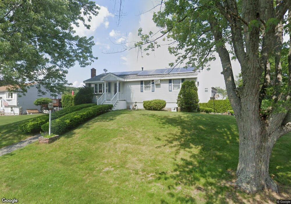
26 Chippy Ln Methuen, MA 01844
The East End NeighborhoodEstimated Value: $599,000 - $661,000
3
Beds
2
Baths
2,059
Sq Ft
$300/Sq Ft
Est. Value
About This Home
This home is located at 26 Chippy Ln, Methuen, MA 01844 and is currently estimated at $618,107, approximately $300 per square foot. 26 Chippy Ln is a home located in Essex County with nearby schools including South Point Elementary School, Methuen High School, and Saint Monica School.
Ownership History
Date
Name
Owned For
Owner Type
Purchase Details
Closed on
Jun 9, 2014
Sold by
Maalouf George J
Bought by
Maalouf George J and Maalouf Zeina
Current Estimated Value
Home Financials for this Owner
Home Financials are based on the most recent Mortgage that was taken out on this home.
Original Mortgage
$240,320
Outstanding Balance
$129,742
Interest Rate
4.33%
Mortgage Type
New Conventional
Estimated Equity
$488,366
Purchase Details
Closed on
May 19, 2000
Sold by
Gordon John R and Gordon Annette M
Bought by
Maalouf George J
Purchase Details
Closed on
Apr 11, 1988
Sold by
Harvey Steven R
Bought by
Gordon John R
Create a Home Valuation Report for This Property
The Home Valuation Report is an in-depth analysis detailing your home's value as well as a comparison with similar homes in the area
Home Values in the Area
Average Home Value in this Area
Purchase History
| Date | Buyer | Sale Price | Title Company |
|---|---|---|---|
| Maalouf George J | -- | -- | |
| Maalouf George J | -- | -- | |
| Maalouf George J | -- | -- | |
| Maalouf George J | $196,000 | -- | |
| Maalouf George J | $196,000 | -- | |
| Gordon John R | $162,000 | -- |
Source: Public Records
Mortgage History
| Date | Status | Borrower | Loan Amount |
|---|---|---|---|
| Open | Maalouf George J | $240,320 | |
| Closed | Gordon John R | $240,320 |
Source: Public Records
Tax History Compared to Growth
Tax History
| Year | Tax Paid | Tax Assessment Tax Assessment Total Assessment is a certain percentage of the fair market value that is determined by local assessors to be the total taxable value of land and additions on the property. | Land | Improvement |
|---|---|---|---|---|
| 2025 | $5,343 | $505,000 | $216,900 | $288,100 |
| 2024 | $5,374 | $494,800 | $197,200 | $297,600 |
| 2023 | $5,082 | $434,400 | $176,100 | $258,300 |
| 2022 | $4,779 | $366,200 | $140,900 | $225,300 |
| 2021 | $4,475 | $339,300 | $133,800 | $205,500 |
| 2020 | $4,458 | $331,700 | $133,800 | $197,900 |
| 2019 | $4,261 | $300,300 | $126,800 | $173,500 |
| 2018 | $4,153 | $291,000 | $126,800 | $164,200 |
| 2017 | $4,011 | $273,800 | $126,800 | $147,000 |
| 2016 | $3,939 | $266,000 | $126,800 | $139,200 |
| 2015 | $3,815 | $261,300 | $126,800 | $134,500 |
Source: Public Records
Map
Nearby Homes
- 122 Pleasant Valley St
- 128 Pleasant Valley St
- 86 Comet Rd
- 23 Constitution Way Unit 23
- 23 Constitution Way
- 95 Pilgrim Cir Unit 95
- 45 Washington St Unit 55
- 3 Woekel Terrace
- 43 Duston Dr
- 37 Albion St
- 5 Harmony Ln
- 15 Junior Ave
- Lot 2 Washington St
- 4 Alderbrook Ln
- 2 Goodrich Ave
- 63 Lippold St
- 29 Wallace St
- 687 Jackson St
- 27 Russell Farm Dr
- 49 Golf Ave