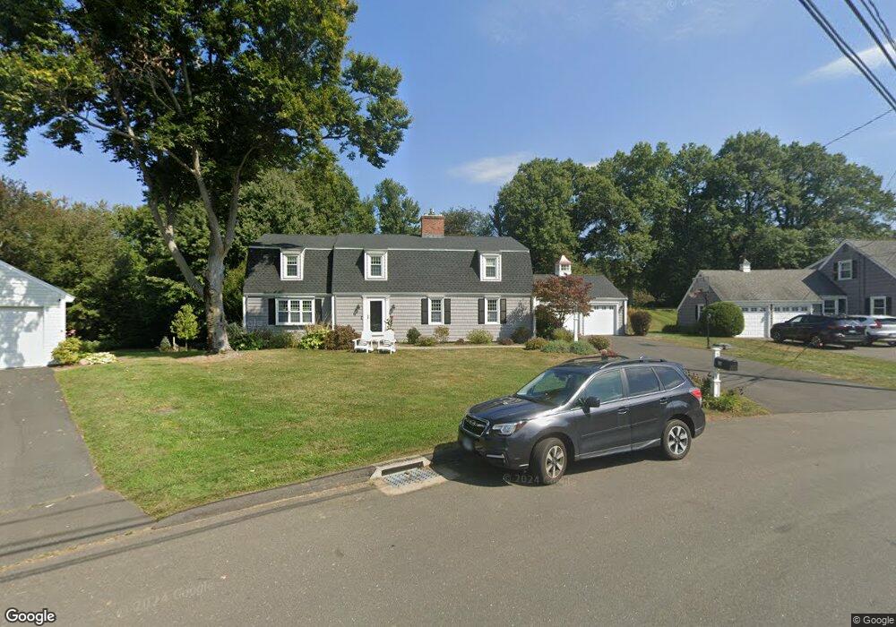
26 Claybar Dr West Hartford, CT 06117
Estimated Value: $997,000 - $1,121,000
5
Beds
4
Baths
3,477
Sq Ft
$303/Sq Ft
Est. Value
About This Home
This home is located at 26 Claybar Dr, West Hartford, CT 06117 and is currently estimated at $1,051,901, approximately $302 per square foot. 26 Claybar Dr is a home located in Hartford County with nearby schools including Bugbee School, King Philip Middle School, and Hall High School.
Ownership History
Date
Name
Owned For
Owner Type
Purchase Details
Closed on
Dec 11, 2020
Sold by
Miller Wendy A
Bought by
Miller Wendy A and Miller Thomas B
Current Estimated Value
Purchase Details
Closed on
Sep 16, 2010
Sold by
Miller Thomas B
Bought by
Miller Wendy A
Purchase Details
Closed on
Sep 21, 2009
Sold by
Miller Thomas B
Bought by
Miller Wendy A
Purchase Details
Closed on
May 2, 2005
Sold by
Offsay Janet E
Bought by
Miller Thomas B and Miller Wendy A
Create a Home Valuation Report for This Property
The Home Valuation Report is an in-depth analysis detailing your home's value as well as a comparison with similar homes in the area
Home Values in the Area
Average Home Value in this Area
Purchase History
| Date | Buyer | Sale Price | Title Company |
|---|---|---|---|
| Miller Wendy A | -- | None Available | |
| Miller Wendy A | -- | -- | |
| Miller Thomas B | -- | -- | |
| Miller Wendy A | -- | -- | |
| Miller Thomas B | $550,000 | -- |
Source: Public Records
Mortgage History
| Date | Status | Borrower | Loan Amount |
|---|---|---|---|
| Previous Owner | Miller Thomas B | $400,000 | |
| Previous Owner | Miller Thomas B | $417,000 | |
| Previous Owner | Miller Thomas B | $50,000 |
Source: Public Records
Tax History Compared to Growth
Tax History
| Year | Tax Paid | Tax Assessment Tax Assessment Total Assessment is a certain percentage of the fair market value that is determined by local assessors to be the total taxable value of land and additions on the property. | Land | Improvement |
|---|---|---|---|---|
| 2025 | $21,772 | $486,190 | $146,900 | $339,290 |
| 2024 | $20,590 | $486,190 | $146,900 | $339,290 |
| 2023 | $19,895 | $486,190 | $146,900 | $339,290 |
| 2022 | $19,778 | $486,190 | $146,900 | $339,290 |
| 2021 | $17,891 | $421,750 | $146,900 | $274,850 |
| 2020 | $17,629 | $421,750 | $137,400 | $284,350 |
| 2019 | $17,629 | $421,750 | $137,410 | $284,340 |
| 2018 | $17,292 | $421,750 | $137,410 | $284,340 |
| 2017 | $17,162 | $418,180 | $133,840 | $284,340 |
| 2016 | $13,945 | $352,940 | $96,040 | $256,900 |
| 2015 | $13,521 | $352,940 | $96,040 | $256,900 |
| 2014 | $12,823 | $343,140 | $96,040 | $247,100 |
Source: Public Records
Map
Nearby Homes
- 37 W Normandy Dr
- 123 Westmont St
- 6 W Maxwell Dr
- 14 Cedar Ledge Rd
- 55 E Maxwell Dr
- 124 High Ridge Rd
- 64 Harvest Ln
- 592 Mountain Rd Unit A
- 39 Wyndwood Rd
- 162 Balfour Dr
- 15 Rushleigh Rd
- 2645 Albany Ave
- 21 Rushleigh Rd
- 6 Old Oak Rd
- 62 Blue Ridge Ln
- 2581 Albany Ave
- 140 Hunter Dr
- 269 Mountain Rd
- 14 Gledhill Ln
- 37 Balfour Dr