
Seller's Agent in 2025
Paul Reardon
William Raveis R.E. & Home Services
(781) 395-7676
1 in this area
79 Total Sales
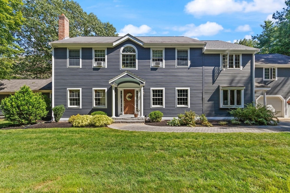


Highly desirable East Boxford beautiful 4-bed 3.5-bath Colonial with a 3 garage spaces in the Historic District surrounded by nature on a level lot with an expansive 1.6-acre yard. Majestic bright two-story entry foyer. First floor formal dining room. Open living/kitchen area the heart of this home loaded with natural light. Enormous windows. Half bath. Laundry. Direct access to 2-car garage. Heated year-round enclosed porch w/gas fireplace. Relax, entertain and watch nature on the beautiful deck/patio. Second floor Primary Suite w/walk in closet, renovated bath w/soaking tub. Two additional bedrooms, a home office with French doors. Full bath and an amazing bonus gathering area with fireplace, pool table (a gift from the seller) and bar area. First floor In-law suite w/fireplaced living area, kitchen, den, bedroom with a 3/4 bath. Direct access to private farmers porch overlooking the yard. Short distance to route 95,the Town Center, Senior Center, schools, Boxford Community Kitchen.
Last Agent to Sell the Property
William Raveis R.E. & Home Services Listed on: 09/03/2025
| Date | Type | Sale Price | Title Company |
|---|---|---|---|
| Quit Claim Deed | $1,175,000 | -- | |
| Deed | $731,250 | -- |
| Date | Status | Loan Amount | Loan Type |
|---|---|---|---|
| Open | $500,000 | Purchase Money Mortgage | |
| Previous Owner | $410,000 | No Value Available | |
| Previous Owner | $417,000 | No Value Available | |
| Previous Owner | $417,000 | Purchase Money Mortgage | |
| Previous Owner | $203,000 | No Value Available |
| Date | Event | Price | List to Sale | Price per Sq Ft |
|---|---|---|---|---|
| 11/20/2025 11/20/25 | Sold | $1,175,000 | -9.5% | $291 / Sq Ft |
| 09/26/2025 09/26/25 | Pending | -- | -- | -- |
| 09/03/2025 09/03/25 | For Sale | $1,299,000 | -- | $322 / Sq Ft |
| Year | Tax Paid | Tax Assessment Tax Assessment Total Assessment is a certain percentage of the fair market value that is determined by local assessors to be the total taxable value of land and additions on the property. | Land | Improvement |
|---|---|---|---|---|
| 2025 | $15,052 | $1,119,100 | $369,000 | $750,100 |
| 2024 | $14,604 | $1,119,100 | $369,000 | $750,100 |
| 2023 | $12,993 | $938,800 | $329,400 | $609,400 |
| 2022 | $12,663 | $832,000 | $274,400 | $557,600 |
| 2021 | $12,107 | $756,200 | $249,400 | $506,800 |
| 2020 | $12,507 | $773,500 | $249,400 | $524,100 |
| 2019 | $12,050 | $740,200 | $237,700 | $502,500 |
| 2018 | $11,868 | $732,600 | $237,700 | $494,900 |
| 2017 | $12,113 | $742,700 | $226,700 | $516,000 |
| 2016 | $12,332 | $749,200 | $226,700 | $522,500 |
| 2015 | $11,676 | $730,200 | $226,700 | $503,500 |
Seller's Agent in 2025
Paul Reardon
William Raveis R.E. & Home Services
(781) 395-7676
1 in this area
79 Total Sales
Seller Co-Listing Agent in 2025
Mary Lewis
William Raveis R.E. & Home Services
(617) 429-3818
1 in this area
9 Total Sales
Buyer's Agent in 2025
Candice Hodgson
Lyv Realty
(978) 979-9964
2 in this area
176 Total Sales
Source: MLS Property Information Network (MLS PIN)
MLS Number: 73423747
APN: BOXF-000033-000001-000022
Disclaimer: Certain information contained herein is derived from information provided by parties other than Homes.com. All information provided is deemed reliable, but is not guaranteed to be accurate and should be independently verified.
![]() The property listing data and information, or the Images, set forth herein were provided to MLS Property Information Network, Inc. from third party sources, including sellers, lessors and public records, and were compiled by MLS Property Information Network, Inc. The property listing data and information, and the Images, are for the personal, non-commercial use of consumers having a good faith interest in purchasing or leasing listed properties of the type displayed to them and may not be used for any purpose other than to identify prospective properties which such consumers may have a good faith interest in purchasing or leasing. MLS Property Information Network, Inc. and its subscribers disclaim any and all representations and warranties as to the accuracy of the property listing data and information, or as to the accuracy of any of the Images, set forth herein.
The property listing data and information, or the Images, set forth herein were provided to MLS Property Information Network, Inc. from third party sources, including sellers, lessors and public records, and were compiled by MLS Property Information Network, Inc. The property listing data and information, and the Images, are for the personal, non-commercial use of consumers having a good faith interest in purchasing or leasing listed properties of the type displayed to them and may not be used for any purpose other than to identify prospective properties which such consumers may have a good faith interest in purchasing or leasing. MLS Property Information Network, Inc. and its subscribers disclaim any and all representations and warranties as to the accuracy of the property listing data and information, or as to the accuracy of any of the Images, set forth herein.
Ask me questions while you tour the home.