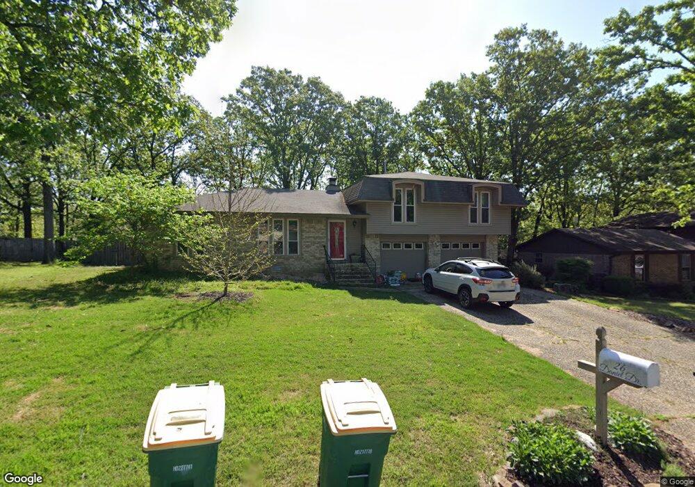
26 Daniel Dr Sherwood, AR 72120
Estimated Value: $200,952 - $261,000
--
Bed
2
Baths
1,780
Sq Ft
$131/Sq Ft
Est. Value
About This Home
This home is located at 26 Daniel Dr, Sherwood, AR 72120 and is currently estimated at $233,238, approximately $131 per square foot. 26 Daniel Dr is a home located in Pulaski County with nearby schools including Sherwood Elementary School, Sylvan Hills Middle School, and Sylvan Hills High School.
Ownership History
Date
Name
Owned For
Owner Type
Purchase Details
Closed on
Apr 19, 2001
Sold by
Price Jesse C and Price Elyse
Bought by
Williams James J and Williams Lori K
Current Estimated Value
Home Financials for this Owner
Home Financials are based on the most recent Mortgage that was taken out on this home.
Original Mortgage
$112,950
Interest Rate
6.89%
Mortgage Type
FHA
Purchase Details
Closed on
May 27, 1999
Sold by
Price Jesse
Bought by
Price Elyse
Purchase Details
Closed on
Jun 19, 1998
Sold by
Mcmahan Jack W and Mcmahan Flora C
Bought by
Price Jesse C
Home Financials for this Owner
Home Financials are based on the most recent Mortgage that was taken out on this home.
Original Mortgage
$106,600
Interest Rate
7.21%
Mortgage Type
VA
Create a Home Valuation Report for This Property
The Home Valuation Report is an in-depth analysis detailing your home's value as well as a comparison with similar homes in the area
Home Values in the Area
Average Home Value in this Area
Purchase History
| Date | Buyer | Sale Price | Title Company |
|---|---|---|---|
| Williams James J | $114,000 | Lenders Title Company | |
| Price Elyse | -- | -- | |
| Price Jesse C | $104,000 | American Abstract & Title Co |
Source: Public Records
Mortgage History
| Date | Status | Borrower | Loan Amount |
|---|---|---|---|
| Closed | Williams James J | $112,950 | |
| Previous Owner | Price Jesse C | $106,600 |
Source: Public Records
Tax History Compared to Growth
Tax History
| Year | Tax Paid | Tax Assessment Tax Assessment Total Assessment is a certain percentage of the fair market value that is determined by local assessors to be the total taxable value of land and additions on the property. | Land | Improvement |
|---|---|---|---|---|
| 2025 | $1,634 | $35,276 | $6,600 | $28,676 |
| 2024 | $1,498 | $35,276 | $6,600 | $28,676 |
| 2023 | $1,498 | $35,276 | $6,600 | $28,676 |
| 2022 | $1,609 | $35,276 | $6,600 | $28,676 |
| 2021 | $1,486 | $26,130 | $6,000 | $20,130 |
| 2020 | $1,105 | $26,130 | $6,000 | $20,130 |
| 2019 | $1,105 | $26,130 | $6,000 | $20,130 |
| 2018 | $1,130 | $26,130 | $6,000 | $20,130 |
| 2017 | $1,121 | $26,130 | $6,000 | $20,130 |
| 2016 | $1,381 | $26,500 | $6,600 | $19,900 |
| 2015 | $1,346 | $26,500 | $6,600 | $19,900 |
| 2014 | $1,346 | $26,500 | $6,600 | $19,900 |
Source: Public Records
Map
Nearby Homes
- 11 Daniel Dr
- +/- 8.16 Acres Windchime Ave
- 1301 Stafford Rd
- 1300 Stafford Rd
- 4636 Brandywine Cove
- 1800 Palomino Dr
- 619 Newcastle Dr
- 609 Newcastle Dr
- 8000 Pinto Trail
- 626 Newcastle Dr
- 618 & 620 Newcastle Dr
- 610 Newcastle Dr
- 622 Newcastle Dr
- 1415 Stafford Rd
- 615 & 617 Brierly Dr
- 615 Brierly Dr
- 1419 Stafford Rd
- 1423 Stafford Rd
- 1501 Stafford Rd
- +/- 21.56 Acres Stafford Rd
- 24 Daniel Dr
- 28 Daniel Dr
- 327 Alanbrook Ave
- 329 Alanbrook Ave
- 25 Daniel Dr
- 22 Daniel Dr
- 325 Alanbrook Ave
- 331 Alanbrook Ave
- 30 Daniel Dr
- 21 Daniel Dr
- 323 Alanbrook Ave
- 29 Daniel Dr
- 333 Alanbrook Ave
- 20 Daniel Dr
- 19 Daniel Dr
- 321 Alanbrook Ave
- 335 Alanbrook Ave
- 328 Alanbrook Ave
- 326 Alanbrook Ave
- 33 Daniel Dr