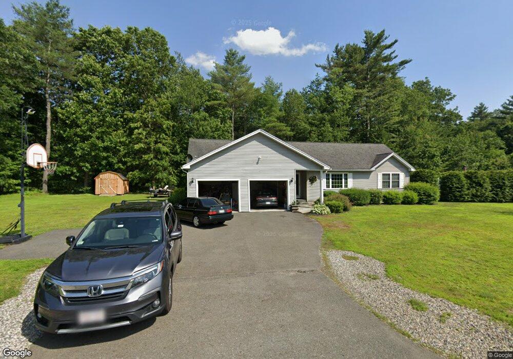
26 E Wayland Dr Greenfield, MA 01301
Estimated Value: $442,000 - $639,000
3
Beds
3
Baths
1,580
Sq Ft
$321/Sq Ft
Est. Value
About This Home
This home is located at 26 E Wayland Dr, Greenfield, MA 01301 and is currently estimated at $507,380, approximately $321 per square foot. 26 E Wayland Dr is a home with nearby schools including Greenfield Center School, Cornerstone Christian School, and Four Winds School.
Ownership History
Date
Name
Owned For
Owner Type
Purchase Details
Closed on
Nov 30, 2010
Sold by
Cersosimo Ind Inc
Bought by
Adams Tony A and Adams Amy C
Current Estimated Value
Home Financials for this Owner
Home Financials are based on the most recent Mortgage that was taken out on this home.
Original Mortgage
$263,150
Outstanding Balance
$169,328
Interest Rate
4.25%
Mortgage Type
FHA
Estimated Equity
$338,052
Create a Home Valuation Report for This Property
The Home Valuation Report is an in-depth analysis detailing your home's value as well as a comparison with similar homes in the area
Home Values in the Area
Average Home Value in this Area
Purchase History
| Date | Buyer | Sale Price | Title Company |
|---|---|---|---|
| Adams Tony A | $270,000 | -- | |
| Adams Tony A | $270,000 | -- |
Source: Public Records
Mortgage History
| Date | Status | Borrower | Loan Amount |
|---|---|---|---|
| Open | Adams Tony A | $263,150 | |
| Closed | Adams Tony A | $263,150 |
Source: Public Records
Tax History
| Year | Tax Paid | Tax Assessment Tax Assessment Total Assessment is a certain percentage of the fair market value that is determined by local assessors to be the total taxable value of land and additions on the property. | Land | Improvement |
|---|---|---|---|---|
| 2025 | $8,753 | $447,500 | $97,100 | $350,400 |
| 2024 | $8,965 | $439,700 | $88,300 | $351,400 |
| 2023 | $8,084 | $411,400 | $88,300 | $323,100 |
| 2022 | $7,540 | $337,800 | $80,100 | $257,700 |
| 2021 | $7,349 | $316,500 | $83,700 | $232,800 |
| 2020 | $6,817 | $297,300 | $83,700 | $213,600 |
| 2019 | $6,431 | $287,600 | $72,900 | $214,700 |
| 2018 | $6,370 | $284,000 | $71,300 | $212,700 |
| 2017 | $6,171 | $284,000 | $71,300 | $212,700 |
| 2016 | $5,961 | $273,300 | $68,100 | $205,200 |
| 2015 | $6,105 | $271,200 | $68,100 | $203,100 |
| 2014 | $5,562 | $270,900 | $68,100 | $202,800 |
Source: Public Records
Map
Nearby Homes
- 001 Adams Rd
- 47 Cross St
- 85 Verde Dr
- 111 South St
- 75 South St Unit 3
- 18 Lillian St
- 23 Industrial Dr
- 182 Main Rd
- 25 Barton Rd
- 1 Northfield Rd
- 0 Fox Hill Rd Unit 73477185
- 402 Country Side Rd
- 20 Dunnell Rd
- 132 Poplar St
- 77 Summer St
- 10 Worcester Ave
- 539 Fox Hill Rd
- 0 Millers Falls Rd Unit 73034825
- 372 Federal St
- 18 E Cleveland St
- 7 Wayland Dr
- 5 Wayland Dr
- 3 Wayland Dr
- 32 E Wayland Dr
- 21 E Wayland Dr
- 14 E Wayland Dr
- 342 Log Plain Rd
- 6 Wayland Dr
- 4 Wayland Dr
- 39 E Wayland Dr
- 344 Log Plain Rd
- 316 Log Plain Rd
- 330 Log Plain Rd
- 38 E Wayland Dr
- 41 E Wayland Dr
- 336 Log Plain Rd
- 329 Log Plain Rd
- 325 Log Plain Rd
- 319 Log Plain Rd
- 333 Log Plain Rd
Your Personal Tour Guide
Ask me questions while you tour the home.