Estimated Value: $648,306 - $679,000
3
Beds
2
Baths
1,080
Sq Ft
$617/Sq Ft
Est. Value
About This Home
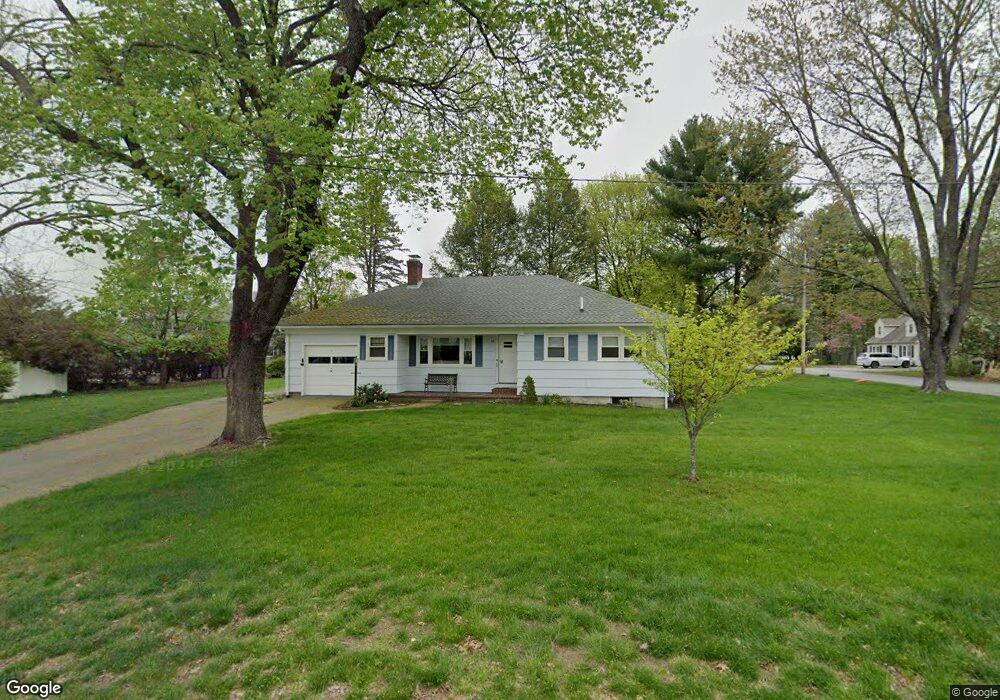
This home is located at 26 Elm St, Acton, MA 01720 and is currently estimated at $666,577, approximately $617 per square foot. 26 Elm St is a home located in Middlesex County with nearby schools including Acton-Boxborough Regional High School.
Ownership History
Date
Name
Owned For
Owner Type
Purchase Details
Closed on
Oct 15, 1998
Sold by
Stramaglia Eileen C and Stramaglia Steven M
Bought by
Werst Leonard and Werst Dorothy
Current Estimated Value
Purchase Details
Closed on
Jan 23, 1997
Sold by
Elm St Rt and Efstratoudakis
Bought by
Stramaglia Eileen C and Stramaglia Steven M
Home Financials for this Owner
Home Financials are based on the most recent Mortgage that was taken out on this home.
Original Mortgage
$173,600
Interest Rate
7.5%
Mortgage Type
Purchase Money Mortgage
Purchase Details
Closed on
Aug 20, 1996
Sold by
Hanasik Joseph R Est and Gregoritch
Bought by
Elm Street Rt and Efstratoudakis
Home Financials for this Owner
Home Financials are based on the most recent Mortgage that was taken out on this home.
Original Mortgage
$269,925
Interest Rate
8.08%
Mortgage Type
Purchase Money Mortgage
Create a Home Valuation Report for This Property
The Home Valuation Report is an in-depth analysis detailing your home's value as well as a comparison with similar homes in the area
Home Values in the Area
Average Home Value in this Area
Purchase History
| Date | Buyer | Sale Price | Title Company |
|---|---|---|---|
| Werst Leonard | $232,000 | -- | |
| Stramaglia Eileen C | $217,000 | -- | |
| Elm Street Rt | $255,000 | -- |
Source: Public Records
Mortgage History
| Date | Status | Borrower | Loan Amount |
|---|---|---|---|
| Previous Owner | Elm Street Rt | $173,000 | |
| Previous Owner | Elm Street Rt | $173,600 | |
| Previous Owner | Elm Street Rt | $269,925 |
Source: Public Records
Tax History Compared to Growth
Tax History
| Year | Tax Paid | Tax Assessment Tax Assessment Total Assessment is a certain percentage of the fair market value that is determined by local assessors to be the total taxable value of land and additions on the property. | Land | Improvement |
|---|---|---|---|---|
| 2025 | $9,251 | $539,400 | $273,800 | $265,600 |
| 2024 | $8,788 | $527,200 | $273,800 | $253,400 |
| 2023 | $8,520 | $485,200 | $249,000 | $236,200 |
| 2022 | $8,474 | $435,700 | $216,300 | $219,400 |
| 2021 | $8,096 | $400,200 | $200,400 | $199,800 |
| 2020 | $7,592 | $394,600 | $200,400 | $194,200 |
| 2019 | $7,062 | $364,600 | $200,400 | $164,200 |
| 2018 | $6,607 | $340,900 | $200,400 | $140,500 |
| 2017 | $6,581 | $345,300 | $200,400 | $144,900 |
| 2016 | $6,223 | $323,600 | $200,400 | $123,200 |
| 2015 | $6,191 | $325,000 | $200,400 | $124,600 |
| 2014 | $6,216 | $319,600 | $200,400 | $119,200 |
Source: Public Records
Map
Nearby Homes
- 9 Elm St Unit 1
- 5 Elm St Unit 1
- 285 Central St Unit 285
- 31 Mohawk Dr
- 89 Windsor Ave
- 4 Huron Rd
- 68 Macintosh Ln
- 4,7,8 Crestwood Ln
- 92 Willow St Unit 3
- 92 Willow St Unit 2
- 90 Willow St Unit 1
- 134 Russet Ln
- 169 Main St
- 12 Olde Lantern Rd
- 3 Heather Hill Rd
- 19 Railroad St Unit C2
- 129 Main St Unit 129
- 129 Main St
- 131 Main St
- 23 John Swift Rd