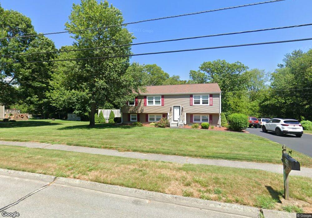
26 Paula Dr Swansea, MA 02777
Luther Corner NeighborhoodEstimated Value: $446,000 - $552,000
3
Beds
2
Baths
1,170
Sq Ft
$437/Sq Ft
Est. Value
About This Home
This home is located at 26 Paula Dr, Swansea, MA 02777 and is currently estimated at $511,138, approximately $436 per square foot. 26 Paula Dr is a home located in Bristol County with nearby schools including Joseph Case High School, Highlander Charter Middle and High School, and East Bay Career Academy.
Ownership History
Date
Name
Owned For
Owner Type
Purchase Details
Closed on
Jan 24, 1992
Sold by
Fall River Sb
Bought by
Duphily Rene A and Duphily Pauline
Current Estimated Value
Purchase Details
Closed on
Jan 16, 1992
Sold by
Alfonso Patricia
Bought by
Fr Five Cents Sb
Purchase Details
Closed on
May 24, 1990
Sold by
Emond Norman
Bought by
Canuel Rita
Create a Home Valuation Report for This Property
The Home Valuation Report is an in-depth analysis detailing your home's value as well as a comparison with similar homes in the area
Home Values in the Area
Average Home Value in this Area
Purchase History
| Date | Buyer | Sale Price | Title Company |
|---|---|---|---|
| Duphily Rene A | $110,000 | -- | |
| Fr Five Cents Sb | $35,000 | -- | |
| Canuel Rita | $89,500 | -- |
Source: Public Records
Mortgage History
| Date | Status | Borrower | Loan Amount |
|---|---|---|---|
| Open | Canuel Rita | $170,000 | |
| Closed | Canuel Rita | $40,000 |
Source: Public Records
Tax History Compared to Growth
Tax History
| Year | Tax Paid | Tax Assessment Tax Assessment Total Assessment is a certain percentage of the fair market value that is determined by local assessors to be the total taxable value of land and additions on the property. | Land | Improvement |
|---|---|---|---|---|
| 2025 | $5,161 | $433,000 | $207,000 | $226,000 |
| 2024 | $5,204 | $434,000 | $202,000 | $232,000 |
| 2023 | $4,924 | $375,000 | $148,200 | $226,800 |
| 2022 | $4,710 | $327,300 | $134,700 | $192,600 |
| 2021 | $4,719 | $301,900 | $138,300 | $163,600 |
| 2020 | $4,880 | $313,200 | $142,900 | $170,300 |
| 2019 | $4,563 | $294,200 | $125,500 | $168,700 |
| 2018 | $4,289 | $280,700 | $118,300 | $162,400 |
| 2017 | $3,737 | $281,400 | $128,600 | $152,800 |
| 2016 | $4,001 | $295,900 | $136,200 | $159,700 |
| 2015 | $3,766 | $286,800 | $136,200 | $150,600 |
| 2014 | $3,473 | $270,500 | $136,200 | $134,300 |
Source: Public Records
Map
Nearby Homes
- 46 Magnolia Dr
- 1261 Gar Hwy
- 447 Old Warren Rd
- 79 Cedar Ave
- 34 Columbia Rd
- 147 Bushee Rd
- 105 Birchwood Dr
- 25 Inverness Rd
- 4 Meadowbrook Ave
- 9 Kenny Dr
- 20 Sherbourne Ave
- 153 Puffer Ave
- Lot 11 Lynch
- 0 Proprietors Way Unit 73324662
- Lot 10 Lynch
- 41 James Ave
- 192 Schoolhouse Rd
- 17 Colonial Dr
- 196 Coolidge St
- 502 Ocean Grove Ave