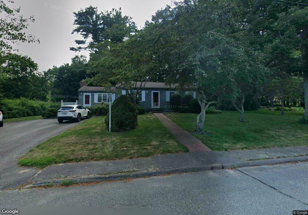
26 Prince Cir Marshfield, MA 02050
Estimated Value: $636,000 - $827,000
4
Beds
2
Baths
1,238
Sq Ft
$574/Sq Ft
Est. Value
About This Home
This home is located at 26 Prince Cir, Marshfield, MA 02050 and is currently estimated at $710,755, approximately $574 per square foot. 26 Prince Cir is a home located in Plymouth County with nearby schools including Governor Edward Winslow School, Furnace Brook Middle School, and Marshfield High School.
Ownership History
Date
Name
Owned For
Owner Type
Purchase Details
Closed on
Mar 18, 2024
Sold by
Nee Paul V and Nee Kathleen M
Bought by
Nee Ft and Nee
Current Estimated Value
Purchase Details
Closed on
Aug 24, 1992
Sold by
Kramer Larry S and Kramer Nicole J
Bought by
Nee Ii Paul and Nee Kathleen M
Create a Home Valuation Report for This Property
The Home Valuation Report is an in-depth analysis detailing your home's value as well as a comparison with similar homes in the area
Home Values in the Area
Average Home Value in this Area
Purchase History
| Date | Buyer | Sale Price | Title Company |
|---|---|---|---|
| Nee Ft | -- | None Available | |
| Nee Ft | -- | None Available | |
| Nee Ii Paul | $134,500 | -- | |
| Nee Paul V | $134,500 | -- |
Source: Public Records
Mortgage History
| Date | Status | Borrower | Loan Amount |
|---|---|---|---|
| Previous Owner | Nee Paul V | $136,000 | |
| Previous Owner | Nee Paul V | $150,000 | |
| Previous Owner | Nee Paul V | $142,000 |
Source: Public Records
Tax History Compared to Growth
Tax History
| Year | Tax Paid | Tax Assessment Tax Assessment Total Assessment is a certain percentage of the fair market value that is determined by local assessors to be the total taxable value of land and additions on the property. | Land | Improvement |
|---|---|---|---|---|
| 2025 | $5,604 | $566,100 | $305,300 | $260,800 |
| 2024 | $5,468 | $526,300 | $290,700 | $235,600 |
| 2023 | $5,394 | $476,500 | $259,600 | $216,900 |
| 2022 | $5,180 | $400,000 | $218,100 | $181,900 |
| 2021 | $5,078 | $385,000 | $218,100 | $166,900 |
| 2020 | $4,811 | $360,900 | $197,300 | $163,600 |
| 2019 | $4,529 | $338,500 | $197,300 | $141,200 |
| 2018 | $4,462 | $333,700 | $197,300 | $136,400 |
| 2017 | $4,491 | $327,300 | $197,300 | $130,000 |
| 2016 | $4,364 | $314,400 | $197,300 | $117,100 |
| 2015 | $4,049 | $304,700 | $197,300 | $107,400 |
| 2014 | $3,996 | $300,700 | $197,300 | $103,400 |
Source: Public Records
Map
Nearby Homes
- 112 Partridge Brook Cir
- 74 Abrams Hill Rd
- 25 Hawthorn Hill
- 9 S Pasture Ln
- 10 Hawthorn Hill
- Two Railroad Ave Unit 1
- Two Railroad Ave Unit 2
- Two Railroad Ave Unit 8
- 5 Adelaide Way
- 33 Herring Weir Rd
- 387 Lot 2A Old Cove Rd
- 387 Lot 3A Old Cove Rd
- 387 Lot 4A Old Cove Rd
- 1141 Tremont St
- 39 Bay Pond Rd
- 477 Webster St
- 62 Teakettle Ln
- 47 Teakettle Ln
- 64 Danforth St
- 555 Webster St