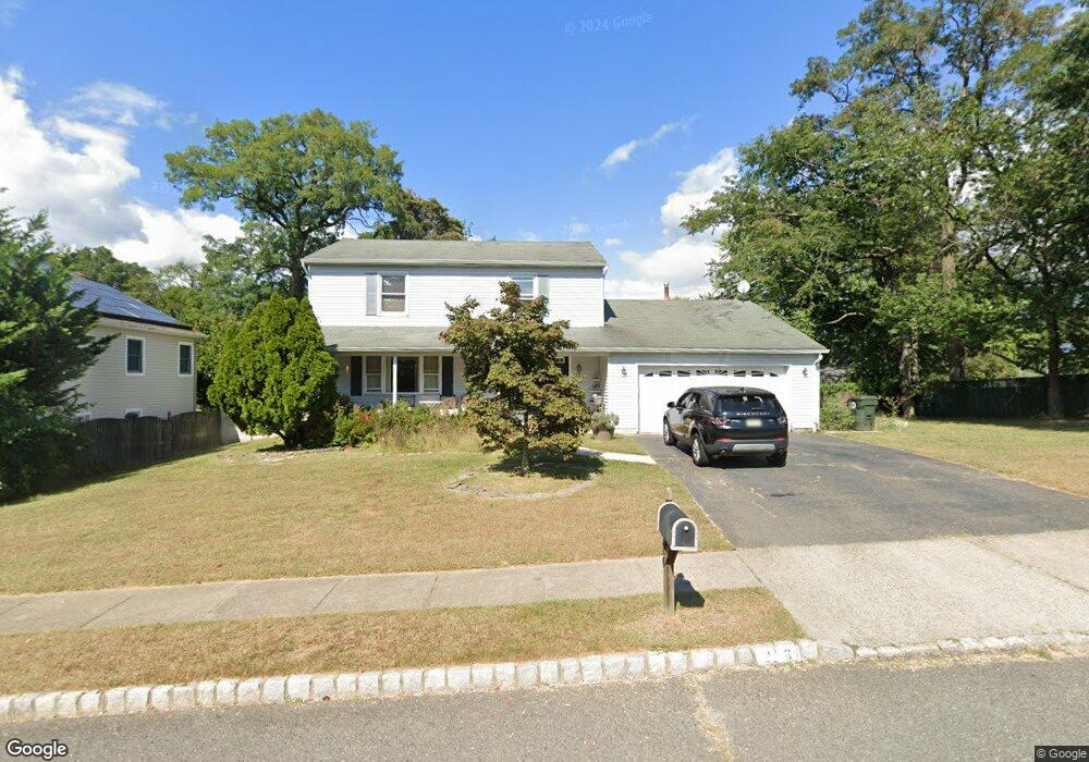
26 Scott Dr Hazlet, NJ 07730
Estimated Value: $689,000 - $830,000
4
Beds
3
Baths
1,950
Sq Ft
$375/Sq Ft
Est. Value
About This Home
This home is located at 26 Scott Dr, Hazlet, NJ 07730 and is currently estimated at $731,275, approximately $375 per square foot. 26 Scott Dr is a home located in Monmouth County with nearby schools including Raritan High School, Baytul-Iman Academy, and St. Ann School.
Ownership History
Date
Name
Owned For
Owner Type
Purchase Details
Closed on
Aug 29, 2003
Sold by
Falzone Debra
Bought by
Hyde Robert and Hyde Maureen
Current Estimated Value
Home Financials for this Owner
Home Financials are based on the most recent Mortgage that was taken out on this home.
Original Mortgage
$300,000
Interest Rate
6.15%
Purchase Details
Closed on
Nov 12, 1998
Sold by
Paul John
Bought by
Falzone Debra
Home Financials for this Owner
Home Financials are based on the most recent Mortgage that was taken out on this home.
Original Mortgage
$146,150
Interest Rate
6.65%
Purchase Details
Closed on
Jul 23, 1996
Sold by
Anderson Ross
Bought by
Paul John
Home Financials for this Owner
Home Financials are based on the most recent Mortgage that was taken out on this home.
Original Mortgage
$195,000
Interest Rate
8.27%
Purchase Details
Closed on
Jan 3, 1994
Sold by
Docheff Daniel
Bought by
Anderson Ross and Anderson Susan
Home Financials for this Owner
Home Financials are based on the most recent Mortgage that was taken out on this home.
Original Mortgage
$140,000
Interest Rate
7%
Create a Home Valuation Report for This Property
The Home Valuation Report is an in-depth analysis detailing your home's value as well as a comparison with similar homes in the area
Home Values in the Area
Average Home Value in this Area
Purchase History
| Date | Buyer | Sale Price | Title Company |
|---|---|---|---|
| Hyde Robert | $379,929 | -- | |
| Falzone Debra | $5,021,100 | -- | |
| Paul John | $205,000 | -- | |
| Anderson Ross | $201,000 | -- |
Source: Public Records
Mortgage History
| Date | Status | Borrower | Loan Amount |
|---|---|---|---|
| Previous Owner | Hyde Robert | $300,000 | |
| Previous Owner | Anderson Ross | $146,150 | |
| Previous Owner | Paul John | $195,000 | |
| Previous Owner | Anderson Ross | $140,000 |
Source: Public Records
Tax History
| Year | Tax Paid | Tax Assessment Tax Assessment Total Assessment is a certain percentage of the fair market value that is determined by local assessors to be the total taxable value of land and additions on the property. | Land | Improvement |
|---|---|---|---|---|
| 2025 | $10,610 | $539,800 | $308,500 | $231,300 |
| 2024 | $10,373 | $504,500 | $274,300 | $230,200 |
Source: Public Records
Map
Nearby Homes
- 3 Lisa Dr
- 78 Liberty Place
- 21 Gary Ave Unit 54
- 26 Gary Ave Unit 59
- 16 Gary Ave Unit 49
- 17 Gary Ave
- 35 Randall Ave Unit 68
- 34 Randall Ave Unit 67
- 32 Randall Ave Unit 65
- 30 Randall Ave Unit 63
- 1 Robin Rd
- 1 Rose Terrace
- 261 State Route 36
- 330 State Route 36
- 101 Hudson Ave
- 116 Hudson Ave
- 22 Avenue D Unit 45
- 22 John St
- 22 John St Unit 137
- 7 John St
Your Personal Tour Guide
Ask me questions while you tour the home.