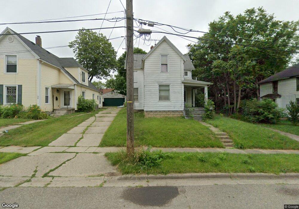
26 Sheridan St Pontiac, MI 48342
Estimated Value: $105,831 - $186,000
4
Beds
2
Baths
1,354
Sq Ft
$110/Sq Ft
Est. Value
About This Home
This home is located at 26 Sheridan St, Pontiac, MI 48342 and is currently estimated at $149,458, approximately $110 per square foot. 26 Sheridan St is a home located in Oakland County with nearby schools including Owen Elementary School, Pontiac Middle School, and Pontiac High School.
Ownership History
Date
Name
Owned For
Owner Type
Purchase Details
Closed on
Jul 31, 2014
Sold by
Shelton Robert and Shelton Loretta
Bought by
Shelton Robert and Shelton Loretta
Current Estimated Value
Purchase Details
Closed on
Nov 21, 2013
Sold by
James Andy
Bought by
Shelton Robert and Shelton Loretta
Purchase Details
Closed on
May 28, 2013
Sold by
James Tina
Bought by
James Andy
Purchase Details
Closed on
Jul 11, 2008
Sold by
James Tina and James Andy
Bought by
Shelton Robert and Shelton Loretta
Purchase Details
Closed on
Jun 23, 2004
Sold by
Shelton Loretta and Hecht Eugene
Bought by
Shelton Robert and Shelton Loretta
Create a Home Valuation Report for This Property
The Home Valuation Report is an in-depth analysis detailing your home's value as well as a comparison with similar homes in the area
Home Values in the Area
Average Home Value in this Area
Purchase History
| Date | Buyer | Sale Price | Title Company |
|---|---|---|---|
| Shelton Robert | -- | None Available | |
| Shelton Robert | -- | None Available | |
| James Andy | -- | None Available | |
| Shelton Robert | -- | Philip R Seaver Title Co Inc | |
| Shelton Robert | -- | -- |
Source: Public Records
Tax History Compared to Growth
Tax History
| Year | Tax Paid | Tax Assessment Tax Assessment Total Assessment is a certain percentage of the fair market value that is determined by local assessors to be the total taxable value of land and additions on the property. | Land | Improvement |
|---|---|---|---|---|
| 2024 | $572 | $30,600 | $0 | $0 |
| 2023 | $545 | $27,270 | $0 | $0 |
| 2022 | $592 | $24,230 | $0 | $0 |
| 2021 | $576 | $21,550 | $0 | $0 |
| 2020 | $495 | $19,790 | $0 | $0 |
| 2019 | $551 | $17,060 | $0 | $0 |
| 2018 | $522 | $14,760 | $0 | $0 |
| 2017 | $498 | $14,380 | $0 | $0 |
| 2016 | $526 | $13,400 | $0 | $0 |
| 2015 | -- | $13,090 | $0 | $0 |
| 2014 | -- | $12,340 | $0 | $0 |
| 2011 | -- | $17,070 | $0 | $0 |
Source: Public Records
Map
Nearby Homes
- 388 N Perry St
- 431 Perry St
- 352 N Perry St
- 25 Elwood St
- 124 Kemp St
- 217 Edison St
- 421 N Paddock St
- 80 Oakhill St
- 52 Whitfield St
- 11 Lexington Place
- 36 Clairmont Place
- 37 Poplar Ave
- 59 Forest St
- 73 Poplar Ave
- 633 N Perry St
- 130 Baldwin Ave
- 100 Oliver St
- 0 Baldwin Rd Unit 20251027987
- 0 Baldwin Ave Unit 20240055811
- 669 N Perry St