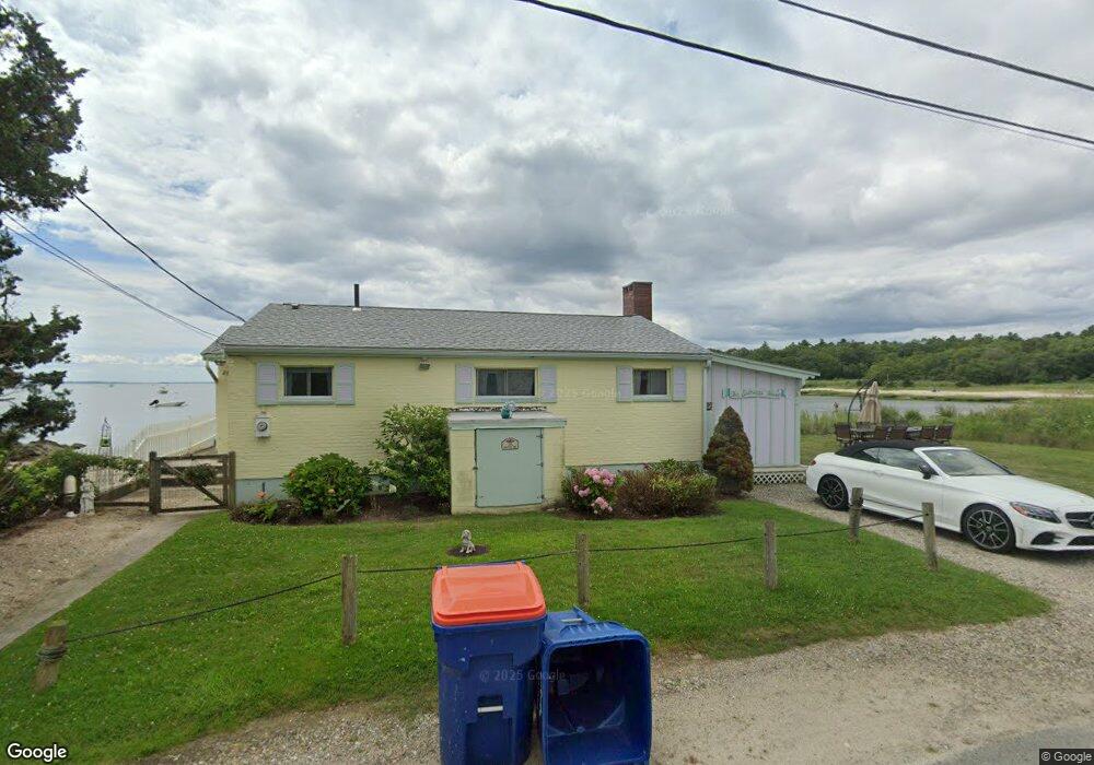
26 Shore Dr Mattapoisett, MA 02739
Estimated Value: $708,000 - $987,000
4
Beds
1
Bath
956
Sq Ft
$857/Sq Ft
Est. Value
About This Home
Charming turnkey-furnished winter rental available in waterfront home with private beach, fenced yard and off-street parking available for ten-month lease, sept. 1 - may 31.
Ownership History
Date
Name
Owned For
Owner Type
Purchase Details
Closed on
May 20, 2015
Sold by
Clark Lisa
Bought by
26 Shore Drive Llc
Current Estimated Value
Purchase Details
Closed on
Nov 7, 2012
Sold by
Clark Putman D and Clark Lisa
Bought by
Clark Lisa
Purchase Details
Closed on
Jan 17, 2006
Sold by
Francis Donald P and Francis Janice C
Bought by
Clark Putnam Damon and Clark Lisa
Purchase Details
Closed on
Feb 5, 1992
Sold by
Cross A Stanley A and Cross Anna B
Bought by
Francis Donald P and Francis Janice C
Home Financials for this Owner
Home Financials are based on the most recent Mortgage that was taken out on this home.
Original Mortgage
$50,000
Interest Rate
8.23%
Mortgage Type
Purchase Money Mortgage
Create a Home Valuation Report for This Property
The Home Valuation Report is an in-depth analysis detailing your home's value as well as a comparison with similar homes in the area
Home Values in the Area
Average Home Value in this Area
Purchase History
| Date | Buyer | Sale Price | Title Company |
|---|---|---|---|
| 26 Shore Drive Llc | -- | -- | |
| 26 Shore Drive Llc | -- | -- | |
| Clark Lisa | -- | -- | |
| Clark Lisa | -- | -- | |
| Clark Putnam Damon | $645,000 | -- | |
| Clark Putnam Damon | $645,000 | -- | |
| Francis Donald P | $97,500 | -- |
Source: Public Records
Mortgage History
| Date | Status | Borrower | Loan Amount |
|---|---|---|---|
| Previous Owner | Francis Donald P | $50,000 |
Source: Public Records
Property History
| Date | Event | Price | List to Sale | Price per Sq Ft |
|---|---|---|---|---|
| 07/23/2025 07/23/25 | Off Market | $2,200 | -- | -- |
| 06/27/2025 06/27/25 | For Rent | $2,200 | -- | -- |
Tax History Compared to Growth
Tax History
| Year | Tax Paid | Tax Assessment Tax Assessment Total Assessment is a certain percentage of the fair market value that is determined by local assessors to be the total taxable value of land and additions on the property. | Land | Improvement |
|---|---|---|---|---|
| 2025 | $6,956 | $646,500 | $523,800 | $122,700 |
| 2024 | $6,787 | $645,800 | $523,800 | $122,000 |
| 2023 | $7,026 | $624,554 | $512,154 | $112,400 |
| 2022 | $6,614 | $533,365 | $426,765 | $106,600 |
| 2021 | $5,995 | $462,600 | $371,100 | $91,500 |
| 2020 | $5,790 | $429,200 | $353,400 | $75,800 |
| 2019 | $5,629 | $426,100 | $353,400 | $72,700 |
| 2018 | $5,959 | $457,700 | $375,300 | $82,400 |
| 2017 | $6,326 | $484,000 | $406,500 | $77,500 |
| 2016 | $6,139 | $465,100 | $390,900 | $74,200 |
| 2015 | $5,645 | $434,200 | $369,000 | $65,200 |
| 2014 | $5,671 | $445,800 | $375,300 | $70,500 |
Source: Public Records
Map
Nearby Homes
- 6 North Rd
- 0 (Lot 2) Hollywoods Rd
- 7 Aucoot Rd
- 85 Moorings Rd
- 0 Converse Rd Unit 73451004
- 13 Converse Rd
- 15 Quelle Ln
- 51 Holly Pond Rd
- 11 Bay Rd
- 0 (Lot D) Angelica Ave
- 8 Channel St
- 11 Cove St
- 4 Olde Logging Rd
- 1 Angelica Ave
- 3 Rock St
- 7 Upland Way
- 6 Ocean Breeze Ln
- 0 Beach St
- 27 Beach St
- 31 Split Rock Ln
- 26 Shore Dr
- 26 Shore Dr
- 30 Shore Dr
- 9 Shore Dr Unit 9
- 9 Shore Dr Unit 1 week rent
- 9 Shore Dr Unit 2 week rent
- 9 Shore Dr
- 11 Shore Dr
- 18 Shore Dr
- 18 Shore Dr Unit n/a
- 8 Harbor Road hb Unit Winter
- 8 Harbor Road hb
- 8 Harbor Road hb Unit vacation
- 8 Harbor Road hb
- 8 Harbor Road hb Unit 1
- 14 Harbor Road hb
- 14 Harbor Road hb Unit seasonal
- 14 Harbor Road hb Unit 1
- 14 Harbor Road hb Unit Winter
- 10 Harbor Road hb