
Seller's Agent in 2025
Brian Garvey
Keller Williams Gateway Realty
(603) 566-8708
9 in this area
44 Total Sales

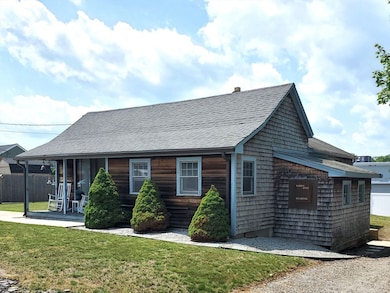


Welcoming ranch style home blending coastal character vibes outside with warm rustic charm inside! The efficient layout feels larger than you might expect and features a cozy den accented with natural beam ceilings flowing to a kitchen with stainless appliances and space for casual dining plus a separate dining area that could double as a 2nd living room or home office. The generous primary BR offers hardwood floors while the 2nd BR includes a bonus nook for storage or extra closet space. First-floor laundry and a spacious bath adds everyday ease, and the partially finished basement includes a new 200amp panel +plumbing for a half bath—easily completed for an additional 800±SF. Unwind outdoors on the inviting farmer’s porch or entertain on the low maintenance lawn that’s begging for birthday parties & BBQ’s! Value, comfort and a convenient location close to shopping & amenities make a great combination for those seeking easy single-level living & buyers ready to start building equity!
| Date | Type | Sale Price | Title Company |
|---|---|---|---|
| Deed | $379,000 | -- | |
| Deed | $300,000 | -- | |
| Deed | $300,000 | -- | |
| Deed | $300,000 | -- | |
| Deed | $300,000 | -- |
| Date | Status | Loan Amount | Loan Type |
|---|---|---|---|
| Open | $360,050 | New Conventional | |
| Previous Owner | $55,000 | No Value Available | |
| Previous Owner | $255,000 | Purchase Money Mortgage | |
| Previous Owner | $36,459 | No Value Available |
| Date | Event | Price | List to Sale | Price per Sq Ft |
|---|---|---|---|---|
| 09/17/2025 09/17/25 | Sold | $379,000 | 0.0% | $369 / Sq Ft |
| 08/04/2025 08/04/25 | Pending | -- | -- | -- |
| 07/31/2025 07/31/25 | For Sale | $379,000 | 0.0% | $369 / Sq Ft |
| 07/22/2025 07/22/25 | Pending | -- | -- | -- |
| 07/16/2025 07/16/25 | For Sale | $379,000 | -- | $369 / Sq Ft |
| Year | Tax Paid | Tax Assessment Tax Assessment Total Assessment is a certain percentage of the fair market value that is determined by local assessors to be the total taxable value of land and additions on the property. | Land | Improvement |
|---|---|---|---|---|
| 2025 | $2,610 | $207,800 | $122,400 | $85,400 |
| 2024 | $2,488 | $193,500 | $111,700 | $81,800 |
| 2023 | $2,356 | $180,500 | $106,400 | $74,100 |
| 2022 | $2,247 | $159,600 | $88,700 | $70,900 |
| 2021 | $2,213 | $153,600 | $88,700 | $64,900 |
| 2020 | $2,083 | $146,500 | $88,700 | $57,800 |
| 2019 | $2,059 | $144,900 | $88,700 | $56,200 |
| 2018 | $1,990 | $138,100 | $89,500 | $48,600 |
| 2017 | $1,970 | $137,400 | $89,500 | $47,900 |
| 2016 | $1,982 | $138,700 | $93,100 | $45,600 |
| 2015 | $1,900 | $133,300 | $89,500 | $43,800 |
| 2014 | $1,893 | $129,100 | $86,400 | $42,700 |
Seller's Agent in 2025
Brian Garvey
Keller Williams Gateway Realty
(603) 566-8708
9 in this area
44 Total Sales
O
Buyer's Agent in 2025
Olivia Campbell
Keller Williams Elite
(617) 767-1461
1 in this area
2 Total Sales
Source: MLS Property Information Network (MLS PIN)
MLS Number: 73405247
APN: BELL-000094-000185
Disclaimer: Certain information contained herein is derived from information provided by parties other than Homes.com. All information provided is deemed reliable, but is not guaranteed to be accurate and should be independently verified.
![]() The property listing data and information, or the Images, set forth herein were provided to MLS Property Information Network, Inc. from third party sources, including sellers, lessors and public records, and were compiled by MLS Property Information Network, Inc. The property listing data and information, and the Images, are for the personal, non-commercial use of consumers having a good faith interest in purchasing or leasing listed properties of the type displayed to them and may not be used for any purpose other than to identify prospective properties which such consumers may have a good faith interest in purchasing or leasing. MLS Property Information Network, Inc. and its subscribers disclaim any and all representations and warranties as to the accuracy of the property listing data and information, or as to the accuracy of any of the Images, set forth herein.
The property listing data and information, or the Images, set forth herein were provided to MLS Property Information Network, Inc. from third party sources, including sellers, lessors and public records, and were compiled by MLS Property Information Network, Inc. The property listing data and information, and the Images, are for the personal, non-commercial use of consumers having a good faith interest in purchasing or leasing listed properties of the type displayed to them and may not be used for any purpose other than to identify prospective properties which such consumers may have a good faith interest in purchasing or leasing. MLS Property Information Network, Inc. and its subscribers disclaim any and all representations and warranties as to the accuracy of the property listing data and information, or as to the accuracy of any of the Images, set forth herein.