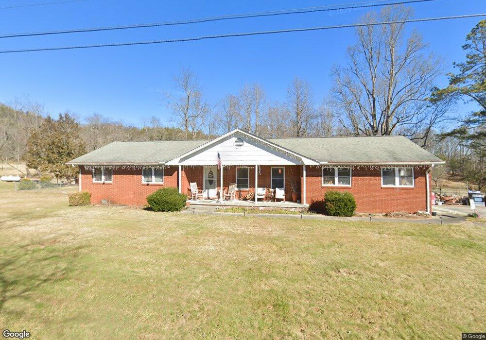
260 Bob Mark Trail Rabun Gap, GA 30568
Estimated Value: $266,780 - $344,000
3
Beds
2
Baths
1,352
Sq Ft
$222/Sq Ft
Est. Value
About This Home
This home is located at 260 Bob Mark Trail, Rabun Gap, GA 30568 and is currently estimated at $300,695, approximately $222 per square foot. 260 Bob Mark Trail is a home located in Rabun County with nearby schools including Rabun County Primary School, Rabun County High School, and Rabun Gap Nacoochee School.
Ownership History
Date
Name
Owned For
Owner Type
Purchase Details
Closed on
Aug 2, 2013
Sold by
Lee Wai Ha
Bought by
Ray Linda Williams
Current Estimated Value
Purchase Details
Closed on
Apr 1, 1990
Bought by
Lee Lap Chung and Wai Ha Lee
Purchase Details
Closed on
Oct 1, 1975
Purchase Details
Closed on
Apr 1, 1974
Purchase Details
Closed on
May 1, 1973
Create a Home Valuation Report for This Property
The Home Valuation Report is an in-depth analysis detailing your home's value as well as a comparison with similar homes in the area
Home Values in the Area
Average Home Value in this Area
Purchase History
| Date | Buyer | Sale Price | Title Company |
|---|---|---|---|
| Ray Linda Williams | $65,000 | -- | |
| Ray Linda Williams | $65,000 | -- | |
| Lee Lap Chung | $60,000 | -- | |
| Lee Lap Chung | $60,000 | -- | |
| -- | $32,500 | -- | |
| -- | $32,500 | -- | |
| -- | -- | -- | |
| -- | $32,500 | -- | |
| -- | $32,500 | -- |
Source: Public Records
Tax History Compared to Growth
Tax History
| Year | Tax Paid | Tax Assessment Tax Assessment Total Assessment is a certain percentage of the fair market value that is determined by local assessors to be the total taxable value of land and additions on the property. | Land | Improvement |
|---|---|---|---|---|
| 2025 | $1,100 | $68,538 | $10,000 | $58,538 |
| 2024 | $1,043 | $64,954 | $10,000 | $54,954 |
| 2023 | $1,024 | $55,954 | $10,000 | $45,954 |
| 2022 | $995 | $54,355 | $10,000 | $44,355 |
| 2021 | $924 | $49,286 | $10,000 | $39,286 |
| 2020 | $689 | $35,521 | $8,000 | $27,521 |
| 2019 | $694 | $35,521 | $8,000 | $27,521 |
| 2018 | $696 | $35,521 | $8,000 | $27,521 |
| 2017 | $668 | $35,521 | $8,000 | $27,521 |
| 2016 | $670 | $35,521 | $8,000 | $27,521 |
| 2015 | $679 | $35,236 | $8,000 | $27,236 |
| 2014 | $503 | $36,364 | $10,000 | $26,364 |
Source: Public Records
Map
Nearby Homes
- 137 Olds Mountain Peak Rd
- 243 Degroff Ln
- 786 Hope Haven Ln
- 0 John Beck Dockins Rd Unit 10606531
- 0 Ov Justus Rd
- 1422 Wolffork Rd
- 5192 Wolffork Rd
- 0 Uplander Unit 10628218
- 0 Uplander Unit M181832
- 0 Wolffork Rd Unit 10624471
- 153 Coleman Heights Ln
- 0 N U S 441 NW Unit 10489249
- 108 Olds Mountain Peak Rd
- 784 Wolffork Church Rd
- 52 Lucky Ln
- 0 Us-441 S Unit 10226435
- 208 Colony Rd
- 5019 Wolffork Rd
- 0 Stella Ln Unit 10485082
- 476 Franklin St
- 230 Bob Mark Trail
- 310 Bob Mark Trail
- 202 Bob Mark Trail
- 411 Bob Mark Trail
- 80 Lynn Ann Ln
- 0 Sandy Ln Unit Lot 8 8285208
- 0 Sandy Ln Unit 8 8056245
- 30 Cathy Parker Ln
- 85 Sandy Ln
- 2 Cathy Parker Ln
- 430 Bob Mark Trail
- 021 Meadow Brook Ln Unit 21
- 0 Shake Hollow Unit Lot 214 8389439
- 0 Shake Hollow Unit LT 227 3134547
- 0 Shake Hollow Unit LT 212 3134543
- 0 Shake Hollow Unit LT 226 3134538
- 0 Shake Hollow Unit LT 224 3134531
- 0 Shake Hollow Unit LT 214 3134536
- 0 Shake Hollow Unit LT 202 3134519
- 0 Shake Hollow Unit LT 219 3134512