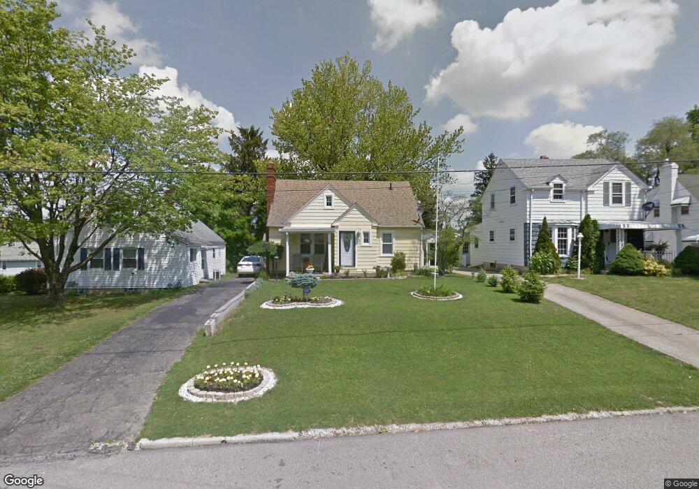
260 Walter Ave Mansfield, OH 44903
Estimated Value: $80,000 - $119,000
3
Beds
1
Bath
1,160
Sq Ft
$82/Sq Ft
Est. Value
About This Home
This home is located at 260 Walter Ave, Mansfield, OH 44903 and is currently estimated at $95,103, approximately $81 per square foot. 260 Walter Ave is a home located in Richland County with nearby schools including St. Peter's High School/Junior High, St. Peter's Elementary/Montessori School, and Discovery School.
Ownership History
Date
Name
Owned For
Owner Type
Purchase Details
Closed on
Sep 9, 2019
Sold by
Merwine Larry D
Bought by
Laji Properties Of Mansfield Llc
Current Estimated Value
Purchase Details
Closed on
Nov 29, 2016
Sold by
Wells Fargo Bank Na
Bought by
Merwine Larry D
Purchase Details
Closed on
Sep 9, 2016
Sold by
Spreng Jack D
Bought by
Wells Fargo Bank Na
Purchase Details
Closed on
Dec 5, 2007
Sold by
Wells Fargo Bank Na
Bought by
Spreng Jack D
Home Financials for this Owner
Home Financials are based on the most recent Mortgage that was taken out on this home.
Original Mortgage
$58,974
Interest Rate
6.13%
Mortgage Type
FHA
Purchase Details
Closed on
Mar 29, 2007
Sold by
Coombs Nelson
Bought by
Wells Fargo Bank Na
Purchase Details
Closed on
Sep 3, 2004
Sold by
Welch Dale R and Welch Linda L
Bought by
Coombs Nelson D
Home Financials for this Owner
Home Financials are based on the most recent Mortgage that was taken out on this home.
Original Mortgage
$79,000
Interest Rate
8.5%
Mortgage Type
Credit Line Revolving
Purchase Details
Closed on
Mar 4, 2004
Sold by
The Bank Of New York
Bought by
Welch Dale R and Welch Linda L
Purchase Details
Closed on
Feb 6, 2003
Sold by
Lambert Charles D
Bought by
The Bank Of New York
Purchase Details
Closed on
May 28, 1999
Sold by
Tommelleo Robert J
Bought by
Lambert Charles D
Home Financials for this Owner
Home Financials are based on the most recent Mortgage that was taken out on this home.
Original Mortgage
$63,665
Interest Rate
6.92%
Mortgage Type
FHA
Purchase Details
Closed on
Oct 3, 1997
Sold by
Grogoza Marijan E
Bought by
Tommelleo Robert J and Tommelleo Heather S
Home Financials for this Owner
Home Financials are based on the most recent Mortgage that was taken out on this home.
Original Mortgage
$49,400
Interest Rate
7.54%
Mortgage Type
FHA
Purchase Details
Closed on
Dec 1, 1985
Create a Home Valuation Report for This Property
The Home Valuation Report is an in-depth analysis detailing your home's value as well as a comparison with similar homes in the area
Home Values in the Area
Average Home Value in this Area
Purchase History
| Date | Buyer | Sale Price | Title Company |
|---|---|---|---|
| Laji Properties Of Mansfield Llc | -- | None Available | |
| Merwine Larry D | $250 | Southern Title | |
| Wells Fargo Bank Na | $34,000 | None Available | |
| Spreng Jack D | $59,900 | Prism Title & Closing Servic | |
| Wells Fargo Bank Na | $48,000 | None Available | |
| Coombs Nelson D | $79,000 | Southern Title | |
| Welch Dale R | $38,000 | -- | |
| The Bank Of New York | $36,000 | -- | |
| Lambert Charles D | $63,800 | -- | |
| Tommelleo Robert J | $49,000 | -- | |
| -- | $35,000 | -- |
Source: Public Records
Mortgage History
| Date | Status | Borrower | Loan Amount |
|---|---|---|---|
| Previous Owner | Spreng Jack D | $58,974 | |
| Previous Owner | Coombs Nelson D | $79,000 | |
| Previous Owner | Lambert Charles D | $63,665 | |
| Previous Owner | Tommelleo Robert J | $49,400 |
Source: Public Records
Tax History Compared to Growth
Tax History
| Year | Tax Paid | Tax Assessment Tax Assessment Total Assessment is a certain percentage of the fair market value that is determined by local assessors to be the total taxable value of land and additions on the property. | Land | Improvement |
|---|---|---|---|---|
| 2024 | $709 | $14,800 | $3,070 | $11,730 |
| 2023 | $709 | $14,800 | $3,070 | $11,730 |
| 2022 | $614 | $10,740 | $2,500 | $8,240 |
| 2021 | $618 | $10,740 | $2,500 | $8,240 |
| 2020 | $632 | $10,740 | $2,500 | $8,240 |
| 2019 | $700 | $10,740 | $2,500 | $8,240 |
| 2018 | $125 | $10,740 | $2,500 | $8,240 |
| 2017 | $338 | $14,270 | $2,500 | $11,770 |
| 2016 | $789 | $20,970 | $3,320 | $17,650 |
| 2015 | $737 | $20,970 | $3,320 | $17,650 |
| 2014 | $727 | $20,970 | $3,320 | $17,650 |
| 2012 | $302 | $22,060 | $3,490 | $18,570 |
Source: Public Records
Map
Nearby Homes
- 257 Wood St
- 353 Sturges Ave
- 0 Cline Ave Hedeen Abbeyfeale Unit 9066362
- 120 Grover St
- 172 -172 1 2 Lexington Ave
- 505 Wood St
- 135 Wood St
- 137 Lexington Ave
- 96 Glenwood Heights
- 131 Sturges Ave
- 118 Lind Ave
- 186 S Mulberry St
- 114 Vennum Ave
- 286 S Main St
- 394 S Main St
- 212 S Main St
- 470 Lexington Ave
- 259 S Main St
- 37 W Arch St
- 327 Hammond Ave