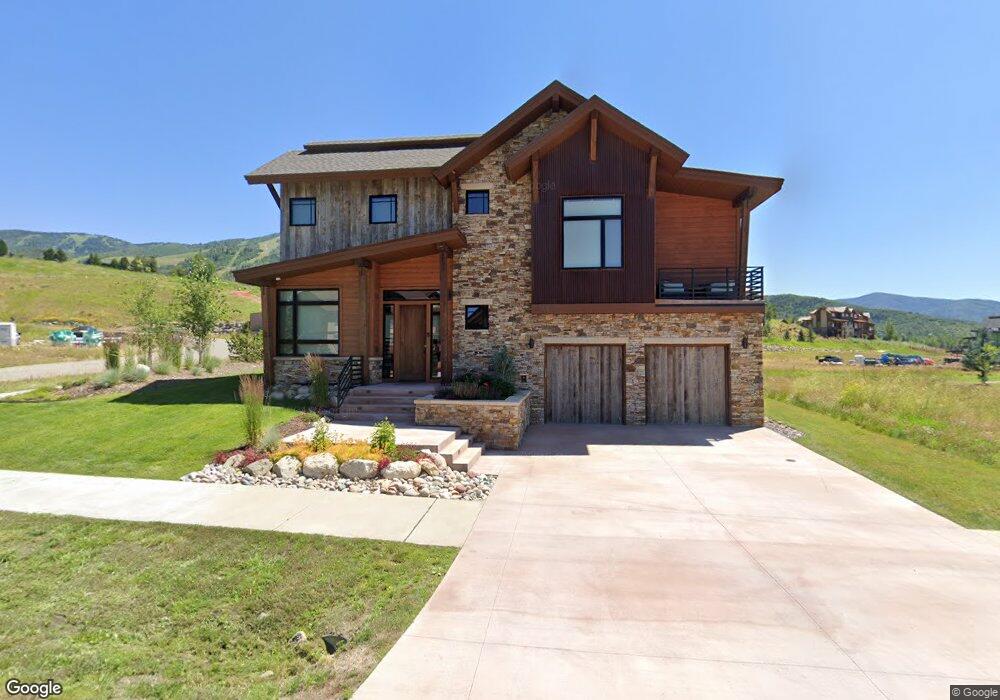
2600 Bronc Buster Loop Steamboat Springs, CO 80487
Estimated Value: $4,125,463 - $4,948,000
4
Beds
5
Baths
2,431
Sq Ft
$1,845/Sq Ft
Est. Value
About This Home
This home is located at 2600 Bronc Buster Loop, Steamboat Springs, CO 80487 and is currently estimated at $4,485,866, approximately $1,845 per square foot. 2600 Bronc Buster Loop is a home located in Routt County with nearby schools including Strawberry Park Elementary School, Steamboat Springs Middle School, and Steamboat Springs High School.
Ownership History
Date
Name
Owned For
Owner Type
Purchase Details
Closed on
Mar 24, 2025
Sold by
Doran Steven W and Doran Ellen J
Bought by
Jacobson Living Trust
Current Estimated Value
Purchase Details
Closed on
Apr 1, 2015
Sold by
Lrv Enterprise Llc
Bought by
Doran Steven W
Home Financials for this Owner
Home Financials are based on the most recent Mortgage that was taken out on this home.
Original Mortgage
$60,000
Interest Rate
3.82%
Mortgage Type
Purchase Money Mortgage
Create a Home Valuation Report for This Property
The Home Valuation Report is an in-depth analysis detailing your home's value as well as a comparison with similar homes in the area
Home Values in the Area
Average Home Value in this Area
Purchase History
| Date | Buyer | Sale Price | Title Company |
|---|---|---|---|
| Jacobson Living Trust | $4,650,000 | Land Title | |
| Doran Steven W | $230,000 | Heritage Title |
Source: Public Records
Mortgage History
| Date | Status | Borrower | Loan Amount |
|---|---|---|---|
| Previous Owner | Doran Steven W | $60,000 |
Source: Public Records
Tax History Compared to Growth
Tax History
| Year | Tax Paid | Tax Assessment Tax Assessment Total Assessment is a certain percentage of the fair market value that is determined by local assessors to be the total taxable value of land and additions on the property. | Land | Improvement |
|---|---|---|---|---|
| 2024 | $8,886 | $211,980 | $42,480 | $169,500 |
| 2023 | $8,886 | $211,980 | $42,480 | $169,500 |
| 2022 | $7,241 | $131,190 | $25,020 | $106,170 |
| 2021 | $7,372 | $134,970 | $25,740 | $109,230 |
| 2020 | $6,094 | $112,350 | $23,240 | $89,110 |
| 2019 | $5,943 | $112,350 | $0 | $0 |
| 2018 | $4,942 | $99,030 | $0 | $0 |
| 2017 | $1,733 | $35,160 | $0 | $0 |
| 2016 | $2,506 | $55,100 | $55,100 | $0 |
| 2015 | $2,451 | $55,100 | $55,100 | $0 |
| 2014 | $3,035 | $65,250 | $65,250 | $0 |
| 2012 | -- | $87,000 | $87,000 | $0 |
Source: Public Records
Map
Nearby Homes
- 2648 Bronc Buster Loop
- 2545 Cattle Kate Cir Unit 3207
- 2545 Cattle Kate Cir Unit 3202
- 2525 Cattle Kate Cir Unit 4108
- 2687 Bronc Buster Loop
- 1240 Eagle Glen Dr
- 1301 Eagle Glen Dr
- 2600 Eagleridge Dr Unit 26
- 1223 Urban Way
- 1175 Bangtail Way Unit 4107
- 1175 Bangtail Way Unit 4110
- 1175 Bangtail Way Unit 5112
- 1175 Bangtail Way Unit 2109
- 1175 Bangtail Way Unit 4103
- 2894 Owl Hoot Trail
- 2800 Eagle Ridge Dr Unit C-1
- 1355 Walton Creek Rd Unit 21
- 1355 Walton Creek Rd Unit 20
- 1587 Broomtail Ln Unit A1
- 1585 Broomtail Ln Unit A2
- 2612 Bronc Buster Loop
- 2796 Bronc Buster Loop
- 2784 Bronc Buster Loop
- 2624 Bronc Buster Loop
- 2605 Bronc Buster Loop
- 2613 Bronc Buster Loop
- 2772 Bronc Buster Loop
- 2621 Bronc Buster Loop
- 2636 Bronc Buster Loop
- 0 Bronc Buster Loop
- 2545 Cattle Kate Circle #3108
- 2545 Cattle Kate Cir #3103
- 2545 Cattle Kate Cir #3108 Unit 3108 First Tracks
- 2545 Cattle Kate Circle #3110
- 2560 Flat Tops Ct
- 2791 Bronc Buster Loop Unit LOT 1, WILDHORSE MEA