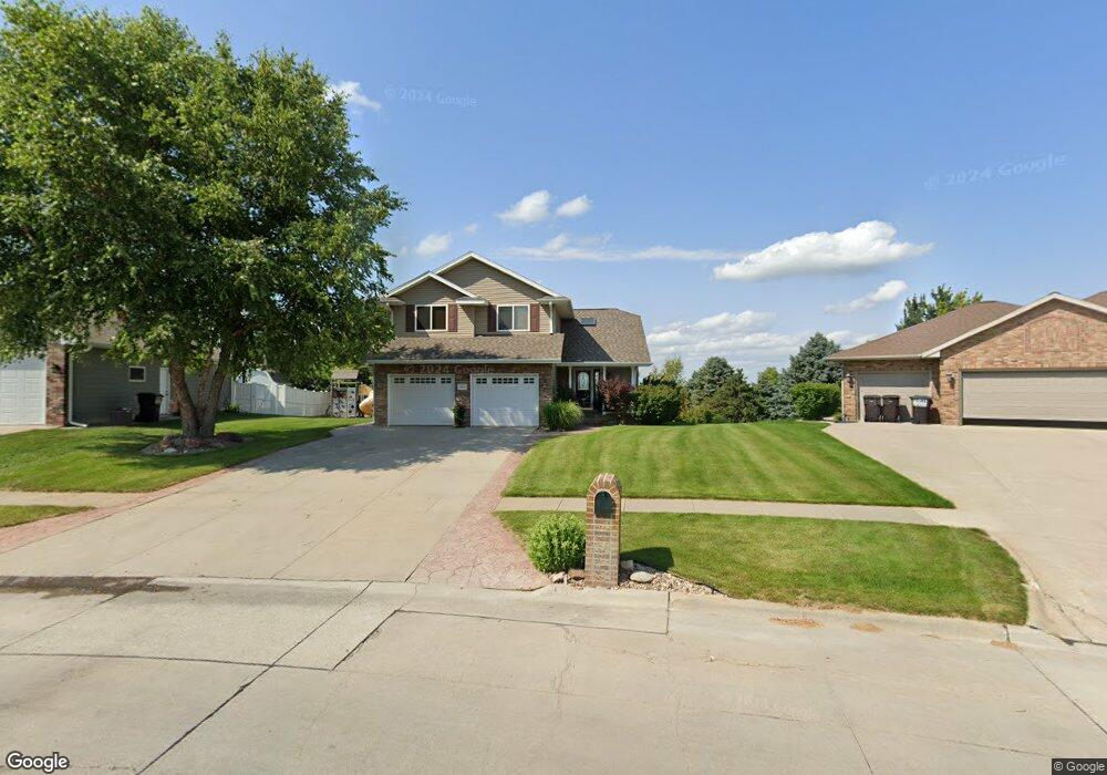
2600 Mimick Dr Norfolk, NE 68701
Estimated Value: $370,193 - $504,000
3
Beds
4
Baths
1,860
Sq Ft
$241/Sq Ft
Est. Value
About This Home
This home is located at 2600 Mimick Dr, Norfolk, NE 68701 and is currently estimated at $448,048, approximately $240 per square foot. 2600 Mimick Dr is a home located in Madison County with nearby schools including Norfolk Senior High School, St. Paul's Lutheran School, and Norfolk Catholic School.
Ownership History
Date
Name
Owned For
Owner Type
Purchase Details
Closed on
Oct 25, 2010
Sold by
Berner Brent J and Berner Amy M
Bought by
Schoenherr Abraham K and Schoenherr Elizabeth K
Current Estimated Value
Home Financials for this Owner
Home Financials are based on the most recent Mortgage that was taken out on this home.
Original Mortgage
$170,000
Outstanding Balance
$112,961
Interest Rate
4.41%
Mortgage Type
New Conventional
Estimated Equity
$335,087
Purchase Details
Closed on
May 11, 2001
Sold by
Carlberg James R and Carlberg Leisa L
Bought by
Berner Brent J and Berner Amy M
Create a Home Valuation Report for This Property
The Home Valuation Report is an in-depth analysis detailing your home's value as well as a comparison with similar homes in the area
Home Values in the Area
Average Home Value in this Area
Purchase History
| Date | Buyer | Sale Price | Title Company |
|---|---|---|---|
| Schoenherr Abraham K | $248,000 | Ne Nebr Title | |
| Berner Brent J | $172,500 | -- |
Source: Public Records
Mortgage History
| Date | Status | Borrower | Loan Amount |
|---|---|---|---|
| Open | Schoenherr Abraham K | $170,000 |
Source: Public Records
Tax History Compared to Growth
Tax History
| Year | Tax Paid | Tax Assessment Tax Assessment Total Assessment is a certain percentage of the fair market value that is determined by local assessors to be the total taxable value of land and additions on the property. | Land | Improvement |
|---|---|---|---|---|
| 2024 | $3,685 | $298,609 | $24,553 | $274,056 |
| 2023 | $5,234 | $283,096 | $24,553 | $258,543 |
| 2022 | $4,892 | $263,945 | $24,553 | $239,392 |
| 2021 | $4,517 | $244,179 | $24,553 | $219,626 |
| 2020 | $4,504 | $244,179 | $24,553 | $219,626 |
| 2019 | $4,353 | $227,910 | $24,553 | $203,357 |
| 2018 | $4,281 | $227,910 | $24,553 | $203,357 |
| 2017 | $4,036 | $214,606 | $24,553 | $190,053 |
| 2016 | $3,780 | $200,567 | $22,947 | $177,620 |
| 2015 | $3,781 | $200,567 | $22,947 | $177,620 |
| 2014 | $3,729 | $192,109 | $22,947 | $169,162 |
| 2013 | $3,628 | $181,042 | $22,947 | $158,095 |
Source: Public Records
Map
Nearby Homes
- 2202 N 26th St
- 2201 N 26th St
- 2203 Blackberry Dr
- 2806 Sheridan Dr
- 1705 W Berry Hill Dr
- 2206 Elmers Ln
- 1906 N 30th St
- 1637 Hackberry Dr
- 2116 Sheridan Dr
- 1706 Homewood Dr Unit 2114 Collegeview
- 1704 Homewood Dr
- 3306 Dover Dr
- 109 Kings Way
- 2304 Highland Dr
- 802 Ferguson Dr
- 3107 Golf View Dr
- 1508 Homewood Dr
- 2001 Alaska Ave
- 1603 Charolais Dr
- 3201 Golf View Dr
- 2602 Mimick Dr
- 2008 N 26th St
- 2604 Mimick Dr
- 2601 Mimick Dr
- 2006 N 26th St
- 2606 Mimick Dr
- 2605 Mimick Dr
- 2004 N 26th St
- 2005 N 26th St
- 2004 Mulberry Dr
- 2700 Mimick Dr
- 2600 Sheridan Dr
- 2002 N 26th St
- 2003 N 26th St
- 2002 Mulberry Dr
- 2007 Mulberry Dr
- 2500 Alaska Ave
- 2702 Mimick Dr
- 2001 N 26th St
- 2005 Mulberry Dr