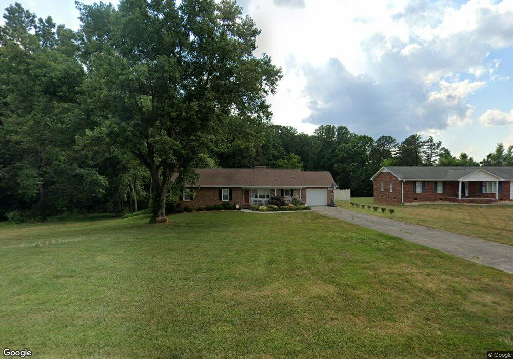
2600 Shieldale Dr Winston Salem, NC 27107
Estimated Value: $294,000 - $319,000
3
Beds
2
Baths
1,753
Sq Ft
$175/Sq Ft
Est. Value
About This Home
This home is located at 2600 Shieldale Dr, Winston Salem, NC 27107 and is currently estimated at $306,549, approximately $174 per square foot. 2600 Shieldale Dr is a home located in Forsyth County with nearby schools including Hall-Woodward Elementary School, Southeast Middle School, and R.B. Glenn High School.
Ownership History
Date
Name
Owned For
Owner Type
Purchase Details
Closed on
Mar 21, 2022
Sold by
Policelli and Anthony
Bought by
Policelli Carol
Current Estimated Value
Purchase Details
Closed on
Jun 30, 2006
Sold by
Marler Stephen V and Marler Polly W
Bought by
Policelli Anthony and Policelli Carol
Home Financials for this Owner
Home Financials are based on the most recent Mortgage that was taken out on this home.
Original Mortgage
$110,900
Interest Rate
6.55%
Mortgage Type
Purchase Money Mortgage
Create a Home Valuation Report for This Property
The Home Valuation Report is an in-depth analysis detailing your home's value as well as a comparison with similar homes in the area
Home Values in the Area
Average Home Value in this Area
Purchase History
| Date | Buyer | Sale Price | Title Company |
|---|---|---|---|
| Policelli Carol | -- | Craige Jenkins Liipfert & Walk | |
| Policelli Anthony | $166,000 | None Available |
Source: Public Records
Mortgage History
| Date | Status | Borrower | Loan Amount |
|---|---|---|---|
| Previous Owner | Policelli Anthony | $110,900 |
Source: Public Records
Tax History Compared to Growth
Tax History
| Year | Tax Paid | Tax Assessment Tax Assessment Total Assessment is a certain percentage of the fair market value that is determined by local assessors to be the total taxable value of land and additions on the property. | Land | Improvement |
|---|---|---|---|---|
| 2025 | $2,764 | $305,900 | $46,000 | $259,900 |
| 2024 | $2,637 | $197,000 | $30,000 | $167,000 |
| 2023 | $2,637 | $197,000 | $30,000 | $167,000 |
| 2022 | $2,588 | $197,000 | $30,000 | $167,000 |
| 2021 | $2,542 | $197,000 | $30,000 | $167,000 |
| 2020 | $2,426 | $175,700 | $22,800 | $152,900 |
| 2019 | $2,444 | $175,700 | $22,800 | $152,900 |
| 2018 | $2,321 | $175,700 | $22,800 | $152,900 |
| 2016 | $1,629 | $123,829 | $22,050 | $101,779 |
| 2015 | $1,604 | $123,829 | $22,050 | $101,779 |
| 2014 | $1,556 | $123,829 | $22,050 | $101,779 |
Source: Public Records
Map
Nearby Homes
- Ashe Plan at Robindale
- Erie Plan at Robindale
- Camden Plan at Robindale
- Durham Plan at Robindale
- Avery Plan at Robindale
- Cary Plan at Robindale
- Carolina Plan at Robindale
- 3598 Robindale Dr
- 3471 Robindale Dr
- 3453 Robindale Dr
- 411 Motif Ln
- 3447 Robindale Dr
- 3458 Robindale Dr
- 3441 Robindale Dr
- 3435 Robindale Dr
- 421 Robindale Ct
- 3428 Robindale Dr
- 3422 Robindale Dr
- 6045 Yeaton Glen Dr
- 6080 Yeaton Glen Dr
- 2590 Shieldale Dr
- 2599 Shieldale Dr
- 2610 Shieldale Dr
- 2620 Shieldale Dr
- 2630 Shieldale Dr
- 3945 Sweetwater Dr
- 2635 Shieldale Dr
- 2645 Shieldale Dr
- 2650 Shieldale Dr
- 3948 Sweetwater Dr
- 3944 Sweetwater Dr
- 2655 Shieldale Dr
- 2607 Meadowood Dr
- 2660 Shieldale Dr
- 3947 Welco St
- 3943 Welco St
- 2675 Shieldale Dr
- 2616 Meadowood Dr
- 2685 Shieldale Dr
- 3942 Welco St