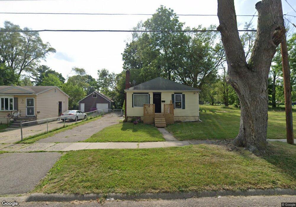
2601 Burns St Flint, MI 48506
Eastside NeighborhoodEstimated Value: $24,000 - $46,000
2
Beds
1
Bath
780
Sq Ft
$47/Sq Ft
Est. Value
About This Home
This home is located at 2601 Burns St, Flint, MI 48506 and is currently estimated at $37,021, approximately $47 per square foot. 2601 Burns St is a home located in Genesee County with nearby schools including Potter School, Richfield Public School Academy, and Flint Cultural Center Academy.
Ownership History
Date
Name
Owned For
Owner Type
Purchase Details
Closed on
Jun 2, 2009
Sold by
Greater Eastside Community Association
Bought by
Shelter Of Flint Inc
Current Estimated Value
Purchase Details
Closed on
Mar 27, 2007
Sold by
Genesee County Land Bank Authority
Bought by
Greater Eastside Community Assn
Purchase Details
Closed on
Dec 21, 2004
Sold by
Kildee Daniel T and Genesee County Treasurer
Bought by
Genesee County Land Bank Authority
Purchase Details
Closed on
Mar 28, 2001
Sold by
Mcmillan Steven and First Finance
Bought by
Bankers Trust Company Of California Na
Create a Home Valuation Report for This Property
The Home Valuation Report is an in-depth analysis detailing your home's value as well as a comparison with similar homes in the area
Home Values in the Area
Average Home Value in this Area
Purchase History
| Date | Buyer | Sale Price | Title Company |
|---|---|---|---|
| Shelter Of Flint Inc | $55,000 | Guaranty Title Company | |
| Greater Eastside Community Assn | $6,000 | First American Title Ins Co | |
| Genesee County Land Bank Authority | -- | -- | |
| Bankers Trust Company Of California Na | $25,500 | -- |
Source: Public Records
Tax History
| Year | Tax Paid | Tax Assessment Tax Assessment Total Assessment is a certain percentage of the fair market value that is determined by local assessors to be the total taxable value of land and additions on the property. | Land | Improvement |
|---|---|---|---|---|
| 2025 | $630 | $12,600 | $0 | $0 |
| 2024 | $595 | $7,200 | $0 | $0 |
| 2023 | $744 | $9,500 | $0 | $0 |
| 2022 | $0 | $7,700 | $0 | $0 |
| 2021 | $750 | $7,400 | $0 | $0 |
| 2020 | $698 | $6,600 | $0 | $0 |
| 2019 | $701 | $6,600 | $0 | $0 |
| 2018 | $661 | $6,300 | $0 | $0 |
| 2017 | $752 | $0 | $0 | $0 |
| 2016 | $774 | $0 | $0 | $0 |
| 2015 | -- | $0 | $0 | $0 |
| 2014 | -- | $0 | $0 | $0 |
| 2012 | -- | $10,900 | $0 | $0 |
Source: Public Records
Map
Nearby Homes
- 2506 Arlington Ave
- 2217 Maryland Ave
- 2321 Levern St
- 2426 Hoff St
- 1721 New York Ave
- 2426 Broadway Blvd
- 2211 Torrance St
- 1805 Bennett Ave
- 1730 Oklahoma Ave
- 1733 Oklahoma Ave
- 1629 New York Ave
- 1805 Montana Ave
- 2908 Douglas Ave
- 2701 Branch Rd
- 3018 Dakota Ave
- 1623 Montana Ave
- 1622 Arlington Ave
- 2719 Branch Rd
- 2601 Illinois Ave
- 1513 Jane Ave
- 2605 Burns St
- 2513 Burns St
- 2609 Burns St
- 2509 Burns St
- 2600 N Vernon Ave
- 2518 N Vernon Ave
- 2604 N Vernon Ave
- 2613 Burns St
- 2512 N Vernon Ave
- 2608 N Vernon Ave
- 2505 Burns St
- 2510 N Vernon Ave
- 2506 N Vernon Ave
- 2501 Burns St
- 2500 N Vernon Ave
- 2600 Cook St Unit Bldg-Unit
- 2600 Cook St
- 2604 Cook St
- 2217 Delaware Ave
- 2213 Delaware Ave
Your Personal Tour Guide
Ask me questions while you tour the home.