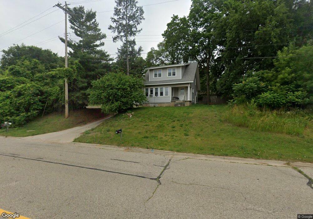
2601 Hillside Dr NW Grand Rapids, MI 49544
Estimated Value: $283,000 - $328,612
3
Beds
2
Baths
1,850
Sq Ft
$162/Sq Ft
Est. Value
About This Home
This home is located at 2601 Hillside Dr NW, Grand Rapids, MI 49544 and is currently estimated at $299,153, approximately $161 per square foot. 2601 Hillside Dr NW is a home located in Kent County with nearby schools including Kenowa Hills Central Elementary School, Kenowa Hills Middle School, and Kenowa Hills High School.
Ownership History
Date
Name
Owned For
Owner Type
Purchase Details
Closed on
Aug 22, 2019
Sold by
Miller Peter and Whitehead Pamela
Bought by
Living Grand Llc
Current Estimated Value
Purchase Details
Closed on
Dec 16, 2013
Sold by
Whitehead Pamela A
Bought by
Miller B Pete and Whitehead Pamela A
Purchase Details
Closed on
Jul 2, 1993
Sold by
Ward Robert S and Ward Evelyn C
Bought by
Whitehead Pamela A and Miller Pete B
Create a Home Valuation Report for This Property
The Home Valuation Report is an in-depth analysis detailing your home's value as well as a comparison with similar homes in the area
Home Values in the Area
Average Home Value in this Area
Purchase History
| Date | Buyer | Sale Price | Title Company |
|---|---|---|---|
| Living Grand Llc | $159,000 | None Available | |
| Miller B Pete | -- | None Available | |
| Whitehead Pamela A | $65,500 | -- |
Source: Public Records
Tax History Compared to Growth
Tax History
| Year | Tax Paid | Tax Assessment Tax Assessment Total Assessment is a certain percentage of the fair market value that is determined by local assessors to be the total taxable value of land and additions on the property. | Land | Improvement |
|---|---|---|---|---|
| 2025 | $3,940 | $141,500 | $0 | $0 |
| 2024 | $3,940 | $116,900 | $0 | $0 |
| 2023 | $3,761 | $101,700 | $0 | $0 |
| 2022 | $3,851 | $93,400 | $0 | $0 |
| 2021 | $3,743 | $86,000 | $0 | $0 |
| 2020 | $3,443 | $79,300 | $0 | $0 |
| 2019 | $4,715 | $73,100 | $0 | $0 |
| 2018 | $2,609 | $68,900 | $0 | $0 |
| 2017 | $2,549 | $65,400 | $0 | $0 |
| 2016 | $2,479 | $61,800 | $0 | $0 |
| 2015 | $2,393 | $61,800 | $0 | $0 |
| 2013 | -- | $52,900 | $0 | $0 |
Source: Public Records
Map
Nearby Homes
- 2222 Hoyle Ave NW
- 825 Roger St NW
- 947 Roger St NW
- 132 Graceland St NE
- 3343 Springbrook Dr NW
- 114 Knapp St NE
- 2723 Oakwood Ave NE
- 2765 Oakwood Ave NE
- 2630 Oakwood Ave NE
- 1922 Coit Ave NE
- 30 Palmer St NW
- 120 Dean St NE
- 143 Dean St NE
- 1528 Alpine Ave NW
- 15 Palmer St NE
- 321 Knapp St NE
- 1152 Birdie Dr NW Unit 55
- 155 Palmer St NE
- 1450 Hamilton Ave NW
- 465 Kenwood St NE
- 2611 Hillside Dr NW
- 520 Rivercrest St NW
- 530 Rivercrest St NW
- 540 Rivercrest St NW
- 515 Rivercrest St NW
- 527 Rivercrest St NW
- 539 Rivercrest St NW
- 2627 Hillside Dr NW
- 545 Rivercrest St NW
- 2543 Hillside Dr NW
- 2600 Miller Ave NW Unit 2604
- 546 Ferris Ave Ne NW
- 2645 Hillside Dr NW
- 2525 Hillside Dr NW
- 2432 Miller Ave NW
- 2434 Miller Ave NW
- 2420 Miller Ave NW
- 2454 Miller Ave NW
- 2521 Hillside Dr NW
- 410 Ferris St NW