2602 S Union St Kennewick, WA 99338
Estimated payment $4,969/month
About This Lot
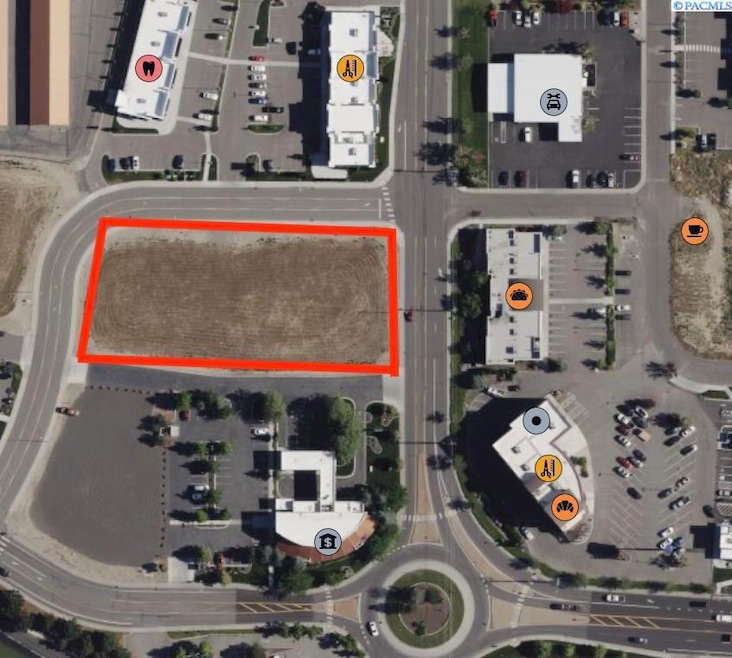
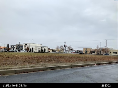
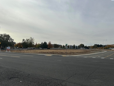
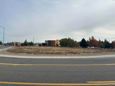
MLS# 279653 Prime, fully developed and “shovel ready” Kennewick lot for sale within the growth development area of Southridge. Great location for medical, office, condos, retail and mixed use. Located on South Union and West 26th near Creekstone Drive and near Highway 395 and Trios Hospital. Lot is relatively flat requiring very little grading and no special soil engineering, as opposed to other available nearby lots. Lot is located on wide City maintained public streets with left turn lanes allowing for multiple ingress/egress access. Wide exterior sidewalks are paved along with all utilities, and irrigation water. Deep gravity flow sewer lines exist for basements and underground parking. City allows for up to 60’ high signage for high visibility. Preliminary Title Report is available with Kemal Suljic at Cascade Title. Please contact LA for more information.
Property Details
Property Type
- Land
Est. Annual Taxes
- $4,027
Lot Details
- 1.43 Acre Lot
- Irrigation
- Zoning described as COMMCL GENERAL
Additional Features
- Property Views
Map
Home Values in the Area
Average Home Value in this Area
Tax History
| Year | Tax Paid | Tax Assessment Tax Assessment Total Assessment is a certain percentage of the fair market value that is determined by local assessors to be the total taxable value of land and additions on the property. | Land | Improvement |
|---|---|---|---|---|
| 2024 | $4,027 | $588,160 | $588,160 | -- |
| 2023 | $4,027 | $509,080 | $509,080 | $0 |
| 2022 | $3,983 | $411,190 | $411,190 | $0 |
| 2021 | $4,108 | $411,190 | $411,190 | $0 |
| 2020 | $4,298 | $411,190 | $411,190 | $0 |
| 2019 | $4,201 | $411,190 | $411,190 | $0 |
| 2018 | $5,135 | $411,190 | $411,190 | $0 |
| 2017 | $4,747 | $411,190 | $411,190 | $0 |
| 2016 | $5,202 | $411,190 | $411,190 | $0 |
| 2015 | $4,709 | $411,190 | $411,190 | $0 |
| 2014 | -- | $367,130 | $367,130 | $0 |
| 2013 | -- | $367,130 | $367,130 | $0 |
Property History
| Date | Event | Price | List to Sale | Price per Sq Ft |
|---|---|---|---|---|
| 10/10/2025 10/10/25 | For Sale | $879,000 | 0.0% | -- |
| 10/01/2025 10/01/25 | Off Market | $879,000 | -- | -- |
| 09/23/2025 09/23/25 | For Sale | $879,000 | 0.0% | -- |
| 09/01/2025 09/01/25 | Off Market | $879,000 | -- | -- |
| 08/07/2025 08/07/25 | For Sale | $879,000 | 0.0% | -- |
| 08/01/2025 08/01/25 | Off Market | $879,000 | -- | -- |
| 07/02/2025 07/02/25 | For Sale | $879,000 | 0.0% | -- |
| 07/01/2025 07/01/25 | Off Market | $879,000 | -- | -- |
| 06/27/2025 06/27/25 | Price Changed | $879,000 | -2.2% | -- |
| 06/02/2025 06/02/25 | For Sale | $899,000 | 0.0% | -- |
| 06/01/2025 06/01/25 | Off Market | $899,000 | -- | -- |
| 04/14/2025 04/14/25 | For Sale | $899,000 | 0.0% | -- |
| 04/14/2025 04/14/25 | Off Market | $899,000 | -- | -- |
| 10/16/2024 10/16/24 | For Sale | $899,000 | -- | -- |
Purchase History
| Date | Type | Sale Price | Title Company |
|---|---|---|---|
| Quit Claim Deed | -- | Benton Franklin Title Co | |
| Interfamily Deed Transfer | -- | Benton Franklin Title Co |
Mortgage History
| Date | Status | Loan Amount | Loan Type |
|---|---|---|---|
| Previous Owner | $175,000 | Seller Take Back |
Source: Pacific Regional MLS
MLS Number: 279653
APN: 109894012836006
Disclaimer: Certain information contained herein is derived from information provided by parties other than Homes.com. All information provided is deemed reliable, but is not guaranteed to be accurate and should be independently verified.
![]() IDX information is provided exclusively for personal, non-commercial use, and may not be used for any purpose other than to identify prospective properties consumers may be interested in purchasing.
IDX information is provided exclusively for personal, non-commercial use, and may not be used for any purpose other than to identify prospective properties consumers may be interested in purchasing.
Information is deemed reliable but not guaranteed.
- 2606 S Williams Place
- 4175 W 24th Ave
- 2451 S Arthur Ct
- 4311 W 22nd Ave
- 2401 S Arthur Ct
- 2017 S Sheppard Place
- 4915 W 24th Ave
- 6613 W 27th Ave
- 6629 W 27th Ave
- 6637 W 27th Ave
- 6669 W 27th Ave
- 6645 W 27th Ave
- 6685 W 27th Ave
- 6621 W 27th Ave
- 6653 W 27th Ave Unit Lot26
- 6677 W 27th Ave
- 2017 S Tweedt St
- 4713 W 20th Ave
- 2015 S Sheppard St
- Lot 18, Phase 8 W 21st Ave Unit Lot18
- 4112 W 24th Ave
- 3001 S Dawes St
- 5207 W Hildebrand Blvd
- 5501 W Hildebrand Blvd
- 3509 S Johnson St
- 5651 W 36th Place
- 589 S Quillan Place
- 7260 W 25th Ave
- 3030 W 4th Ave
- 30 N Sheppard Place
- 5225 W Clearwater Ave
- 3214 S Quincy Place
- 7175 W 35th Ave
- 318 N Arthur St
- 5100 W Clearwater Ave
- 7330 W 22nd Place
- 5809 W Clearwater Ave
- 445 N Volland St
- 526 N Grant St
- 4302 W Hood Ave
