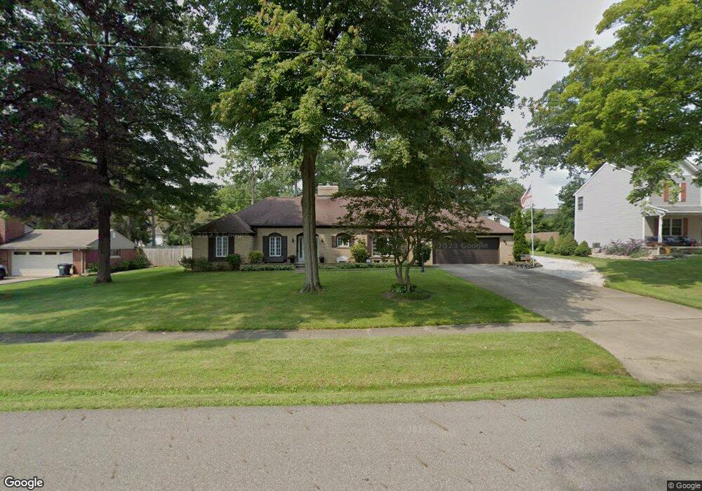
2605 Belleflower Dr Alliance, OH 44601
Estimated Value: $285,000 - $322,231
3
Beds
2
Baths
2,573
Sq Ft
$117/Sq Ft
Est. Value
About This Home
This home is located at 2605 Belleflower Dr, Alliance, OH 44601 and is currently estimated at $301,308, approximately $117 per square foot. 2605 Belleflower Dr is a home located in Stark County with nearby schools including Alliance Elementary School at Rockhill, Alliance Intermediate School at Northside, and Alliance Middle School.
Ownership History
Date
Name
Owned For
Owner Type
Purchase Details
Closed on
Oct 12, 2005
Sold by
Unizan Financial Services Group Na
Bought by
Messmore David A and Messmore Vickie
Current Estimated Value
Purchase Details
Closed on
May 28, 1992
Create a Home Valuation Report for This Property
The Home Valuation Report is an in-depth analysis detailing your home's value as well as a comparison with similar homes in the area
Home Values in the Area
Average Home Value in this Area
Purchase History
| Date | Buyer | Sale Price | Title Company |
|---|---|---|---|
| Messmore David A | $127,000 | Union Title Co | |
| -- | -- | -- |
Source: Public Records
Tax History Compared to Growth
Tax History
| Year | Tax Paid | Tax Assessment Tax Assessment Total Assessment is a certain percentage of the fair market value that is determined by local assessors to be the total taxable value of land and additions on the property. | Land | Improvement |
|---|---|---|---|---|
| 2025 | -- | $103,670 | $20,580 | $83,090 |
| 2024 | -- | $103,670 | $20,580 | $83,090 |
| 2023 | $2,690 | $76,030 | $16,000 | $60,030 |
| 2022 | $2,725 | $76,030 | $16,000 | $60,030 |
| 2021 | $2,727 | $76,030 | $16,000 | $60,030 |
| 2020 | $2,390 | $63,810 | $13,930 | $49,880 |
| 2019 | $2,356 | $63,810 | $13,930 | $49,880 |
| 2018 | $2,367 | $63,810 | $13,930 | $49,880 |
| 2017 | $2,260 | $60,450 | $12,880 | $47,570 |
| 2016 | $1,933 | $52,580 | $15,120 | $37,460 |
| 2015 | $1,950 | $52,580 | $15,120 | $37,460 |
| 2014 | $1,836 | $48,030 | $13,830 | $34,200 |
| 2013 | $916 | $48,030 | $13,830 | $34,200 |
Source: Public Records
Map
Nearby Homes
- 2705 Shunk Ave
- 2839 S Rockhill Ave
- 549 Linwood Dr
- 3101 Ridgehill Ave
- 1059 Oakwood Dr
- 2372 S Union Ave
- 2405 Cherry Ave
- 236 E Milton St
- 884 W College Rd
- 2460 S Arch Ave
- 2112 Blenheim Ave
- 2195 Blenheim Ave
- 1515 S Rockhill Ave
- 2408 S Linden Ave
- 277 W Carol St
- 2220 Western Ave
- 317 E State St
- 112 E College St
- 1325 W Beech St
- 555 E Milton St
- 2551 Belleflower Dr
- 2616 Ridgewood Ave
- 2606 Ridgewood Ave
- 2630 Ridgewood Ave
- 2552 Ridgewood Ave
- 2614 Belleflower Dr
- 2640 Ridgewood Ave
- 2550 Belleflower Dr
- 2655 Belleflower Dr
- 2542 Ridgewood Ave
- 2541 Belleflower Dr
- 2630 Belleflower Dr
- 2708 Ridgewood Ave
- 2530 Ridgewood Ave
- 2654 Belleflower Dr
- 2727 Belleflower Dr
- 2718 Ridgewood Ave
- 2501 Belleflower Dr
- 2611 Ridgewood Ave
- 2629 Ridgewood Ave