Estimated payment $3,065/month
Highlights
- Horses Allowed On Property
- 37.64 Acre Lot
- Main Floor Primary Bedroom
- View of Trees or Woods
- Near a National Forest
- High Ceiling
About This Home
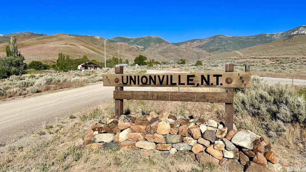
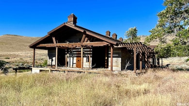
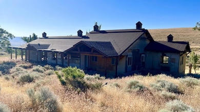
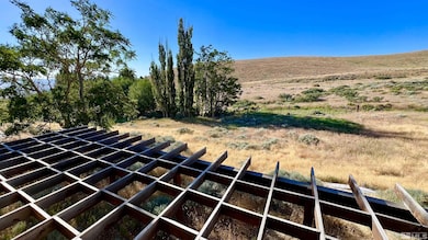
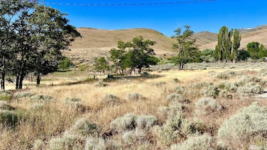
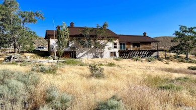
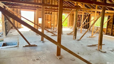
Unionville Creek runs through it! Unionville road splits this beautiful 37.64 acre property with the creek running along the south boundary. The original home was built in 1910, expanded and modernized in 1967, gutted in the 2010's and continues to be a work in progress. Large decks have been started to take advantage of the amazing creek, mountain, and Buena Vista Valley views. Property includes a large pond with pier, gorgeous trees along the creek, open grassy areas, areas for gardens,, and fruit trees. Surface water rights off Unionville Creek provides the ability to have a stocked pond and a resource for irrigating the property. New well was drilled in 2013. Electrical service available on both sides of the road. Plenty of space for outbuildings, garages, barns, etc. Schedule your showing today!
Home Details
Home Type
- Single Family
Est. Annual Taxes
- $350
Year Built
- Built in 1910
Lot Details
- 37.64 Acre Lot
- Creek or Stream
- Partially Fenced Property
- Open Lot
- Property is zoned AMR
Property Views
- Woods
- Mountain
- Desert
- Meadow
Home Design
- Slab Foundation
- Shingle Roof
- Composition Roof
- Stick Built Home
Interior Spaces
- 3,589 Sq Ft Home
- 2-Story Property
- High Ceiling
- Open Floorplan
- No Floor Coverings
- No Kitchen Appliances
- Unfinished Basement
Bedrooms and Bathrooms
- 4 Bedrooms
- Primary Bedroom on Main
- 2 Full Bathrooms
Schools
- Lovelock Elementary School
- Pershing Middle School
- Pershing High School
Utilities
- Heating System Uses Propane
- Propane
- Water Rights
- Private Water Source
- Well
- No Water Heater
- Septic Tank
Additional Features
- Property is near a creek
- Horses Allowed On Property
Listing and Financial Details
- Assessor Parcel Number 012-030-10
Community Details
Overview
- No Home Owners Association
- Unionville Cdp Community
- Near a National Forest
Amenities
- No Laundry Facilities
Map
Home Values in the Area
Average Home Value in this Area
Tax History
| Year | Tax Paid | Tax Assessment Tax Assessment Total Assessment is a certain percentage of the fair market value that is determined by local assessors to be the total taxable value of land and additions on the property. | Land | Improvement |
|---|---|---|---|---|
| 2025 | $379 | $12,491 | $4,282 | $8,209 |
| 2024 | $379 | $12,341 | $4,282 | $8,059 |
| 2023 | $379 | $11,703 | $4,282 | $7,421 |
| 2022 | $445 | $10,479 | $4,282 | $6,197 |
| 2021 | $1,075 | $31,944 | $6,955 | $24,989 |
| 2020 | $1,052 | $30,111 | $5,350 | $24,761 |
| 2019 | $1,018 | $29,006 | $5,350 | $23,656 |
| 2018 | $986 | $27,956 | $5,350 | $22,606 |
| 2017 | $972 | $27,511 | $5,350 | $22,161 |
| 2016 | $1,381 | $40,911 | $5,350 | $35,561 |
| 2015 | $1,382 | $41,090 | $5,350 | $35,740 |
| 2014 | $1,382 | $41,270 | $5,350 | $35,920 |
Property History
| Date | Event | Price | List to Sale | Price per Sq Ft |
|---|---|---|---|---|
| 06/13/2024 06/13/24 | For Sale | $575,000 | -- | $160 / Sq Ft |
Purchase History
| Date | Type | Sale Price | Title Company |
|---|---|---|---|
| Grant Deed | -- | -- |
Source: Northern Nevada Regional MLS
MLS Number: 240007369
APN: 012-030-10
Disclaimer: Certain information contained herein is derived from information provided by parties other than Homes.com. All information provided is deemed reliable, but is not guaranteed to be accurate and should be independently verified.
![]() IDX information is provided exclusively for personal, non-commercial use, and may not be used for any purpose other than to identify prospective properties consumers may be interested in purchasing. Information is deemed reliable but not guaranteed. The content relating to real estate for sale on this web site comes in part from the Broker Reciprocity/ IDX program of the Northern Nevada Regional Multiple Listing Service°. Real estate listings held by brokerage firms other than Ten-X are marked with the Broker Reciprocity logo and detailed information about those listings includes the name of the listing brokerage. Any use of the content other than by a search performed by a consumer looking to purchase or rent real estate is prohibited. © 2025 Northern Nevada Regional Multiple Listing Service® MLS. All rights reserved.
IDX information is provided exclusively for personal, non-commercial use, and may not be used for any purpose other than to identify prospective properties consumers may be interested in purchasing. Information is deemed reliable but not guaranteed. The content relating to real estate for sale on this web site comes in part from the Broker Reciprocity/ IDX program of the Northern Nevada Regional Multiple Listing Service°. Real estate listings held by brokerage firms other than Ten-X are marked with the Broker Reciprocity logo and detailed information about those listings includes the name of the listing brokerage. Any use of the content other than by a search performed by a consumer looking to purchase or rent real estate is prohibited. © 2025 Northern Nevada Regional Multiple Listing Service® MLS. All rights reserved.
- 0 Coyote Canyon Rd Unit 250058510
- 1600 Kyle Hot Springs Rd
- 25200 Ramsey Rd Unit 37
- 25355 Buffalo Canyon Rd
- 25055 Ramsey Rd Unit 31
- 12455 Beaumont Trail
- 11315 Beaumont Trail
- 10980 Beaumont Trail
- 11155 Beaumont Trail
- 12240 Pershing Trail
- 11230 Winter River Dr
- 11180 Winter River Dr
- 11305 Beaumont Trail
- 12710 Carson Dr
- 12735 Carson Dr Unit 95
- 12275 Churchill Trail
- 22020 Atlantis Ct
- 12860 Reno Dr
- 22025 Fall River Dr
- 12750 Ruby Lake Trail
