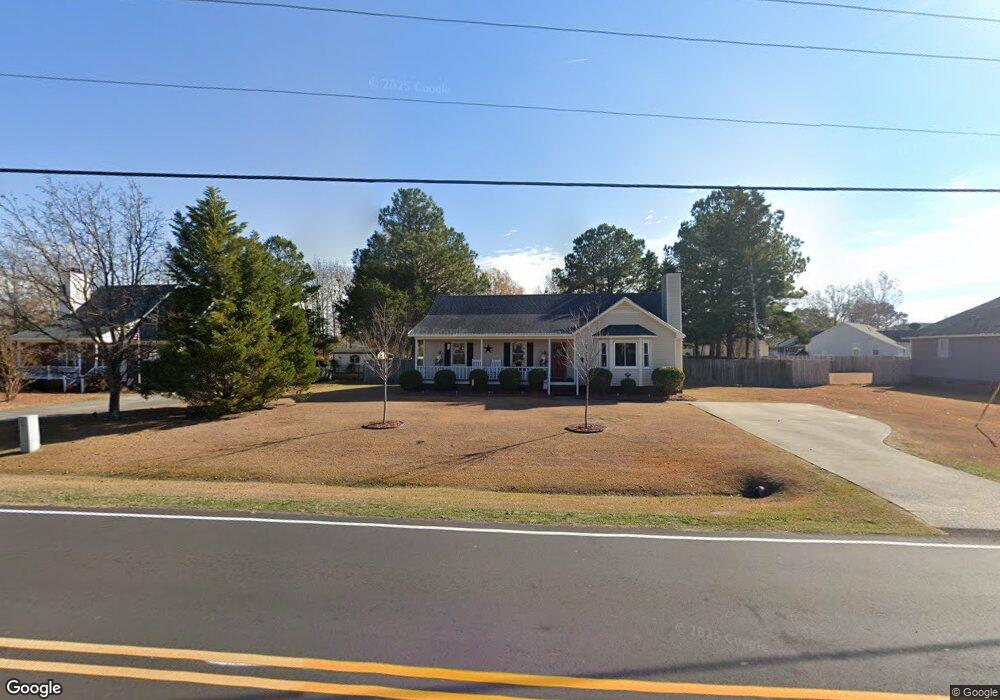
2607 Thomas Langston Rd Winterville, NC 28590
Estimated Value: $211,000 - $256,000
3
Beds
2
Baths
1,316
Sq Ft
$175/Sq Ft
Est. Value
About This Home
This home is located at 2607 Thomas Langston Rd, Winterville, NC 28590 and is currently estimated at $229,840, approximately $174 per square foot. 2607 Thomas Langston Rd is a home located in Pitt County with nearby schools including Creekside Elementary School, A.G. Cox Middle School, and South Central High School.
Ownership History
Date
Name
Owned For
Owner Type
Purchase Details
Closed on
Sep 30, 2005
Sold by
Grant David B and Williford Voctoria Brooke
Bought by
Martin Mark P
Current Estimated Value
Home Financials for this Owner
Home Financials are based on the most recent Mortgage that was taken out on this home.
Original Mortgage
$123,601
Outstanding Balance
$66,199
Interest Rate
5.77%
Mortgage Type
New Conventional
Estimated Equity
$163,641
Create a Home Valuation Report for This Property
The Home Valuation Report is an in-depth analysis detailing your home's value as well as a comparison with similar homes in the area
Home Values in the Area
Average Home Value in this Area
Purchase History
| Date | Buyer | Sale Price | Title Company |
|---|---|---|---|
| Martin Mark P | $121,000 | None Available |
Source: Public Records
Mortgage History
| Date | Status | Borrower | Loan Amount |
|---|---|---|---|
| Open | Martin Mark P | $123,601 |
Source: Public Records
Tax History Compared to Growth
Tax History
| Year | Tax Paid | Tax Assessment Tax Assessment Total Assessment is a certain percentage of the fair market value that is determined by local assessors to be the total taxable value of land and additions on the property. | Land | Improvement |
|---|---|---|---|---|
| 2025 | $1,684 | $211,880 | $30,000 | $181,880 |
| 2024 | $1,672 | $211,880 | $30,000 | $181,880 |
| 2023 | $1,299 | $139,047 | $30,000 | $109,047 |
| 2022 | $1,305 | $139,047 | $30,000 | $109,047 |
| 2021 | $1,265 | $139,047 | $30,000 | $109,047 |
| 2020 | $1,253 | $139,047 | $30,000 | $109,047 |
| 2019 | $1,111 | $122,202 | $28,000 | $94,202 |
| 2018 | $1,042 | $122,202 | $28,000 | $94,202 |
| 2017 | $1,042 | $122,202 | $28,000 | $94,202 |
| 2016 | $1,029 | $122,202 | $28,000 | $94,202 |
| 2015 | $1,032 | $124,195 | $28,000 | $96,195 |
| 2014 | $1,032 | $124,195 | $28,000 | $96,195 |
Source: Public Records
Map
Nearby Homes
- 828 Emerald Park Dr
- 518 Shadow Ridge Dr
- 2104 Rhinestone Dr
- 2201 Rhinestone Dr
- 605 Huff Dr
- Sumner Plan at Davenport Farms
- Dunley Plan at Davenport Farms
- Jordan Plan at Davenport Farms
- Dakota Plan at Davenport Farms
- Ryder Plan at Davenport Farms
- Bradley Plan at Davenport Farms
- Wyatt Plan at Davenport Farms
- Ivy Plan at Davenport Farms
- Emily Plan at Davenport Farms
- Turner Plan at Davenport Farms
- Westbrook Plan at Davenport Farms
- Rockbridge Plan at Davenport Farms
- 2105 Rhinestone Dr
- 2109 Rhinestone Dr
- 512 Huff Dr
- 2615 Thomas Langston Rd
- 2597 Thomas Langston Rd
- 609 Cliff Ct
- 604 Cliff Ct
- 2623 Thomas Langston Rd
- 2537 Rhinestone Dr
- 605 Cliff Ct
- 2533 Rhinestone Dr
- 2541 Rhinestone Dr
- 2118 Scotsdale Ct
- 2545 Rhinestone Dr
- 2529 Rhinestone Dr
- 2631 Thomas Langston Rd
- 600 Cliff Ct
- 2121 Scotsdale Ct
- 603 Cliff Ct
- 2581 Thomas Langston Rd
- 2561 Rhinestone Dr
- 2116 Scotsdale Ct
- 2586 Thomas Langston Rd