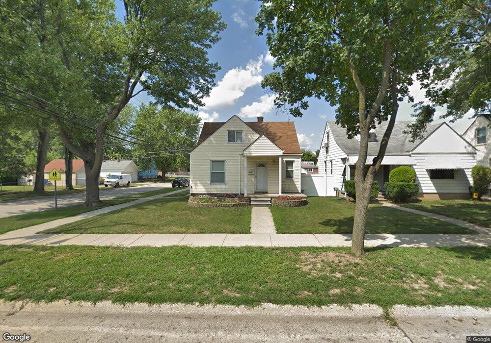
26072 Pennie St Dearborn Heights, MI 48125
Estimated Value: $140,000 - $172,114
--
Bed
1
Bath
1,141
Sq Ft
$140/Sq Ft
Est. Value
About This Home
This home is located at 26072 Pennie St, Dearborn Heights, MI 48125 and is currently estimated at $159,779, approximately $140 per square foot. 26072 Pennie St is a home located in Wayne County with nearby schools including Quest Charter Academy, West Village Academy, and Peterson-Warren Academy.
Ownership History
Date
Name
Owned For
Owner Type
Purchase Details
Closed on
Mar 28, 2003
Sold by
Wilder Peter J and Wilder Gerald W
Bought by
Wilder Peter J
Current Estimated Value
Purchase Details
Closed on
Sep 14, 2001
Sold by
Geoform Inc
Bought by
Wilder Gerald W
Purchase Details
Closed on
Apr 12, 2000
Sold by
Contimortgage Corp
Bought by
Wilder Gerald W
Purchase Details
Closed on
Mar 10, 1999
Sold by
Jefferson Latawnya S
Bought by
Principal Wholesale Mtg
Purchase Details
Closed on
Nov 22, 1996
Sold by
Leonard Bale E and Leonard Carol E
Bought by
Alley James W
Create a Home Valuation Report for This Property
The Home Valuation Report is an in-depth analysis detailing your home's value as well as a comparison with similar homes in the area
Home Values in the Area
Average Home Value in this Area
Purchase History
| Date | Buyer | Sale Price | Title Company |
|---|---|---|---|
| Wilder Peter J | -- | -- | |
| Wilder Gerald W | -- | -- | |
| Wilder Gerald W | $61,500 | -- | |
| Principal Wholesale Mtg | $51,808 | -- | |
| Alley James W | $62,000 | -- |
Source: Public Records
Tax History Compared to Growth
Tax History
| Year | Tax Paid | Tax Assessment Tax Assessment Total Assessment is a certain percentage of the fair market value that is determined by local assessors to be the total taxable value of land and additions on the property. | Land | Improvement |
|---|---|---|---|---|
| 2025 | $1,448 | $87,500 | $0 | $0 |
| 2024 | $1,448 | $73,900 | $0 | $0 |
| 2023 | $1,301 | $63,700 | $0 | $0 |
| 2022 | $1,763 | $53,300 | $0 | $0 |
| 2021 | $1,766 | $46,700 | $0 | $0 |
| 2019 | $1,610 | $36,400 | $0 | $0 |
| 2018 | $1,127 | $34,200 | $0 | $0 |
| 2017 | $883 | $33,300 | $0 | $0 |
| 2016 | $1,530 | $33,800 | $0 | $0 |
| 2015 | $3,160 | $31,600 | $0 | $0 |
| 2013 | $3,440 | $36,000 | $0 | $0 |
| 2010 | -- | $41,400 | $0 | $0 |
Source: Public Records
Map
Nearby Homes
- 26106 Powers Ave
- 25926 Powers Ave
- 26225 McDonald St
- 25965 Currier St
- 25895 Annapolis St
- 25628 Powers Ave
- 26532 Powers Ave
- 26439 Hopkins St
- 26159 Stanford St
- 4863 Glenis St
- 26458 Hopkins St
- 25474 McDonald St
- 5845 Beech Daly Rd
- 26202 Colgate St
- 5118 Michael St
- 5842 Janet St
- 5961 Marvin St
- 26231 Andover St
- 5961 Beech Daly Rd
- 25866 Andover St
- 26062 Pennie St
- 26054 Pennie St Unit Bldg-Unit
- 26054 Pennie St
- 26054 Pennie
- 26104 Pennie St
- 26069 Eton Ave
- 26046 Pennie St
- 26057 Eton Ave
- 26114 Pennie St
- 26045 Eton Ave
- 26105 Eton Ave
- 26038 Pennie St
- 26033 Eton Ave
- 26063 Pennie St
- 26124 Pennie St Unit Bldg-Unit
- 26124 Pennie St
- 26073 Pennie St
- 26016 Pennie St
- 26021 Eton Ave Unit Bldg-Unit
- 26021 Eton Ave