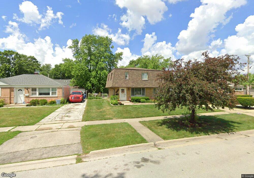
2610 Eisenhower Dr Des Plaines, IL 60018
Estimated Value: $410,000 - $460,000
4
Beds
2
Baths
1,768
Sq Ft
$245/Sq Ft
Est. Value
About This Home
This home is located at 2610 Eisenhower Dr, Des Plaines, IL 60018 and is currently estimated at $433,660, approximately $245 per square foot. 2610 Eisenhower Dr is a home located in Cook County with nearby schools including Orchard Place Elementary School, Algonquin Middle School, and Maine West High School.
Ownership History
Date
Name
Owned For
Owner Type
Purchase Details
Closed on
Jan 15, 2002
Sold by
Kaminski Andrzej
Bought by
Garcia Jose A and Garcia Lisa M
Current Estimated Value
Home Financials for this Owner
Home Financials are based on the most recent Mortgage that was taken out on this home.
Original Mortgage
$227,050
Interest Rate
7.11%
Purchase Details
Closed on
Aug 30, 2001
Sold by
Chien Roger K and Chien Lilian L
Bought by
Kaminski Andrzej
Home Financials for this Owner
Home Financials are based on the most recent Mortgage that was taken out on this home.
Original Mortgage
$166,500
Interest Rate
6.97%
Create a Home Valuation Report for This Property
The Home Valuation Report is an in-depth analysis detailing your home's value as well as a comparison with similar homes in the area
Home Values in the Area
Average Home Value in this Area
Purchase History
| Date | Buyer | Sale Price | Title Company |
|---|---|---|---|
| Garcia Jose A | $239,000 | Stewart Title | |
| Kaminski Andrzej | $185,000 | -- |
Source: Public Records
Mortgage History
| Date | Status | Borrower | Loan Amount |
|---|---|---|---|
| Previous Owner | Garcia Jose A | $227,050 | |
| Previous Owner | Kaminski Andrzej | $166,500 |
Source: Public Records
Tax History
| Year | Tax Paid | Tax Assessment Tax Assessment Total Assessment is a certain percentage of the fair market value that is determined by local assessors to be the total taxable value of land and additions on the property. | Land | Improvement |
|---|---|---|---|---|
| 2025 | $7,563 | $39,000 | $9,018 | $29,982 |
| 2024 | $7,563 | $32,000 | $7,515 | $24,485 |
| 2023 | $7,354 | $32,000 | $7,515 | $24,485 |
| 2022 | $7,354 | $32,000 | $7,515 | $24,485 |
| 2021 | $6,193 | $23,479 | $6,262 | $17,217 |
| 2020 | $6,158 | $23,479 | $6,262 | $17,217 |
| 2019 | $6,177 | $26,381 | $6,262 | $20,119 |
| 2018 | $6,355 | $24,684 | $5,511 | $19,173 |
| 2017 | $6,260 | $24,684 | $5,511 | $19,173 |
| 2016 | $6,165 | $24,684 | $5,511 | $19,173 |
| 2015 | $6,854 | $25,296 | $4,759 | $20,537 |
| 2014 | $6,726 | $25,296 | $4,759 | $20,537 |
| 2013 | $6,541 | $25,296 | $4,759 | $20,537 |
Source: Public Records
Map
Nearby Homes
- 2609 Eisenhower Dr
- 2646 Maple St
- 2600 S Scott St
- 1757 Farwell Ave
- 2993 Curtis St Unit 13
- 1641 E Touhy Ave
- 1629 E Touhy Ave
- 2945 S Scott St
- 2469 Parkwood Ln
- 1738 Lunt Ave
- 38 E Touhy Ave
- 2035 Fargo Ave
- 1922 Fargo Ave
- 2054 Birch St
- 1370 Fargo Ave Unit E
- 10016 Estelle Dr
- 300 Thames Pkwy Unit 3D
- 1881 Orchard St
- 500 Thames Pkwy Unit 3G
- 500 Thames Pkwy Unit 1F
- 2616 Eisenhower Dr
- 2604 Eisenhower Dr
- 2626 Eisenhower Dr
- 1886 Paula Ln
- 1941 Laura Ln
- 1885 Paula Ln
- 1945 Laura Ln
- 2636 Eisenhower Dr
- 1931 Laura Ln
- 1935 Laura Ln
- 1925 Laura Ln
- 2609 Eisenhower Dr
- 2615 Eisenhower Dr
- 2601 Eisenhower Dr
- 2650 Eisenhower Dr
- 1951 Laura Ln
- 2623 Eisenhower Dr
- 1876 Paula Ln
- 1917 Laura Ln
- 1881 Paula Ln
Your Personal Tour Guide
Ask me questions while you tour the home.