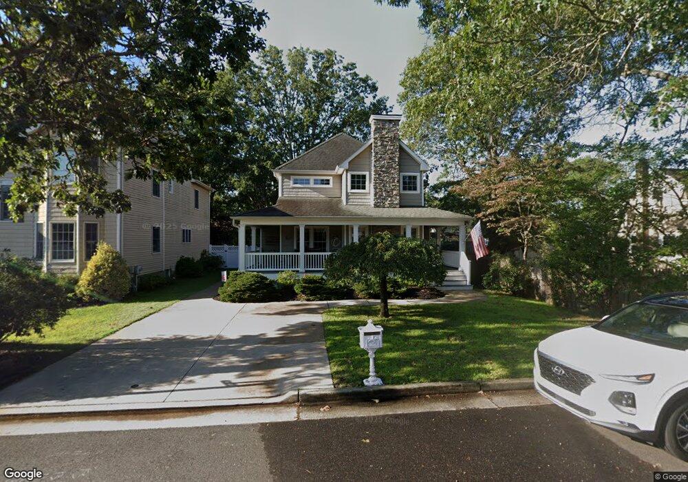
2610 Maple St Point Pleasant Boro, NJ 08742
Estimated Value: $697,825 - $913,000
3
Beds
3
Baths
2,526
Sq Ft
$321/Sq Ft
Est. Value
About This Home
This home is located at 2610 Maple St, Point Pleasant Boro, NJ 08742 and is currently estimated at $811,206, approximately $321 per square foot. 2610 Maple St is a home located in Ocean County with nearby schools including Point Pleasant High School and St Dominic School.
Ownership History
Date
Name
Owned For
Owner Type
Purchase Details
Closed on
Oct 30, 2017
Sold by
Baumeister David H and Baumeister Janet
Bought by
Cranston Sean and Cranston Julie
Current Estimated Value
Home Financials for this Owner
Home Financials are based on the most recent Mortgage that was taken out on this home.
Original Mortgage
$230,000
Outstanding Balance
$192,627
Interest Rate
3.83%
Mortgage Type
New Conventional
Estimated Equity
$618,579
Purchase Details
Closed on
Apr 24, 2003
Create a Home Valuation Report for This Property
The Home Valuation Report is an in-depth analysis detailing your home's value as well as a comparison with similar homes in the area
Home Values in the Area
Average Home Value in this Area
Purchase History
| Date | Buyer | Sale Price | Title Company |
|---|---|---|---|
| Cranston Sean | $450,000 | Westcor Land Title | |
| -- | $100 | -- |
Source: Public Records
Mortgage History
| Date | Status | Borrower | Loan Amount |
|---|---|---|---|
| Open | Cranston Sean | $230,000 |
Source: Public Records
Tax History Compared to Growth
Tax History
| Year | Tax Paid | Tax Assessment Tax Assessment Total Assessment is a certain percentage of the fair market value that is determined by local assessors to be the total taxable value of land and additions on the property. | Land | Improvement |
|---|---|---|---|---|
| 2025 | $8,787 | $384,200 | $160,000 | $224,200 |
| 2024 | $8,399 | $384,200 | $160,000 | $224,200 |
| 2023 | $8,226 | $384,200 | $160,000 | $224,200 |
| 2022 | $8,226 | $384,200 | $160,000 | $224,200 |
| 2021 | $6,150 | $384,200 | $160,000 | $224,200 |
| 2020 | $7,795 | $373,700 | $160,000 | $213,700 |
| 2019 | $7,691 | $373,700 | $160,000 | $213,700 |
| 2018 | $7,463 | $373,700 | $160,000 | $213,700 |
| 2017 | $7,298 | $373,700 | $160,000 | $213,700 |
| 2016 | $7,242 | $373,700 | $160,000 | $213,700 |
| 2015 | $7,156 | $373,700 | $160,000 | $213,700 |
| 2014 | $6,992 | $373,700 | $160,000 | $213,700 |
Source: Public Records
Map
Nearby Homes
- 2607 Spruce St
- 1111 River Ave
- 2406 Chestnut St
- 2704 Route 88
- 2504 Oak St
- 2400 Beech St
- 3105 Pocahontas Ave
- 519 Curtis Ave
- 602 Boulton Ave
- 1119 Northstream Pkwy
- 3118 Pocahontas Ave
- 505 Curtis Ave
- 1315 Sunset Ave
- 837 Beaver Dam Rd
- 1115 Beaver Dam Rd
- 1404-1406 Treeneedle Rd
- 530 Riverwood Ave
- 1027 Ocean Rd
- 1328 Sleepy Hollow Rd
- 709 Albert E Clifton Ave
- 2608 Maple St
- 1010 Curtis Ave
- 2612 Maple St
- 2605 Willow St
- 2606 Maple St
- 1012 Curtis Ave
- 2609 Maple St
- 2611 Maple St
- 2603 Willow St
- 1014 Curtis Ave
- 2613 Maple St
- 2605 Maple St
- 1009 Barton Ave
- 1011 Barton Ave
- 1004 Curtis Ave
- 1015 Barton Ave
- 2608 Willow St
- 2610 Chestnut St
- 2606 Chestnut St Unit 2608
- 2606 Willow St